EPW028556 ENGLAND (1929) [Unlocated]. UNLOCATED
    © Hawlfraint cyfranwyr OpenStreetMap a thrwyddedwyd gan yr OpenStreetMap Foundation. 2025. Trwyddedir y gartograffeg fel CC BY-SA.
  
Delweddau cyfagos (48)
Manylion
| Pennawd | [EPW028556] UNLOCATED | 
| Cyfeirnod | EPW028556 | 
| Dyddiad | August-1929 | 
| Dolen | |
| Enw lle | |
| Plwyf | |
| Ardal | |
| Gwlad | ENGLAND | 
| Dwyreiniad / Gogleddiad | 0, 0 | 
| Hydred / Lledred | -7.556448482059, 49.766185796754 | 
| Cyfeirnod Grid Cenedlaethol | SV000000 | 
Pinnau
|  Lambeg Bleaching Co, Lambeg, Lisburn, Northern Ireland |   Graeme | Saturday 9th of May 2015 06:47:45 AM | 
| I'm not convinced. While I can see where you are coming from with the river and the general shape of the site, take a look at XAW009566. Its 20 years later, but the surroundings are vastly different, many trees have disappeared and quite a few more have appeared. Also the buildings are quite different. Compare with the other shots around XAW009566. |   Wolfie | Saturday 11th of December 2021 08:38:30 PM | 
|  Canal or river, possibly for use by factory, hence bridge as well. But I can't see a towpath, so maybe a river. |   Mozzy | Monday 29th of December 2014 06:35:23 PM | 
|  Seems like an original house and cottages, that has been developed as a business became successful. Possibly a mill of some sort. It does seem quite rural. |   Mozzy | Monday 29th of December 2014 06:34:28 PM | 
|  what are the white spots in this field and the field towards the back of the photo? Are they circles of dead grass where bell tents have been pitched? |   Will Wallace | Saturday 24th of May 2014 09:16:58 PM | 
|  Is this a row of fuel pumps? |   Great North Road | Friday 21st of February 2014 10:12:04 AM | 
|  Horse pulling a a man on a thresher or some other haymaking machinery? |   Scapa | Friday 28th of December 2012 02:42:30 AM | 
|  Suspension bridge |   TomRobin | Sunday 21st of October 2012 07:02:49 PM | 
|  Railway embankment |   TomRobin | Sunday 21st of October 2012 07:02:18 PM | 
Cyfraniadau Grŵp
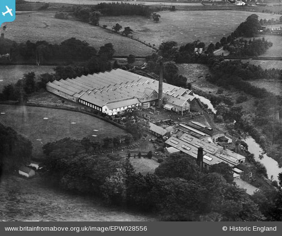
| This is the Lambeg Bleaching Co, Lambeg, Lisburn, Northern Ireland, 1929. It is the same factory shown on the following photos, XPW028651 & XPW028652, so probably a numbering error in the image reference. |   Graeme | Sunday 7th of June 2015 10:42:58 AM | 
| Well Spotted Graeme, great to have another of the long term unlocated identified |   Dave Brunt | Wednesday 20th of May 2015 12:30:54 AM | 
| Well done Graeme for finding another of the more tricky ones which are left! | Class31 | Sunday 7th of June 2015 10:42:58 AM | 
| EPW028557 is taken in August 1929 and shows East Grinstead, West Sussex | Class31 | Sunday 5th of January 2014 11:49:12 PM | 
| I think you mean EPW028558. |   Tony D | Sunday 5th of January 2014 11:41:40 PM | 
| Sorry for my error. EPW028558 is of course of East Grinstead. Thanks Tony D | Class31 | Sunday 5th of January 2014 11:49:12 PM | 
| EPW028557 is unlocated and was taken in August 1929. EPW028557 shows a view which in my opinion looks likely to be in Kent or Sussex. | Class31 | Friday 3rd of January 2014 09:35:44 PM | 
| EPW028554 is taken in August 1929 of St. Alban's Church, Frant | Class31 | Friday 3rd of January 2014 09:32:31 PM | 
 
             
  ![[EPW000143] UNLOCATED](http://britainfromabove.org.uk/sites/all/libraries/aerofilms-images/public/100x100/EPW/000/EPW000143.jpg) 
  
                                          ![[EPW000667] Vessel at Sea](http://britainfromabove.org.uk/sites/all/libraries/aerofilms-images/public/100x100/EPW/000/EPW000667.jpg) 
 ![[EPW005260] UNLOCATED](http://britainfromabove.org.uk/sites/all/libraries/aerofilms-images/public/100x100/EPW/005/EPW005260.jpg) 
 ![[EPW006389] The R33 airship in flight over the Epsom Downs (unlocated), 1921](http://britainfromabove.org.uk/sites/all/libraries/aerofilms-images/public/100x100/EPW/006/EPW006389.jpg) 
 ![[EPW007181] UNLOCATED](http://britainfromabove.org.uk/sites/all/libraries/aerofilms-images/public/100x100/EPW/007/EPW007181.jpg) 
 ![[EPW015853] Cloudscape, 1926](http://britainfromabove.org.uk/sites/all/libraries/aerofilms-images/public/100x100/EPW/015/EPW015853.jpg) 
 ![[EPW015854] Cloudscape, 1926](http://britainfromabove.org.uk/sites/all/libraries/aerofilms-images/public/100x100/EPW/015/EPW015854.jpg) 
 ![[EPW015855] Cloudscape, 1926](http://britainfromabove.org.uk/sites/all/libraries/aerofilms-images/public/100x100/EPW/015/EPW015855.jpg) 
 ![[EPW016012] UNLOCATED](http://britainfromabove.org.uk/sites/all/libraries/aerofilms-images/public/100x100/EPW/016/EPW016012.jpg) 
 ![[EPW016510] Cloudscape, 1926](http://britainfromabove.org.uk/sites/all/libraries/aerofilms-images/public/100x100/EPW/016/EPW016510.jpg) 
 ![[EPW016641] EPW016641](http://britainfromabove.org.uk/sites/all/libraries/aerofilms-images/public/100x100/EPW/016/EPW016641.jpg) 
 ![[EPW017028] Cloudscape, 1926](http://britainfromabove.org.uk/sites/all/libraries/aerofilms-images/public/100x100/EPW/017/EPW017028.jpg) 
 ![[EPW017029] Cloudscape, 1926](http://britainfromabove.org.uk/sites/all/libraries/aerofilms-images/public/100x100/EPW/017/EPW017029.jpg) 
 ![[EPW017136] A vessel at sea off Beachy Head, from the east, 1926](http://britainfromabove.org.uk/sites/all/libraries/aerofilms-images/public/100x100/EPW/017/EPW017136.jpg) 
 ![[SAW003585] Skiddaw, Lake District.  Oblique aerial photograph.](http://britainfromabove.org.uk/sites/all/libraries/aerofilms-images/public/100x100/SAW/003/SAW003585.jpg) 
 ![[SAW003586] Unlocated mountains, possibly near Ben Nevis.  An oblique aerial photograph.](http://britainfromabove.org.uk/sites/all/libraries/aerofilms-images/public/100x100/SAW/003/SAW003586.jpg) 
 ![[SAW009337] Wigtown Bay, general view, showing Ringdoo Point.  An oblique aerial photograph taken facing west.](http://britainfromabove.org.uk/sites/all/libraries/aerofilms-images/public/100x100/SAW/009/SAW009337.jpg) 
 ![[SAW009800] Clouds.  An oblique aerial photograph.](http://britainfromabove.org.uk/sites/all/libraries/aerofilms-images/public/100x100/SAW/009/SAW009800.jpg) 
 ![[SAW009801] Clouds.  An oblique aerial photograph.](http://britainfromabove.org.uk/sites/all/libraries/aerofilms-images/public/100x100/SAW/009/SAW009801.jpg) 
 ![[SAW009802] Unlocated, Scotland, 1947. An oblique Aerial photograph.](http://britainfromabove.org.uk/sites/all/libraries/aerofilms-images/public/100x100/SAW/009/SAW009802.jpg) 
 ![[SAW010734] Clouds.  An oblique aerial photograph.](http://britainfromabove.org.uk/sites/all/libraries/aerofilms-images/public/100x100/SAW/010/SAW010734.jpg) 
 ![[SAW014737] Dalliefour Wood and River Dee, Balmoral Estate.  An oblique aerial photograph taken facing east.](http://britainfromabove.org.uk/sites/all/libraries/aerofilms-images/public/100x100/SAW/014/SAW014737.jpg) 
 ![[SAW017926] Unlocated image of haymaking, Dunbartonshire.  An oblique aerial photograph.](http://britainfromabove.org.uk/sites/all/libraries/aerofilms-images/public/100x100/SAW/017/SAW017926.jpg) 
 ![[SAW017927] Loch Ard  Forest, general view showing Beinn Bhreac, Loch Ard and Ben Venue. An oblique aerial photograph taken facing north-east. This image has been produced from a damaged negative.](http://britainfromabove.org.uk/sites/all/libraries/aerofilms-images/public/100x100/SAW/017/SAW017927.jpg) 
 ![[SAW032504] Unlocated country house, possibly near Ardanaiseig.  Oblique aerial photograph.  This image has been produced from a crop marked negative.](http://britainfromabove.org.uk/sites/all/libraries/aerofilms-images/public/100x100/SAW/032/SAW032504.jpg) 
 ![[SPW020275] Scottish Dyes Ltd. Works, Grangemouth.  An oblique aerial photograph taken facing north-west.](http://britainfromabove.org.uk/sites/all/libraries/aerofilms-images/public/100x100/SPW/020/SPW020275.jpg) 
 ![[SPW020280] Birds flying low between Grangemouth and Culross, Firth of Forth.  An oblique aerial photograph.](http://britainfromabove.org.uk/sites/all/libraries/aerofilms-images/public/100x100/SPW/020/SPW020280.jpg) 
 ![[SPW020281] Birds flying low between Grangemouth and Culross, Firth of Forth.  An oblique aerial photograph.](http://britainfromabove.org.uk/sites/all/libraries/aerofilms-images/public/100x100/SPW/020/SPW020281.jpg) 
 ![[SPW020284] Ochil Hills, general view, showing Carsebreck Loch and Lower and Upper Rhynd Reservoirs.  An oblique aerial photograph taken facing north-west.](http://britainfromabove.org.uk/sites/all/libraries/aerofilms-images/public/100x100/SPW/020/SPW020284.jpg) 
 ![[SPW020632] Unlocated moorland.  An oblique aerial photograph.](http://britainfromabove.org.uk/sites/all/libraries/aerofilms-images/public/100x100/SPW/020/SPW020632.jpg) 
 ![[SPW020633] Unlocated moorland.  An oblique aerial photograph.](http://britainfromabove.org.uk/sites/all/libraries/aerofilms-images/public/100x100/SPW/020/SPW020633.jpg) 
 ![[SPW027083] Unlocated hills in Peeblesshire.  An oblique aerial photograph.](http://britainfromabove.org.uk/sites/all/libraries/aerofilms-images/public/100x100/SPW/027/SPW027083.jpg) 
 ![[SPW049776] Queen Mary, Firth of Clyde.  An oblique aerial photograph.](http://britainfromabove.org.uk/sites/all/libraries/aerofilms-images/public/100x100/SPW/049/SPW049776.jpg) 
 ![[SPW049777] Queen Mary, Firth of Clyde.  An oblique aerial photograph.](http://britainfromabove.org.uk/sites/all/libraries/aerofilms-images/public/100x100/SPW/049/SPW049777.jpg) 
 ![[SPW049779] Queen Mary, Firth of Clyde.  An oblique aerial photograph.](http://britainfromabove.org.uk/sites/all/libraries/aerofilms-images/public/100x100/SPW/049/SPW049779.jpg) 
 ![[SPW049783] Queen Mary, Firth of Clyde.  An oblique aerial photograph.](http://britainfromabove.org.uk/sites/all/libraries/aerofilms-images/public/100x100/SPW/049/SPW049783.jpg) 
 ![[SPW049791] Queen Mary, River Clyde.  An oblique aerial photograph.](http://britainfromabove.org.uk/sites/all/libraries/aerofilms-images/public/100x100/SPW/049/SPW049791.jpg) 
 ![[SPW049798] Queen Mary, Firth of Clyde.  An oblique aerial photograph.](http://britainfromabove.org.uk/sites/all/libraries/aerofilms-images/public/100x100/SPW/049/SPW049798.jpg) 
 ![[SPW049801] Queen Mary, Firth of Clyde.  An oblique aerial photograph.](http://britainfromabove.org.uk/sites/all/libraries/aerofilms-images/public/100x100/SPW/049/SPW049801.jpg) 
 ![[SPW049827] Queen Mary, Firth of Clyde.  Speed trials.  An oblique aerial photograph.  This image has been produced from a damaged negative.](http://britainfromabove.org.uk/sites/all/libraries/aerofilms-images/public/100x100/SPW/049/SPW049827.jpg) 
 ![[SPW049828] Queen Mary, Firth of Clyde.  Speed trials.  An oblique aerial photograph.  This image has been produced from a damaged negative.](http://britainfromabove.org.uk/sites/all/libraries/aerofilms-images/public/100x100/SPW/049/SPW049828.jpg) 
 ![[SPW049831] Queen Mary, Firth of Clyde.  Speed trials.  An oblique aerial photograph.  This image has been produced from a damaged negative.](http://britainfromabove.org.uk/sites/all/libraries/aerofilms-images/public/100x100/SPW/049/SPW049831.jpg) 
 ![[SPW049832] Queen Mary, Firth of Clyde.  Speed trials.  An oblique aerial photograph.](http://britainfromabove.org.uk/sites/all/libraries/aerofilms-images/public/100x100/SPW/049/SPW049832.jpg) 
 ![[SPW049834] Queen Mary, Firth of Clyde.  Speed trials.  An oblique aerial photograph.](http://britainfromabove.org.uk/sites/all/libraries/aerofilms-images/public/100x100/SPW/049/SPW049834.jpg) 
 ![[SPW049948] Queen Mary, Firth of Clyde.  Speed trials.  An oblique aerial photograph.](http://britainfromabove.org.uk/sites/all/libraries/aerofilms-images/public/100x100/SPW/049/SPW049948.jpg) 
 ![[SPW049949] Queen Mary, Firth of Clyde.  Speed trials.  An oblique aerial photograph.](http://britainfromabove.org.uk/sites/all/libraries/aerofilms-images/public/100x100/SPW/049/SPW049949.jpg) 
 ![[SPW051009] Unlocated area within the Glenapp Estate.  An oblique aerial photograph.](http://britainfromabove.org.uk/sites/all/libraries/aerofilms-images/public/100x100/SPW/051/SPW051009.jpg) 
 ![[SPW062638] Unlocated countryside.  An oblique aerial photograph.](http://britainfromabove.org.uk/sites/all/libraries/aerofilms-images/public/100x100/SPW/062/SPW062638.jpg)