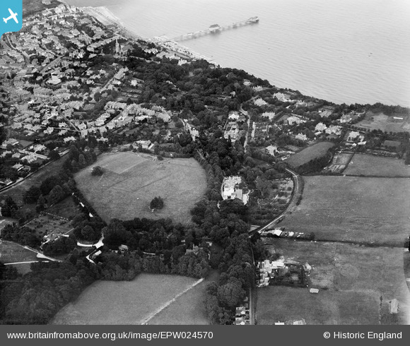
EPW024570 ENGLAND (1928). Big Meade Recreation Ground and environs, Shanklin, 1928
© Hawlfraint cyfranwyr OpenStreetMap a thrwyddedwyd gan yr OpenStreetMap Foundation. 2026. Trwyddedir y gartograffeg fel CC BY-SA.
Delweddau cyfagos (20)
Manylion
| Pennawd | [EPW024570] Big Meade Recreation Ground and environs, Shanklin, 1928 |
| Cyfeirnod | EPW024570 |
| Dyddiad | September-1928 |
| Dolen | |
| Enw lle | SHANKLIN |
| Plwyf | SHANKLIN |
| Ardal | |
| Gwlad | ENGLAND |
| Dwyreiniad / Gogleddiad | 458072, 80731 |
| Hydred / Lledred | -1.1789593874423, 50.622803649396 |
| Cyfeirnod Grid Cenedlaethol | SZ581807 |
Pinnau
Byddwch y cyntaf i ychwanegu sylw at y ddelwedd hon!


![[EPW024570] Big Meade Recreation Ground and environs, Shanklin, 1928](http://britainfromabove.org.uk/sites/all/libraries/aerofilms-images/public/100x100/EPW/024/EPW024570.jpg)
![[EPW024577] Big Meade Recreation Ground, Shanklin, 1928](http://britainfromabove.org.uk/sites/all/libraries/aerofilms-images/public/100x100/EPW/024/EPW024577.jpg)
![[EPW024571] Big Meade Recreation Ground and the town, Shanklin, 1928](http://britainfromabove.org.uk/sites/all/libraries/aerofilms-images/public/100x100/EPW/024/EPW024571.jpg)
![[EPW024566] Big Meade Recreation Ground and Upper Chine House, Shanklin, 1928](http://britainfromabove.org.uk/sites/all/libraries/aerofilms-images/public/100x100/EPW/024/EPW024566.jpg)
![[EPW024567] Big Meade Recreation Ground and the town, Shanklin, 1928](http://britainfromabove.org.uk/sites/all/libraries/aerofilms-images/public/100x100/EPW/024/EPW024567.jpg)
![[EPW024569] Big Meade Recreation Ground and environs, Shanklin, 1928](http://britainfromabove.org.uk/sites/all/libraries/aerofilms-images/public/100x100/EPW/024/EPW024569.jpg)
![[EPW022909] Upper Chine Girls School, Shanklin, 1928](http://britainfromabove.org.uk/sites/all/libraries/aerofilms-images/public/100x100/EPW/022/EPW022909.jpg)
![[EPW022904] Upper Chine Girls School, Shanklin, 1928](http://britainfromabove.org.uk/sites/all/libraries/aerofilms-images/public/100x100/EPW/022/EPW022904.jpg)
![[EPW022908] Upper Chine Girls School, Shanklin, 1928](http://britainfromabove.org.uk/sites/all/libraries/aerofilms-images/public/100x100/EPW/022/EPW022908.jpg)
![[EPW024565] Big Meade Recreation Ground, Shanklin, 1928](http://britainfromabove.org.uk/sites/all/libraries/aerofilms-images/public/100x100/EPW/024/EPW024565.jpg)
![[EPW024572] Big Meade Recreation Ground and surroundings, Shanklin, 1928](http://britainfromabove.org.uk/sites/all/libraries/aerofilms-images/public/100x100/EPW/024/EPW024572.jpg)
![[EPW024575] Big Meade Recreation Ground and surroundings, Shanklin, 1928](http://britainfromabove.org.uk/sites/all/libraries/aerofilms-images/public/100x100/EPW/024/EPW024575.jpg)
![[EPW022906] Upper Chine Girls School, Shanklin, 1928](http://britainfromabove.org.uk/sites/all/libraries/aerofilms-images/public/100x100/EPW/022/EPW022906.jpg)
![[EPW024576] Big Meade Recreation Ground and surroundings, Shanklin, 1928](http://britainfromabove.org.uk/sites/all/libraries/aerofilms-images/public/100x100/EPW/024/EPW024576.jpg)
![[EPW022907] Upper Chine Girls School, Shanklin, 1928](http://britainfromabove.org.uk/sites/all/libraries/aerofilms-images/public/100x100/EPW/022/EPW022907.jpg)
![[EPW022905] Upper Chine Girls School, Shanklin, 1928](http://britainfromabove.org.uk/sites/all/libraries/aerofilms-images/public/100x100/EPW/022/EPW022905.jpg)
![[EPW024574] Upper Chine House and the town, Shanklin, 1928](http://britainfromabove.org.uk/sites/all/libraries/aerofilms-images/public/100x100/EPW/024/EPW024574.jpg)
![[EPW024568] Big Meade Recreation Ground and environs, Shanklin, 1928](http://britainfromabove.org.uk/sites/all/libraries/aerofilms-images/public/100x100/EPW/024/EPW024568.jpg)
![[EPW024573] Big Meade Recreation Ground and Upper Chine House, Shanklin, 1928](http://britainfromabove.org.uk/sites/all/libraries/aerofilms-images/public/100x100/EPW/024/EPW024573.jpg)
![[EPW039649] Sandown Bay and the town, Shanklin, from the south-west, 1932](http://britainfromabove.org.uk/sites/all/libraries/aerofilms-images/public/100x100/EPW/039/EPW039649.jpg)