
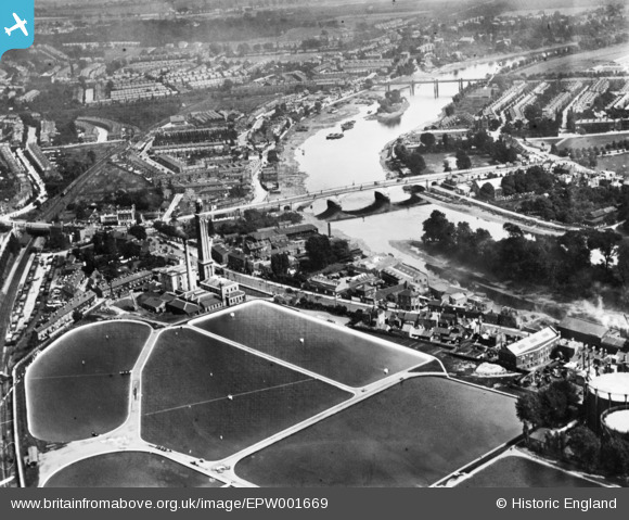
EPW001669 ENGLAND (1920). Kew Bridge and Kew Bridge Water Works, Brentford, 1920. This image has been produced from a print.
© Hawlfraint cyfranwyr OpenStreetMap a thrwyddedwyd gan yr OpenStreetMap Foundation. 2026. Trwyddedir y gartograffeg fel CC BY-SA.
Delweddau cyfagos (7)
EPW001669

EPW059344

EPW059940

EAW042755

EPW001717

EAW042756
, Kew, 1952. This image has been produced from a damaged negative.")
EPW057062

Manylion
| Pennawd | [EPW001669] Kew Bridge and Kew Bridge Water Works, Brentford, 1920. This image has been produced from a print. |
| Cyfeirnod | EPW001669 |
| Dyddiad | June-1920 |
| Dolen | |
| Enw lle | BRENTFORD |
| Plwyf | |
| Ardal | |
| Gwlad | ENGLAND |
| Dwyreiniad / Gogleddiad | 518842, 177936 |
| Hydred / Lledred | -0.28814479032152, 51.48738477483 |
| Cyfeirnod Grid Cenedlaethol | TQ188779 |
Pinnau

Resident Directors |
Saturday 10th of June 2023 01:27:20 PM | |

Leslie B |
Tuesday 19th of April 2022 01:55:43 PM | |
|
Leslie B |
Tuesday 19th of April 2022 01:54:57 PM | |
|
Leslie B |
Tuesday 19th of April 2022 01:54:12 PM | |

Des Elmes |
Saturday 30th of April 2016 08:13:58 PM | |
|
Des Elmes |
Saturday 30th of April 2016 08:11:25 PM | |
 |
Leslie B |
Monday 4th of April 2016 12:16:26 AM |
|
Leslie B |
Monday 4th of April 2016 12:05:55 AM |