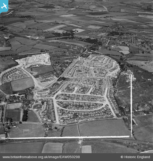
EAW050298 ENGLAND (1953). Council estate at Chickenley, Dewsbury, 1953. This image was marked by Aerofilms Ltd for photo editing.
    © Hawlfraint cyfranwyr OpenStreetMap a thrwyddedwyd gan yr OpenStreetMap Foundation. 2025. Trwyddedir y gartograffeg fel CC BY-SA.
  
Delweddau cyfagos (8)
Manylion
| Pennawd | [EAW050298] Council estate at Chickenley, Dewsbury, 1953. This image was marked by Aerofilms Ltd for photo editing. | 
| Cyfeirnod | EAW050298 | 
| Dyddiad | 3-July-1953 | 
| Dolen | |
| Enw lle | DEWSBURY | 
| Plwyf | |
| Ardal | |
| Gwlad | ENGLAND | 
| Dwyreiniad / Gogleddiad | 426587, 421305 | 
| Hydred / Lledred | -1.5973697299478, 53.687292831434 | 
| Cyfeirnod Grid Cenedlaethol | SE266213 | 
 
             
  ![[EAW050298] Council estate at Chickenley, Dewsbury, 1953. This image was marked by Aerofilms Ltd for photo editing.](http://britainfromabove.org.uk/sites/all/libraries/aerofilms-images/public/100x100/EAW/050/EAW050298.jpg) 
  
                                          ![[EAW050294] Council estate at Chickenley, Dewsbury, 1953. This image was marked by Aerofilms Ltd for photo editing.](http://britainfromabove.org.uk/sites/all/libraries/aerofilms-images/public/100x100/EAW/050/EAW050294.jpg) 
 ![[EAW050297] Council estate at Chickenley, Dewsbury, 1953. This image was marked by Aerofilms Ltd for photo editing.](http://britainfromabove.org.uk/sites/all/libraries/aerofilms-images/public/100x100/EAW/050/EAW050297.jpg) 
 ![[EAW050299] Council estate at Chickenley, Dewsbury, 1953. This image was marked by Aerofilms Ltd for photo editing.](http://britainfromabove.org.uk/sites/all/libraries/aerofilms-images/public/100x100/EAW/050/EAW050299.jpg) 
 ![[EAW050295] Council estate at Chickenley, Dewsbury, 1953. This image was marked by Aerofilms Ltd for photo editing.](http://britainfromabove.org.uk/sites/all/libraries/aerofilms-images/public/100x100/EAW/050/EAW050295.jpg) 
 ![[EAW050301] Council estate at Chickenley, Dewsbury, 1953. This image was marked by Aerofilms Ltd for photo editing.](http://britainfromabove.org.uk/sites/all/libraries/aerofilms-images/public/100x100/EAW/050/EAW050301.jpg) 
 ![[EAW050307] Housing estate under construction between Wakefield Road and the Chickenley Estate, Dewsbury, 1953. This image was marked by Aerofilms Ltd for photo editing.](http://britainfromabove.org.uk/sites/all/libraries/aerofilms-images/public/100x100/EAW/050/EAW050307.jpg) 
 ![[EAW050308] Housing estate under construction between Wakefield Road and the Chickenley Estate, Dewsbury, 1953. This image was marked by Aerofilms Ltd for photo editing.](http://britainfromabove.org.uk/sites/all/libraries/aerofilms-images/public/100x100/EAW/050/EAW050308.jpg) 
 
 Location of Chickenley Heath Railway Station (closed 1911)
 Location of Chickenley Heath Railway Station (closed 1911) 
