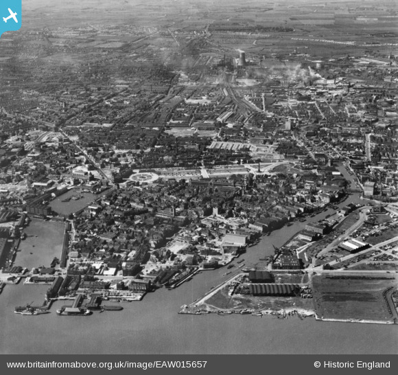
EAW015657 ENGLAND (1948). Humber Dock, the Old Harbour and city around Queen's Gardens, Kingston upon Hull, 1948. This image has been produced from a print.
© Hawlfraint cyfranwyr OpenStreetMap a thrwyddedwyd gan yr OpenStreetMap Foundation. 2026. Trwyddedir y gartograffeg fel CC BY-SA.
Delweddau cyfagos (12)
Manylion
| Pennawd | [EAW015657] Humber Dock, the Old Harbour and city around Queen's Gardens, Kingston upon Hull, 1948. This image has been produced from a print. |
| Cyfeirnod | EAW015657 |
| Dyddiad | 18-May-1948 |
| Dolen | |
| Enw lle | KINGSTON UPON HULL |
| Plwyf | |
| Ardal | |
| Gwlad | ENGLAND |
| Dwyreiniad / Gogleddiad | 509886, 428901 |
| Hydred / Lledred | -0.33356751719804, 53.744666063736 |
| Cyfeirnod Grid Cenedlaethol | TA099289 |
Pinnau

redmist |
Friday 15th of October 2021 07:20:27 PM | |

redmist |
Friday 15th of October 2021 07:17:19 PM | |

redmist |
Friday 15th of October 2021 07:16:19 PM | |

redmist |
Friday 15th of October 2021 07:16:02 PM | |

redmist |
Friday 15th of October 2021 07:15:26 PM | |

redmist |
Friday 15th of October 2021 07:14:46 PM | |

lipsee |
Thursday 30th of August 2018 11:46:28 AM | |

John Wass |
Wednesday 17th of June 2015 03:10:56 PM |


![[EAW015657] Humber Dock, the Old Harbour and city around Queen's Gardens, Kingston upon Hull, 1948. This image has been produced from a print.](http://britainfromabove.org.uk/sites/all/libraries/aerofilms-images/public/100x100/EAW/015/EAW015657.jpg)
![[EAW046135] Queen's Gardens and environs, Kingston upon Hull, 1952](http://britainfromabove.org.uk/sites/all/libraries/aerofilms-images/public/100x100/EAW/046/EAW046135.jpg)
![[EPW010792] The Guildhall alongside Queen's Dock, Kingston upon Hull, 1924. This image has been produced from a copy-negative.](http://britainfromabove.org.uk/sites/all/libraries/aerofilms-images/public/100x100/EPW/010/EPW010792.jpg)
![[EPW036503] The Queen's Dock, Guildhall and environs, Kingston upon Hull, 1931](http://britainfromabove.org.uk/sites/all/libraries/aerofilms-images/public/100x100/EPW/036/EPW036503.jpg)
![[EPW012813] The Guildhall, Kingston upon Hull, 1925](http://britainfromabove.org.uk/sites/all/libraries/aerofilms-images/public/100x100/EPW/012/EPW012813.jpg)
![[EPW036506] The Guildhall, Alfred Gelder Street and environs, Kingston upon Hulll, 1931](http://britainfromabove.org.uk/sites/all/libraries/aerofilms-images/public/100x100/EPW/036/EPW036506.jpg)
![[EPW012811] The junction of Savile Street and George Street, Kingston upon Hull, 1925](http://britainfromabove.org.uk/sites/all/libraries/aerofilms-images/public/100x100/EPW/012/EPW012811.jpg)
![[EPW036504] The Market Place, Holy Trinity Church and environs, Kingston upon Hull, 1931](http://britainfromabove.org.uk/sites/all/libraries/aerofilms-images/public/100x100/EPW/036/EPW036504.jpg)
![[EPW012805] Queen Victoria Square, Kingston upon Hull, 1925](http://britainfromabove.org.uk/sites/all/libraries/aerofilms-images/public/100x100/EPW/012/EPW012805.jpg)
![[EPW010788] City Hall, Queen's Dock and environs, Kingston upon Hull, 1924. This image has been produced from a copy-negative.](http://britainfromabove.org.uk/sites/all/libraries/aerofilms-images/public/100x100/EPW/010/EPW010788.jpg)
![[EPW036496] Prince's Dockand environs, Kingston upon Hull, 1931](http://britainfromabove.org.uk/sites/all/libraries/aerofilms-images/public/100x100/EPW/036/EPW036496.jpg)
![[EPW036497] Whitefriargate Bridge and Queen Victoria Square, Kingston upon Hull, 1931](http://britainfromabove.org.uk/sites/all/libraries/aerofilms-images/public/100x100/EPW/036/EPW036497.jpg)