
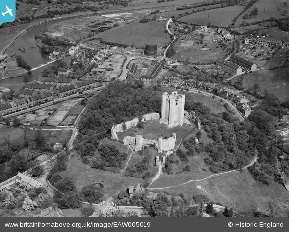
EAW005019 ENGLAND (1947). Conisbrough Castle, Conisbrough, 1947
© Hawlfraint cyfranwyr OpenStreetMap a thrwyddedwyd gan yr OpenStreetMap Foundation. 2026. Trwyddedir y gartograffeg fel CC BY-SA.
Delweddau cyfagos (6)
EAW005019

EAW005016

EAW005017

EAW005018

EAW005020

EPW014866

Manylion
| Pennawd | [EAW005019] Conisbrough Castle, Conisbrough, 1947 |
| Cyfeirnod | EAW005019 |
| Dyddiad | 7-May-1947 |
| Dolen | |
| Enw lle | CONISBROUGH |
| Plwyf | |
| Ardal | |
| Gwlad | ENGLAND |
| Dwyreiniad / Gogleddiad | 451502, 398953 |
| Hydred / Lledred | -1.223779265739, 53.484519447973 |
| Cyfeirnod Grid Cenedlaethol | SK515990 |
Pinnau

totoro |
Monday 14th of October 2013 10:46:27 AM | |
|
totoro |
Monday 14th of October 2013 10:45:05 AM | |
|
totoro |
Monday 14th of October 2013 10:44:21 AM | |
|
totoro |
Monday 14th of October 2013 10:43:47 AM | |
|
totoro |
Monday 14th of October 2013 10:43:05 AM | |
|
totoro |
Monday 14th of October 2013 10:42:21 AM | |
|
totoro |
Monday 14th of October 2013 10:41:54 AM | |
|
totoro |
Monday 14th of October 2013 10:41:30 AM | |
|
totoro |
Monday 14th of October 2013 10:40:55 AM | |
|
totoro |
Monday 14th of October 2013 10:39:53 AM |