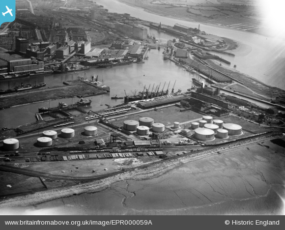
epr000059a ENGLAND (1934). Royal Edward Dock, Avonmouth, 1934. This image has been affected by flare.
© Copyright OpenStreetMap contributors and licensed by the OpenStreetMap Foundation. 2024. Cartography is licensed as CC BY-SA.
Nearby Images (18)
Details
| Title | [EPR000059A] Royal Edward Dock, Avonmouth, 1934. This image has been affected by flare. |
| Reference | EPR000059A |
| Date | 4-July-1934 |
| Link | |
| Place name | AVONMOUTH |
| Parish | |
| District | |
| Country | ENGLAND |
| Easting / Northing | 350898, 178919 |
| Longitude / Latitude | -2.7075656521045, 51.506584149346 |
| National Grid Reference | ST509789 |
Pins
Be the first to add a comment to this image!


![[EPR000059A] Royal Edward Dock, Avonmouth, 1934. This image has been affected by flare.](http://britainfromabove.org.uk/sites/all/libraries/aerofilms-images/public/100x100/EPR/000/EPR000059A.jpg)
![[EAW002255] The Port of Bristol Authority Royal Edward Docks, Avonmouth, 1946](http://britainfromabove.org.uk/sites/all/libraries/aerofilms-images/public/100x100/EAW/002/EAW002255.jpg)
![[EPW005493] The Royal Edward Dock, Avonmouth, 1921](http://britainfromabove.org.uk/sites/all/libraries/aerofilms-images/public/100x100/EPW/005/EPW005493.jpg)
![[EPR000075] Avonmouth Docks, Avonmouth, 1934](http://britainfromabove.org.uk/sites/all/libraries/aerofilms-images/public/100x100/EPR/000/EPR000075.jpg)
![[EPW005500] The Royal Edward Dock, Avonmouth, 1921](http://britainfromabove.org.uk/sites/all/libraries/aerofilms-images/public/100x100/EPW/005/EPW005500.jpg)
![[EPW005508] The Entrance Lock, Pumping Station and Royal Edward Dock, Avonmouth, 1921. This image has been produced from a copy-negative.](http://britainfromabove.org.uk/sites/all/libraries/aerofilms-images/public/100x100/EPW/005/EPW005508.jpg)
![[EPW005492] The Graving Dock, Pumping Station and Royal Edward Dock, Avonmouth, 1921](http://britainfromabove.org.uk/sites/all/libraries/aerofilms-images/public/100x100/EPW/005/EPW005492.jpg)
![[EPW005491] Fuel Storage Depot and the Timber Pond, Avonmouth, from the south-west, 1921](http://britainfromabove.org.uk/sites/all/libraries/aerofilms-images/public/100x100/EPW/005/EPW005491.jpg)
![[EAW002249] The Port of Bristol Authority Royal Edward Docks, Avonmouth, 1946](http://britainfromabove.org.uk/sites/all/libraries/aerofilms-images/public/100x100/EAW/002/EAW002249.jpg)
![[EAW002058] The Royal Edward Dock, Avonmouth, 1946](http://britainfromabove.org.uk/sites/all/libraries/aerofilms-images/public/100x100/EAW/002/EAW002058.jpg)
![[EPW005502] The Royal Edward Dock, Avonmouth, from the south-west, 1921](http://britainfromabove.org.uk/sites/all/libraries/aerofilms-images/public/100x100/EPW/005/EPW005502.jpg)
![[EPW027952] Royal Edward Dock and environs, Avonmouth, 1929](http://britainfromabove.org.uk/sites/all/libraries/aerofilms-images/public/100x100/EPW/027/EPW027952.jpg)
![[EPW005494] Fuel Storage Depot and the Timber Pond, Avonmouth, 1921](http://britainfromabove.org.uk/sites/all/libraries/aerofilms-images/public/100x100/EPW/005/EPW005494.jpg)
![[EAW002059] Avonmouth Docks, Avonmouth, 1946. This image has been produced from a print.](http://britainfromabove.org.uk/sites/all/libraries/aerofilms-images/public/100x100/EAW/002/EAW002059.jpg)
![[EAW002060] The Royal Edward Dock, Avonmouth, 1946](http://britainfromabove.org.uk/sites/all/libraries/aerofilms-images/public/100x100/EAW/002/EAW002060.jpg)
![[EPW005497] Fuel Storage Depot and the Timber Pond, Avonmouth, 1921](http://britainfromabove.org.uk/sites/all/libraries/aerofilms-images/public/100x100/EPW/005/EPW005497.jpg)
![[EPW037152] Avonmouth Docks, Avonmouth, from the south-west, 1931. This image has been produced from a copy-negative.](http://britainfromabove.org.uk/sites/all/libraries/aerofilms-images/public/100x100/EPW/037/EPW037152.jpg)
![[EAW002247] The Port of Bristol Authority Royal Edward Docks, Avonmouth, 1946](http://britainfromabove.org.uk/sites/all/libraries/aerofilms-images/public/100x100/EAW/002/EAW002247.jpg)