
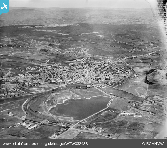
WPW032438 WALES (1930). View of Ebbw Vale, oblique aerial view. 5"x4" black and white glass plate negative.
© Copyright OpenStreetMap contributors and licensed by the OpenStreetMap Foundation. 2026. Cartography is licensed as CC BY-SA.
Nearby Images (12)
WPW032438

WPW032694

WPW032695

WPW032696

WPW032705

WPW032706

WPW032707

WPW049965

WPW049967

WPW049991

WPW049993

WPW049995

Details
| Title | [WPW032438] View of Ebbw Vale, oblique aerial view. 5"x4" black and white glass plate negative. |
| Reference | WPW032438 |
| Date | 1930 |
| Link | Coflein Archive Item 6370755 |
| Place name | |
| Parish | |
| District | |
| Country | WALES |
| Easting / Northing | 316800, 210000 |
| Longitude / Latitude | -3.2062224464759, 51.782019540859 |
| National Grid Reference | SO168100 |
Pins

Stewart Lawrie |
Monday 18th of September 2017 09:47:14 AM | |
|
swalian |
Saturday 26th of April 2014 01:18:46 PM | |
|
swalian |
Saturday 26th of April 2014 01:08:48 PM | |
|
swalian |
Saturday 26th of April 2014 01:08:04 PM | |
|
swalian |
Saturday 26th of April 2014 01:07:03 PM | |
|
swalian |
Saturday 26th of April 2014 01:06:33 PM | |

Class31 |
Thursday 16th of January 2014 05:08:13 PM | |
|
swalian |
Friday 7th of December 2012 01:53:21 AM | |
|
swalian |
Friday 7th of December 2012 01:52:38 AM | |
|
swalian |
Friday 7th of December 2012 01:51:08 AM | |
|
swalian |
Friday 7th of December 2012 01:48:25 AM | |
i don't think these are humphrey hughes houses they were more towards beaufort on the old dram road from winches town to beaufort |
judgejeffriesjones |
Wednesday 23rd of January 2013 05:20:04 PM |
|
swalian |
Tuesday 23rd of October 2012 04:15:57 AM | |
|
swalian |
Tuesday 23rd of October 2012 04:11:30 AM | |
|
swalian |
Tuesday 23rd of October 2012 04:07:19 AM | |
|
swalian |
Tuesday 23rd of October 2012 04:05:39 AM | |
|
judgejeffriesjones |
Saturday 11th of August 2012 09:17:08 PM | |
|
judgejeffriesjones |
Saturday 11th of August 2012 09:15:28 PM | |
|
judgejeffriesjones |
Saturday 11th of August 2012 09:14:08 PM | |
|
judgejeffriesjones |
Saturday 11th of August 2012 09:08:32 PM | |
Sorry but this isnt Alma St., it's actually Bailey St.. Alma St. is to the right finishing at the bottom of King Edward Rd.. |
elinia |
Wednesday 21st of November 2012 01:29:44 AM |
|
judgejeffriesjones |
Saturday 11th of August 2012 09:07:51 PM | |
Sorry again but I belive this to be Glamorgan St. |
elinia |
Wednesday 21st of November 2012 01:34:05 AM |
|
judgejeffriesjones |
Saturday 11th of August 2012 09:06:57 PM | |
|
judgejeffriesjones |
Saturday 11th of August 2012 08:59:16 PM | |
|
judgejeffriesjones |
Saturday 11th of August 2012 08:56:58 PM | |
The Catholic Church is about 100m north of this point - the 1st large building at approx 10 o'clock to this point. |
elinia |
Wednesday 21st of November 2012 01:43:49 AM |
|
judgejeffriesjones |
Saturday 11th of August 2012 08:55:38 PM | |
|
judgejeffriesjones |
Saturday 11th of August 2012 08:54:49 PM |

User Comment Contributions
brynmawr welfare grounds.winches town.old trinity church above pond.railway running from nant-y-glo to brynmawr station.beginning of warwick road to left.limestone road middle far right.and below to left is lyons row.railway station to the right top |
judgejeffriesjones |
Saturday 11th of August 2012 08:24:52 PM |
Brynmawr with Nant y Glo just in shot at centre right. |
swalian |
Tuesday 26th of June 2012 03:29:18 AM |