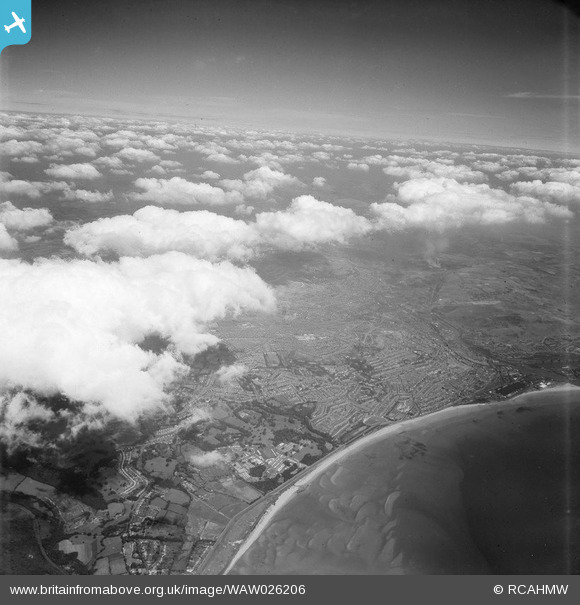
WAW026206 WALES (1949). View of Swansea from 10,000 ft
© Copyright OpenStreetMap contributors and licensed by the OpenStreetMap Foundation. 2026. Cartography is licensed as CC BY-SA.
Nearby Images (45)
Details
| Title | [WAW026206] View of Swansea from 10,000 ft |
| Reference | WAW026206 |
| Date | 12-August-1949 |
| Link | Coflein Archive Item 6414142 |
| Place name | |
| Parish | |
| District | |
| Country | WALES |
| Easting / Northing | 265642, 193048 |
| Longitude / Latitude | -3.9409992857105, 51.619726442612 |
| National Grid Reference | SS656930 |
Pins
Be the first to add a comment to this image!


![[WAW026206] View of Swansea from 10,000 ft](http://britainfromabove.org.uk/sites/all/libraries/aerofilms-images/public/100x100/WAW/026/WAW026206.jpg)
![[WAW043973] View of Swansea showing Weaver & Co., Ltd. Mill](http://britainfromabove.org.uk/sites/all/libraries/aerofilms-images/public/100x100/WAW/043/WAW043973.jpg)
![[WAW043974] View of Swansea showing Weaver & Co., Ltd. Mill](http://britainfromabove.org.uk/sites/all/libraries/aerofilms-images/public/100x100/WAW/043/WAW043974.jpg)
![[WAW043975] View of Swansea showing Weaver & Co., Ltd. Mill](http://britainfromabove.org.uk/sites/all/libraries/aerofilms-images/public/100x100/WAW/043/WAW043975.jpg)
![[WAW043976] View of Swansea showing Weaver & Co., Ltd. Mill](http://britainfromabove.org.uk/sites/all/libraries/aerofilms-images/public/100x100/WAW/043/WAW043976.jpg)
![[WAW043977] View of Swansea showing Weaver & Co., Ltd. Mill](http://britainfromabove.org.uk/sites/all/libraries/aerofilms-images/public/100x100/WAW/043/WAW043977.jpg)
![[WAW043978] View of Swansea showing Weaver & Co., Ltd. Mill](http://britainfromabove.org.uk/sites/all/libraries/aerofilms-images/public/100x100/WAW/043/WAW043978.jpg)
![[WAW043979] View of Swansea showing Weaver & Co., Ltd. Mill](http://britainfromabove.org.uk/sites/all/libraries/aerofilms-images/public/100x100/WAW/043/WAW043979.jpg)
![[WAW043980] View of Swansea showing Weaver & Co., Ltd. Mill](http://britainfromabove.org.uk/sites/all/libraries/aerofilms-images/public/100x100/WAW/043/WAW043980.jpg)
![[WAW043981] View of Swansea showing Weaver & Co., Ltd. Mill](http://britainfromabove.org.uk/sites/all/libraries/aerofilms-images/public/100x100/WAW/043/WAW043981.jpg)
![[WPW001054] View of Swansea showing Swansea and Mumbles railway and Victoria Park, oblique aerial view. 5"x4" black and white glass plate negative.](http://britainfromabove.org.uk/sites/all/libraries/aerofilms-images/public/100x100/WPW/001/WPW001054.jpg)
![[WPW001058] General view of Swansea, oblique aerial view. 5"x4" black and white glass plate negative.](http://britainfromabove.org.uk/sites/all/libraries/aerofilms-images/public/100x100/WPW/001/WPW001058.jpg)
![[WPW001074] General view of Swansea, oblique aerial view. 5"x4" black and white glass plate negative.](http://britainfromabove.org.uk/sites/all/libraries/aerofilms-images/public/100x100/WPW/001/WPW001074.jpg)
![[WPW006110] View of Swansea showing the docks and part of town centre, oblique aerial view. 5"x4" black and white glass plate negative.](http://britainfromabove.org.uk/sites/all/libraries/aerofilms-images/public/100x100/WPW/006/WPW006110.jpg)
![[WPW006111] View of Swansea showing Vetch football ground with match in progress, and the prison, oblique aerial view. 5"x4" black and white glass plate negative.](http://britainfromabove.org.uk/sites/all/libraries/aerofilms-images/public/100x100/WPW/006/WPW006111.jpg)
![[WPW006114] View of Swansea showing the gas works, Victoria Station and Weaver and Company's Flour Mills (distant right). Oblique aerial photograph, 5"x4" BW glass plate.](http://britainfromabove.org.uk/sites/all/libraries/aerofilms-images/public/100x100/WPW/006/WPW006114.jpg)
![[WPW006115] View of Swansea showing St Helen's sports ground with matches in progress, oblique aerial view. 5"x4" black and white glass plate negative.](http://britainfromabove.org.uk/sites/all/libraries/aerofilms-images/public/100x100/WPW/006/WPW006115.jpg)
![[WPW006116] View of King's Dock, Swansea, oblique aerial view. 5"x4" black and white glass plate negative.](http://britainfromabove.org.uk/sites/all/libraries/aerofilms-images/public/100x100/WPW/006/WPW006116.jpg)
![[WPW007672] View of Swansea showing King's dock, oblique aerial view. 5"x4" black and white glass plate negative.](http://britainfromabove.org.uk/sites/all/libraries/aerofilms-images/public/100x100/WPW/007/WPW007672.jpg)
![[WPW008831] View of Swansea showing docks, oblique aerial view. 5"x4" black and white glass plate negative.](http://britainfromabove.org.uk/sites/all/libraries/aerofilms-images/public/100x100/WPW/008/WPW008831.jpg)
![[WPW008832] View of Swansea showing centre of town and docks, oblique aerial view. 5"x4" black and white glass plate negative.](http://britainfromabove.org.uk/sites/all/libraries/aerofilms-images/public/100x100/WPW/008/WPW008832.jpg)
![[WPW008833] View of Swansea showing St Mary's Church and town centre, oblique aerial view. 5"x4" black and white glass plate negative.](http://britainfromabove.org.uk/sites/all/libraries/aerofilms-images/public/100x100/WPW/008/WPW008833.jpg)
![[WPW008834] View of Swansea showing docks, oblique aerial view. 5"x4" black and white glass plate negative.](http://britainfromabove.org.uk/sites/all/libraries/aerofilms-images/public/100x100/WPW/008/WPW008834.jpg)
![[WPW008836] View of Swansea showing St Mary's Church and town centre, oblique aerial view. 5"x4" black and white glass plate negative.](http://britainfromabove.org.uk/sites/all/libraries/aerofilms-images/public/100x100/WPW/008/WPW008836.jpg)
![[WPW008837] View of Swansea showing Swansea Infirmary and Uplands Community, oblique aerial view. 5"x4" black and white glass plate negative.](http://britainfromabove.org.uk/sites/all/libraries/aerofilms-images/public/100x100/WPW/008/WPW008837.jpg)
![[WPW029730] General view of Swansea, residential areas, oblique aerial view. 5"x4" black and white glass plate negative.](http://britainfromabove.org.uk/sites/all/libraries/aerofilms-images/public/100x100/WPW/029/WPW029730.jpg)
![[WPW029733] General view of Swansea, showing Vetch field, oblique aerial view. 5"x4" black and white glass plate negative.](http://britainfromabove.org.uk/sites/all/libraries/aerofilms-images/public/100x100/WPW/029/WPW029733.jpg)
![[WPW029736] Distant view of Swansea, oblique aerial view. 5"x4" black and white glass plate negative.](http://britainfromabove.org.uk/sites/all/libraries/aerofilms-images/public/100x100/WPW/029/WPW029736.jpg)
![[WPW029745] View of residential areas of Swansea, oblique aerial view. 5"x4" black and white glass plate negative.](http://britainfromabove.org.uk/sites/all/libraries/aerofilms-images/public/100x100/WPW/029/WPW029745.jpg)
![[WPW029748] View of residential areas of Swansea, oblique aerial view. 5"x4" black and white glass plate negative.](http://britainfromabove.org.uk/sites/all/libraries/aerofilms-images/public/100x100/WPW/029/WPW029748.jpg)
![[WPW049340] View of Swansea showing docks. Oblique aerial photograph, 5"x4" BW glass plate.](http://britainfromabove.org.uk/sites/all/libraries/aerofilms-images/public/100x100/WPW/049/WPW049340.jpg)
![[WPW054868] General view of Swansea, oblique aerial view. 5"x4" black and white glass plate negative.](http://britainfromabove.org.uk/sites/all/libraries/aerofilms-images/public/100x100/WPW/054/WPW054868.jpg)
![[WPW054869] General view of Swansea, oblique aerial view. 5"x4" black and white glass plate negative.](http://britainfromabove.org.uk/sites/all/libraries/aerofilms-images/public/100x100/WPW/054/WPW054869.jpg)
![[WPW054870] General view of Swansea, oblique aerial view. 5"x4" black and white glass plate negative.](http://britainfromabove.org.uk/sites/all/libraries/aerofilms-images/public/100x100/WPW/054/WPW054870.jpg)
![[WPW054871] View of Swansea, oblique aerial view. 5"x4" black and white glass plate negative.](http://britainfromabove.org.uk/sites/all/libraries/aerofilms-images/public/100x100/WPW/054/WPW054871.jpg)
![[WPW054872] General view of Swansea showing docks, oblique aerial view. 5"x4" black and white glass plate negative.](http://britainfromabove.org.uk/sites/all/libraries/aerofilms-images/public/100x100/WPW/054/WPW054872.jpg)
![[WPW054874] View of St Thomas and Dan-y-Graig areas of Swansea showing cemetery and Jersey Park, oblique aerial view. 5"x4" black and white glass plate negative.](http://britainfromabove.org.uk/sites/all/libraries/aerofilms-images/public/100x100/WPW/054/WPW054874.jpg)
![[WPW054876] View of central Swansea showing the Hospital and Vetch Field, oblique aerial view. 5"x4" black and white glass plate negative.](http://britainfromabove.org.uk/sites/all/libraries/aerofilms-images/public/100x100/WPW/054/WPW054876.jpg)
![[WPW054877] View of central Swansea showing Civic Centre and Victoria Park, oblique aerial view. 5"x4" black and white glass plate negative.](http://britainfromabove.org.uk/sites/all/libraries/aerofilms-images/public/100x100/WPW/054/WPW054877.jpg)
![[WPW054878] View of central Swansea, oblique aerial view. 5"x4" black and white glass plate negative.](http://britainfromabove.org.uk/sites/all/libraries/aerofilms-images/public/100x100/WPW/054/WPW054878.jpg)
![[WPW054879] View of central Swansea, oblique aerial view. 5"x4" black and white glass plate negative.](http://britainfromabove.org.uk/sites/all/libraries/aerofilms-images/public/100x100/WPW/054/WPW054879.jpg)
![[WPW054880] Distant view of Swansea, oblique aerial view. 5"x4" black and white glass plate negative.](http://britainfromabove.org.uk/sites/all/libraries/aerofilms-images/public/100x100/WPW/054/WPW054880.jpg)
![[WPW054902] View of central Swansea showing covered market, oblique aerial view. 5"x4" black and white glass plate negative.](http://britainfromabove.org.uk/sites/all/libraries/aerofilms-images/public/100x100/WPW/054/WPW054902.jpg)
![[WPW029742] View of St Marys church, Swansea, oblique aerial view. 5"x4" black and white glass plate negative.](http://britainfromabove.org.uk/sites/all/libraries/aerofilms-images/public/100x100/WPW/029/WPW029742.jpg)
![[WPW029747] View of Market Hall, Swansea, oblique aerial view. 5"x4" black and white glass plate negative.](http://britainfromabove.org.uk/sites/all/libraries/aerofilms-images/public/100x100/WPW/029/WPW029747.jpg)