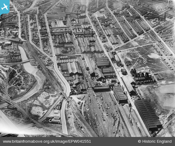
EPW041551 ENGLAND (1933). The Atlas & Norfolk Steel Works, Grimesthorpe, 1933
© Copyright OpenStreetMap contributors and licensed by the OpenStreetMap Foundation. 2026. Cartography is licensed as CC BY-SA.
Nearby Images (17)
Details
| Title | [EPW041551] The Atlas & Norfolk Steel Works, Grimesthorpe, 1933 |
| Reference | EPW041551 |
| Date | June-1933 |
| Link | |
| Place name | GRIMESTHORPE |
| Parish | |
| District | |
| Country | ENGLAND |
| Easting / Northing | 437088, 389094 |
| Longitude / Latitude | -1.4421706933257, 53.397109084605 |
| National Grid Reference | SK371891 |
Pins

circloy |
Sunday 5th of February 2023 08:13:51 PM | |

Class31 |
Monday 20th of July 2015 12:04:45 PM | |

Class31 |
Monday 20th of July 2015 12:02:55 PM | |

Class31 |
Monday 20th of July 2015 12:02:33 PM | |

oldbiker |
Monday 2nd of March 2015 01:18:12 AM | |

oldbiker |
Monday 2nd of March 2015 01:17:15 AM | |

oldbiker |
Monday 2nd of March 2015 01:16:32 AM | |

oldbiker |
Monday 2nd of March 2015 01:15:54 AM | |

oldbiker |
Monday 2nd of March 2015 01:15:20 AM | |

oldbiker |
Monday 2nd of March 2015 01:12:20 AM |


![[EPW041551] The Atlas & Norfolk Steel Works, Grimesthorpe, 1933](http://britainfromabove.org.uk/sites/all/libraries/aerofilms-images/public/100x100/EPW/041/EPW041551.jpg)
![[EPW041552] The Atlas & Norfolk Steel Works and environs, Grimesthorpe, 1933](http://britainfromabove.org.uk/sites/all/libraries/aerofilms-images/public/100x100/EPW/041/EPW041552.jpg)
![[EPW007795] The Atlas and Norfolk Steel Works, Sheffield, 1922](http://britainfromabove.org.uk/sites/all/libraries/aerofilms-images/public/100x100/EPW/007/EPW007795.jpg)
![[EPW041548] The Atlas & Norfolk Steel Works and environs, Grimesthorpe, 1933](http://britainfromabove.org.uk/sites/all/libraries/aerofilms-images/public/100x100/EPW/041/EPW041548.jpg)
![[EAW009650] The Atlas and Norfolk Steel Works, Sheffield, 1947](http://britainfromabove.org.uk/sites/all/libraries/aerofilms-images/public/100x100/EAW/009/EAW009650.jpg)
![[EPW041550] The Atlas & Norfolk Steel Works, Grimesthorpe, 1933](http://britainfromabove.org.uk/sites/all/libraries/aerofilms-images/public/100x100/EPW/041/EPW041550.jpg)
![[EPW041549] The Atlas & Norfolk Steel Works, Grimesthorpe, 1933](http://britainfromabove.org.uk/sites/all/libraries/aerofilms-images/public/100x100/EPW/041/EPW041549.jpg)
![[EAW009644] The Atlas and Norfolk Steel Works, Sheffield, 1947](http://britainfromabove.org.uk/sites/all/libraries/aerofilms-images/public/100x100/EAW/009/EAW009644.jpg)
![[EAW009659] The Atlas and Norfolk Steel Works, Sheffield, 1947](http://britainfromabove.org.uk/sites/all/libraries/aerofilms-images/public/100x100/EAW/009/EAW009659.jpg)
![[EAW009654] The Atlas and Norfolk Steel Works, Sheffield, 1947](http://britainfromabove.org.uk/sites/all/libraries/aerofilms-images/public/100x100/EAW/009/EAW009654.jpg)
![[EPW041547] The Atlas & Norfolk Steel Works and environs, Grimesthorpe, 1933](http://britainfromabove.org.uk/sites/all/libraries/aerofilms-images/public/100x100/EPW/041/EPW041547.jpg)
![[EAW018768] The Firth-Vickers Stainless Steels Ltd Atlas Works on Carlisle Street East, Grimesthorpe, 1948](http://britainfromabove.org.uk/sites/all/libraries/aerofilms-images/public/100x100/EAW/018/EAW018768.jpg)
![[EAW018765] The Firth-Vickers Stainless Steels Ltd Atlas Works on Carlisle Street East, Grimesthorpe, 1948. This image was marked by Aerofilms Ltd for photo editing.](http://britainfromabove.org.uk/sites/all/libraries/aerofilms-images/public/100x100/EAW/018/EAW018765.jpg)
![[EPW041546] The Atlas & Norfolk Steel Works and environs, Grimesthorpe, 1933](http://britainfromabove.org.uk/sites/all/libraries/aerofilms-images/public/100x100/EPW/041/EPW041546.jpg)
![[EAW009643] The Atlas and Norfolk Steel Works, Sheffield, 1947](http://britainfromabove.org.uk/sites/all/libraries/aerofilms-images/public/100x100/EAW/009/EAW009643.jpg)
![[EAW018767] The Firth-Vickers Stainless Steels Ltd Atlas Works on Carlisle Street East, Grimesthorpe, 1948. This image was marked by Aerofilms Ltd for photo editing.](http://britainfromabove.org.uk/sites/all/libraries/aerofilms-images/public/100x100/EAW/018/EAW018767.jpg)
![[EAW009648] The Atlas and Norfolk Steel Works, Sheffield, 1947](http://britainfromabove.org.uk/sites/all/libraries/aerofilms-images/public/100x100/EAW/009/EAW009648.jpg)