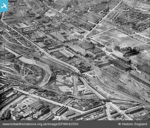
EPW041550 ENGLAND (1933). The Atlas & Norfolk Steel Works, Grimesthorpe, 1933
© Copyright OpenStreetMap contributors and licensed by the OpenStreetMap Foundation. 2026. Cartography is licensed as CC BY-SA.
Nearby Images (15)
Details
| Title | [EPW041550] The Atlas & Norfolk Steel Works, Grimesthorpe, 1933 |
| Reference | EPW041550 |
| Date | June-1933 |
| Link | |
| Place name | GRIMESTHORPE |
| Parish | |
| District | |
| Country | ENGLAND |
| Easting / Northing | 437190, 389114 |
| Longitude / Latitude | -1.4406342649273, 53.397281691901 |
| National Grid Reference | SK372891 |
Pins

Class31 |
Tuesday 21st of July 2015 10:11:20 AM | |

Class31 |
Tuesday 21st of July 2015 10:09:20 AM | |

Class31 |
Tuesday 21st of July 2015 10:06:16 AM | |

travellingpass |
Friday 19th of December 2014 01:07:05 PM | |

travellingpass |
Friday 19th of December 2014 01:02:43 PM |


![[EPW041550] The Atlas & Norfolk Steel Works, Grimesthorpe, 1933](http://britainfromabove.org.uk/sites/all/libraries/aerofilms-images/public/100x100/EPW/041/EPW041550.jpg)
![[EAW009650] The Atlas and Norfolk Steel Works, Sheffield, 1947](http://britainfromabove.org.uk/sites/all/libraries/aerofilms-images/public/100x100/EAW/009/EAW009650.jpg)
![[EPW007795] The Atlas and Norfolk Steel Works, Sheffield, 1922](http://britainfromabove.org.uk/sites/all/libraries/aerofilms-images/public/100x100/EPW/007/EPW007795.jpg)
![[EPW041551] The Atlas & Norfolk Steel Works, Grimesthorpe, 1933](http://britainfromabove.org.uk/sites/all/libraries/aerofilms-images/public/100x100/EPW/041/EPW041551.jpg)
![[EPW041552] The Atlas & Norfolk Steel Works and environs, Grimesthorpe, 1933](http://britainfromabove.org.uk/sites/all/libraries/aerofilms-images/public/100x100/EPW/041/EPW041552.jpg)
![[EAW009654] The Atlas and Norfolk Steel Works, Sheffield, 1947](http://britainfromabove.org.uk/sites/all/libraries/aerofilms-images/public/100x100/EAW/009/EAW009654.jpg)
![[EPW041548] The Atlas & Norfolk Steel Works and environs, Grimesthorpe, 1933](http://britainfromabove.org.uk/sites/all/libraries/aerofilms-images/public/100x100/EPW/041/EPW041548.jpg)
![[EPW041546] The Atlas & Norfolk Steel Works and environs, Grimesthorpe, 1933](http://britainfromabove.org.uk/sites/all/libraries/aerofilms-images/public/100x100/EPW/041/EPW041546.jpg)
![[EPW041547] The Atlas & Norfolk Steel Works and environs, Grimesthorpe, 1933](http://britainfromabove.org.uk/sites/all/libraries/aerofilms-images/public/100x100/EPW/041/EPW041547.jpg)
![[EAW018768] The Firth-Vickers Stainless Steels Ltd Atlas Works on Carlisle Street East, Grimesthorpe, 1948](http://britainfromabove.org.uk/sites/all/libraries/aerofilms-images/public/100x100/EAW/018/EAW018768.jpg)
![[EAW009644] The Atlas and Norfolk Steel Works, Sheffield, 1947](http://britainfromabove.org.uk/sites/all/libraries/aerofilms-images/public/100x100/EAW/009/EAW009644.jpg)
![[EPW041549] The Atlas & Norfolk Steel Works, Grimesthorpe, 1933](http://britainfromabove.org.uk/sites/all/libraries/aerofilms-images/public/100x100/EPW/041/EPW041549.jpg)
![[EAW018767] The Firth-Vickers Stainless Steels Ltd Atlas Works on Carlisle Street East, Grimesthorpe, 1948. This image was marked by Aerofilms Ltd for photo editing.](http://britainfromabove.org.uk/sites/all/libraries/aerofilms-images/public/100x100/EAW/018/EAW018767.jpg)
![[EAW018765] The Firth-Vickers Stainless Steels Ltd Atlas Works on Carlisle Street East, Grimesthorpe, 1948. This image was marked by Aerofilms Ltd for photo editing.](http://britainfromabove.org.uk/sites/all/libraries/aerofilms-images/public/100x100/EAW/018/EAW018765.jpg)
![[EAW009659] The Atlas and Norfolk Steel Works, Sheffield, 1947](http://britainfromabove.org.uk/sites/all/libraries/aerofilms-images/public/100x100/EAW/009/EAW009659.jpg)