
EPW019732 ENGLAND (1927). Tamworth Castle and St Editha's Church, Tamworth, 1927

© Copyright OpenStreetMap contributors and licensed by the OpenStreetMap Foundation. 2026. Cartography is licensed as CC BY-SA.
Nearby Images (18)
EPW019732

EAW003617

EPW019731

EAW007509

EAW007511

EAW007508

EPW024630

EAW007512

EAW007510

EAW007514

EAW003618

EAW003616

EAW007513

EPW024634

EPW019733

EPW024637

EPW019734

EPW024636

Details
| Title | [EPW019732] Tamworth Castle and St Editha's Church, Tamworth, 1927 |
| Reference | EPW019732 |
| Date | 20-October-1927 |
| Link | |
| Place name | TAMWORTH |
| Parish | |
| District | |
| Country | ENGLAND |
| Easting / Northing | 420611, 303905 |
| Longitude / Latitude | -1.6954313097327, 52.632154930681 |
| National Grid Reference | SK206039 |
Pins

Chris Gibson |
Wednesday 10th of October 2018 11:29:52 PM | |
|
Chris Gibson |
Wednesday 10th of October 2018 11:29:10 PM | |
|
EMC |
Saturday 17th of August 2013 03:05:03 PM | |
|
Chris Gibson |
Monday 8th of October 2012 11:37:04 PM |
User Comment Contributions
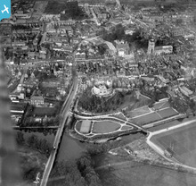
Another broad view covering many streets and landmarks in the town. |
Chris Gibson |
Tuesday 9th of October 2012 01:49:46 PM |