
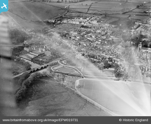
EPW019731 ENGLAND (1927). Lady Bridge and Tamworth Castle, Tamworth, 1927
© Copyright OpenStreetMap contributors and licensed by the OpenStreetMap Foundation. 2026. Cartography is licensed as CC BY-SA.
Nearby Images (18)
EPW019731

EAW007508

EPW019732

EPW024630

EAW007509

EAW003617

EAW007511

EAW007512

EAW007510

EAW007514

EAW003618

EAW003616

EAW007513

EPW024634

EPW019733

EPW024637

EPW019734

EPW024636

Details
| Title | [EPW019731] Lady Bridge and Tamworth Castle, Tamworth, 1927 |
| Reference | EPW019731 |
| Date | 20-October-1927 |
| Link | |
| Place name | TAMWORTH |
| Parish | |
| District | |
| Country | ENGLAND |
| Easting / Northing | 420606, 303898 |
| Longitude / Latitude | -1.6955056304727, 52.63209218603 |
| National Grid Reference | SK206039 |
Pins

Chris Gibson |
Monday 15th of October 2012 04:38:34 PM | |
|
Chris Gibson |
Monday 15th of October 2012 04:37:43 PM | |
|
Chris Gibson |
Monday 15th of October 2012 04:36:57 PM | |
|
Chris Gibson |
Monday 15th of October 2012 04:35:55 PM | |
|
Chris Gibson |
Monday 15th of October 2012 04:35:11 PM | |
|
Chris Gibson |
Monday 15th of October 2012 04:34:38 PM | |
|
Chris Gibson |
Monday 15th of October 2012 04:29:16 PM | |
|
Chris Gibson |
Monday 15th of October 2012 04:28:37 PM | |
|
Chris Gibson |
Monday 15th of October 2012 04:26:55 PM |
User Comment Contributions
This photograph show s a large area of The Leys near the town centre. |
Chris Gibson |
Monday 15th of October 2012 04:24:56 PM |