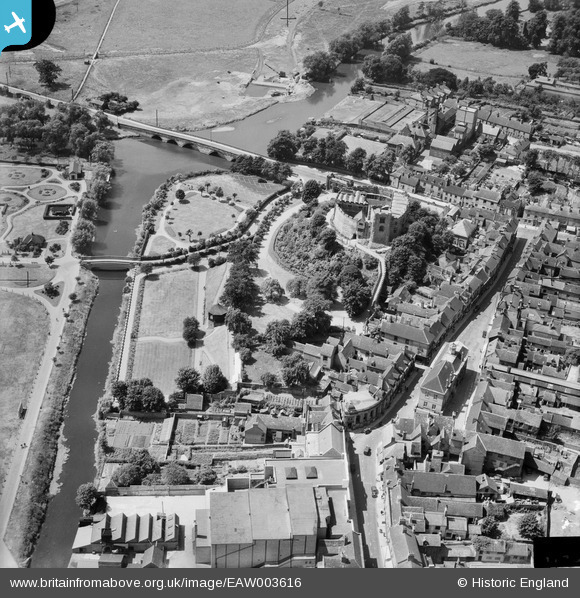
EAW003616 ENGLAND (1947). The castle and environs, Tamworth, 1947
© Copyright OpenStreetMap contributors and licensed by the OpenStreetMap Foundation. 2026. Cartography is licensed as CC BY-SA.
Nearby Images (18)
Details
| Title | [EAW003616] The castle and environs, Tamworth, 1947 |
| Reference | EAW003616 |
| Date | March-1947 |
| Link | |
| Place name | TAMWORTH |
| Parish | |
| District | |
| Country | ENGLAND |
| Easting / Northing | 420663, 303897 |
| Longitude / Latitude | -1.6946634184195, 52.632081027878 |
| National Grid Reference | SK207039 |
Pins

Chris Gibson |
Tuesday 9th of October 2018 12:56:48 PM | |

Andrew Sandars |
Tuesday 13th of January 2015 08:12:23 PM | |

MB |
Wednesday 2nd of October 2013 10:03:29 PM | |

MB |
Wednesday 2nd of October 2013 10:00:38 PM | |

MB |
Wednesday 2nd of October 2013 09:59:46 PM | |

MB |
Wednesday 2nd of October 2013 09:59:03 PM | |

MB |
Wednesday 2nd of October 2013 09:58:07 PM | |
As they are not working near a convenient source of electricity, I would expect this to be powered by an IC engine, so quite possible it's a Simplex. |

John W |
Saturday 18th of June 2016 10:38:22 PM |

MB |
Wednesday 2nd of October 2013 09:57:21 PM | |

MB |
Wednesday 2nd of October 2013 09:55:00 PM | |

MB |
Wednesday 2nd of October 2013 09:54:15 PM | |

MB |
Wednesday 2nd of October 2013 09:53:57 PM | |

MB |
Wednesday 2nd of October 2013 09:52:49 PM |
User Comment Contributions
Originally an eleventh century Norman motte and bailey castle. The twelfth century shell keep is shown to good advantage here. It was substantially altered between the sixteenth and nineteenth centuries. The building is listed Grade I |

MB |
Wednesday 2nd of October 2013 09:49:49 PM |


![[EAW003616] The castle and environs, Tamworth, 1947](http://britainfromabove.org.uk/sites/all/libraries/aerofilms-images/public/100x100/EAW/003/EAW003616.jpg)
![[EAW007510] Tamworth Castle, Tamworth, 1947](http://britainfromabove.org.uk/sites/all/libraries/aerofilms-images/public/100x100/EAW/007/EAW007510.jpg)
![[EAW007514] Tamworth Castle and environs, Tamworth, 1947. This image has been produced from a print.](http://britainfromabove.org.uk/sites/all/libraries/aerofilms-images/public/100x100/EAW/007/EAW007514.jpg)
![[EAW007512] Tamworth Castle, Tamworth, 1947. This image has been produced from a print.](http://britainfromabove.org.uk/sites/all/libraries/aerofilms-images/public/100x100/EAW/007/EAW007512.jpg)
![[EAW003617] The castle and environs, Tamworth, 1947](http://britainfromabove.org.uk/sites/all/libraries/aerofilms-images/public/100x100/EAW/003/EAW003617.jpg)
![[EAW007509] Tamworth Castle, Tamworth, 1947](http://britainfromabove.org.uk/sites/all/libraries/aerofilms-images/public/100x100/EAW/007/EAW007509.jpg)
![[EAW003618] The castle and environs, Tamworth, 1947](http://britainfromabove.org.uk/sites/all/libraries/aerofilms-images/public/100x100/EAW/003/EAW003618.jpg)
![[EPW019732] Tamworth Castle and St Editha's Church, Tamworth, 1927](http://britainfromabove.org.uk/sites/all/libraries/aerofilms-images/public/100x100/EPW/019/EPW019732.jpg)
![[EPW019731] Lady Bridge and Tamworth Castle, Tamworth, 1927](http://britainfromabove.org.uk/sites/all/libraries/aerofilms-images/public/100x100/EPW/019/EPW019731.jpg)
![[EAW007508] Tamworth Castle, Tamworth, 1947](http://britainfromabove.org.uk/sites/all/libraries/aerofilms-images/public/100x100/EAW/007/EAW007508.jpg)
![[EAW007511] Tamworth Castle, Tamworth, 1947. This image has been produced from a print.](http://britainfromabove.org.uk/sites/all/libraries/aerofilms-images/public/100x100/EAW/007/EAW007511.jpg)
![[EPW024630] Tamworth Castle and the town centre, Tamworth, 1928](http://britainfromabove.org.uk/sites/all/libraries/aerofilms-images/public/100x100/EPW/024/EPW024630.jpg)
![[EPW024637] The Market Place and Town Hall, Tamworth, 1928](http://britainfromabove.org.uk/sites/all/libraries/aerofilms-images/public/100x100/EPW/024/EPW024637.jpg)
![[EPW024634] Tamworth Castle and Park, Tamworth, 1928](http://britainfromabove.org.uk/sites/all/libraries/aerofilms-images/public/100x100/EPW/024/EPW024634.jpg)
![[EPW019733] Tamworth Castle and St Editha's Church, Tamworth, 1927](http://britainfromabove.org.uk/sites/all/libraries/aerofilms-images/public/100x100/EPW/019/EPW019733.jpg)
![[EAW007513] Lady Bridge and Tamworth Castle, Tamworth, 1947. This image has been produced from a print.](http://britainfromabove.org.uk/sites/all/libraries/aerofilms-images/public/100x100/EAW/007/EAW007513.jpg)
![[EPW019734] St Editha's Church and Church Street, Tamworth, 1927](http://britainfromabove.org.uk/sites/all/libraries/aerofilms-images/public/100x100/EPW/019/EPW019734.jpg)
![[EPW024636] St Editha's Church, Tamworth, 1928](http://britainfromabove.org.uk/sites/all/libraries/aerofilms-images/public/100x100/EPW/024/EPW024636.jpg)
