
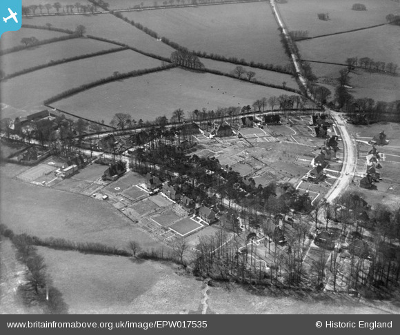
EPW017535 ENGLAND (1927). New housing at Pinnerhill Farm, Pinner, 1927
© Copyright OpenStreetMap contributors and licensed by the OpenStreetMap Foundation. 2025. Cartography is licensed as CC BY-SA.
Nearby Images (9)
EPW017535

EPW017530

EPW017529

EPW017534

EPW017536

EPW017528

EPW017532

EPW017533

EPW017531

Details
| Title | [EPW017535] New housing at Pinnerhill Farm, Pinner, 1927 |
| Reference | EPW017535 |
| Date | March-1927 |
| Link | |
| Place name | PINNER |
| Parish | |
| District | |
| Country | ENGLAND |
| Easting / Northing | 510975, 190975 |
| Longitude / Latitude | -0.39730176214002, 51.606190281405 |
| National Grid Reference | TQ110910 |
Pins
 Class31 |
Tuesday 18th of September 2012 10:51:36 AM | |
Class31 |
Tuesday 18th of September 2012 10:51:13 AM | |
Class31 |
Tuesday 18th of September 2012 10:32:21 AM | |
Class31 |
Tuesday 18th of September 2012 10:31:51 AM | |
Class31 |
Tuesday 18th of September 2012 10:30:36 AM |
User Comment Contributions
Pinner Hill Farm on the left this time. Hillside Road leads straight on to Potter Street which looks freshly concreted and maybe laid as a 'service' road for the new estate down to what is now the roundabout at Northwood Hills. The straightness of the road from Pinner Green to Northwood Kiln Farm comes from the time when it was built as a Toll Road to Rickmansworth. There was a tollgate at Pinner Green and one at the junction with Ducks Hill Road. The Gate Public House refers to the Toll Gate at this junction. The name Potter Street and Potter Street Hill refer to the 13th Century Pottery kiln close to the dip in Potter Street Hill. That dip 150 years ago was called 'Porridge Pot' - an attribution from the stickiness of the clay in very wet weather. Honeypot Lane is a similar derivation. |
 Harrow&Wembley |
Tuesday 3rd of July 2012 10:50:10 PM |