
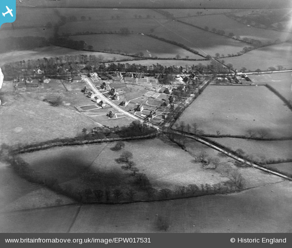
EPW017531 ENGLAND (1927). New housing at Pinnerhill Farm, Pinner, 1927
© Copyright OpenStreetMap contributors and licensed by the OpenStreetMap Foundation. 2024. Cartography is licensed as CC BY-SA.
Nearby Images (9)
EPW017531

EPW017533

EPW017536

EPW017532

EPW017528

EPW017530

EPW017529

EPW017535

EPW017534

Details
| Title | [EPW017531] New housing at Pinnerhill Farm, Pinner, 1927 |
| Reference | EPW017531 |
| Date | March-1927 |
| Link | |
| Place name | PINNER |
| Parish | |
| District | |
| Country | ENGLAND |
| Easting / Northing | 510812, 190992 |
| Longitude / Latitude | -0.39964944082492, 51.606375198423 |
| National Grid Reference | TQ108910 |
Pins
 Class31 |
Tuesday 18th of September 2012 11:10:10 AM |
User Comment Contributions
More accurate to label 'near' Pinner Hill Farm. The houses are part of the Pinner Hill private estate built by Griggs & Co. Centre image is the cross roads Potter Street and Potter Street Hill and Hillside Road on the estate. The road running left to right is Pinner Hill, which changes to Pinner Hill Road just to the left (in the image)of Pinner Hill Farm. The clock tower with barn attached sticks out 'over' the road. This has recently be named The Folly - a term originally applied to the house off Woodhall Drive also commissioned by Tooke in the 1860s. Behind the tower is a track which became the start of Albury Drive in the late 30s. The thin white line which continues is a footpath to Woodhall Farm. Beyond Pinner Hill (the road) is now Pinner Hill Golf Course, opened in 1928. All the properties here still exist except that Rondor House has been rebuilt as Mulberry House. |
 Harrow&Wembley |
Thursday 2nd of July 2015 07:32:09 PM |
A wonderful picture. I have hundreds of family photos of Pinner Hill Farm, and Woodhall Farm which were both owned by my Great Grandparents, and their parents. However, there are very few of the surrounding countryside to put them into context. What a great insight, and a glimpse into the past. |
sar63 |
Thursday 2nd of July 2015 07:32:09 PM |