
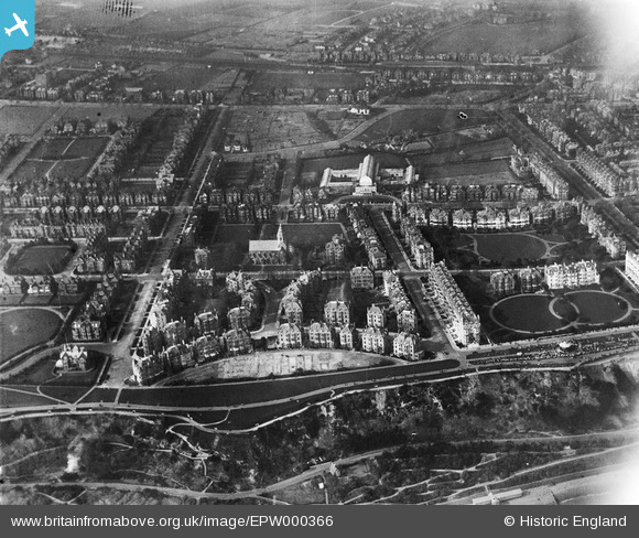
EPW000366 ENGLAND (1920). Clifton Crescent, Folkestone, 1920
© Copyright OpenStreetMap contributors and licensed by the OpenStreetMap Foundation. 2026. Cartography is licensed as CC BY-SA.
Nearby Images (15)
EPW000366

EAW024829

EPW000592

EPW000588

EPW000364

EPW000082

EAW002854

EPW000085

EPW000583

EAW002375

EPW009201

EAW002370

EAW002374

EPW000077

EAW024828

Details
| Title | [EPW000366] Clifton Crescent, Folkestone, 1920 |
| Reference | EPW000366 |
| Date | April-1920 |
| Link | |
| Place name | FOLKESTONE |
| Parish | FOLKESTONE |
| District | |
| Country | ENGLAND |
| Easting / Northing | 621990, 135607 |
| Longitude / Latitude | 1.1694603563575, 51.076244299629 |
| National Grid Reference | TR220356 |
Pins

Paolo |
Saturday 10th of November 2012 03:27:00 PM | |
|
Paolo |
Saturday 10th of November 2012 03:23:45 PM | |
|
Paolo |
Saturday 10th of November 2012 03:21:15 PM | |
|
Paolo |
Saturday 10th of November 2012 03:20:39 PM | |
|
Paolo |
Tuesday 10th of July 2012 05:21:41 PM | |
|
Paolo |
Tuesday 10th of July 2012 05:20:41 PM | |
|
Paolo |
Tuesday 10th of July 2012 05:17:32 PM | |
|
Paolo |
Tuesday 10th of July 2012 05:16:31 PM | |
|
Paolo |
Tuesday 10th of July 2012 05:13:54 PM |