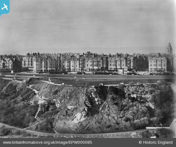
EPW000085 ENGLAND (1920). The Leas, Folkestone, 1920
© Copyright OpenStreetMap contributors and licensed by the OpenStreetMap Foundation. 2026. Cartography is licensed as CC BY-SA.
Nearby Images (13)
Details
| Title | [EPW000085] The Leas, Folkestone, 1920 |
| Reference | EPW000085 |
| Date | February-1920 |
| Link | |
| Place name | FOLKESTONE |
| Parish | FOLKESTONE |
| District | |
| Country | ENGLAND |
| Easting / Northing | 621931, 135415 |
| Longitude / Latitude | 1.1685014994328, 51.074543075407 |
| National Grid Reference | TR219354 |
Pins

Paolo |
Monday 14th of September 2015 09:39:04 PM | |

Paolo |
Monday 14th of September 2015 09:29:59 PM | |

Paolo |
Monday 3rd of December 2012 03:30:31 PM |
User Comment Contributions
Shows the western half of Clifton Crescent, withthe Manor House at far left and Holy Trinity Church at far right. But what is the cuboid structure opposite the gap in the buildings leading to the church? Is it left over from Rest Camp 3 in WW1? |

Paolo |
Wednesday 27th of June 2012 04:22:27 PM |


![[EPW000085] The Leas, Folkestone, 1920](http://britainfromabove.org.uk/sites/all/libraries/aerofilms-images/public/100x100/EPW/000/EPW000085.jpg)
![[EPW000583] Clifton Crescent, Folkestone, 1920](http://britainfromabove.org.uk/sites/all/libraries/aerofilms-images/public/100x100/EPW/000/EPW000583.jpg)
![[EPW000082] Clifton Crescent and Holy Trinity Church, Folkestone, 1920](http://britainfromabove.org.uk/sites/all/libraries/aerofilms-images/public/100x100/EPW/000/EPW000082.jpg)
![[EAW024829] Clifton Crescent and environs, Folkestone, 1949](http://britainfromabove.org.uk/sites/all/libraries/aerofilms-images/public/100x100/EAW/024/EAW024829.jpg)
![[EPW000592] Clifton Crescent and Westcliff, Folkestone, from the west, 1920](http://britainfromabove.org.uk/sites/all/libraries/aerofilms-images/public/100x100/EPW/000/EPW000592.jpg)
![[EAW024833] West Cliff, Folkestone, from the south-west, 1949](http://britainfromabove.org.uk/sites/all/libraries/aerofilms-images/public/100x100/EAW/024/EAW024833.jpg)
![[EPW000077] Cliff Railway, Folkestone, 1920](http://britainfromabove.org.uk/sites/all/libraries/aerofilms-images/public/100x100/EPW/000/EPW000077.jpg)
![[EAW002374] Clifton Crescent and The Leas, Folkestone, 1946](http://britainfromabove.org.uk/sites/all/libraries/aerofilms-images/public/100x100/EAW/002/EAW002374.jpg)
![[EAW002375] The Leas, Folkestone, 1946](http://britainfromabove.org.uk/sites/all/libraries/aerofilms-images/public/100x100/EAW/002/EAW002375.jpg)
![[EPW000366] Clifton Crescent, Folkestone, 1920](http://britainfromabove.org.uk/sites/all/libraries/aerofilms-images/public/100x100/EPW/000/EPW000366.jpg)
![[EPW009201] Clifton Gardens and The Leas, Folkestone, 1923](http://britainfromabove.org.uk/sites/all/libraries/aerofilms-images/public/100x100/EPW/009/EPW009201.jpg)
![[EAW002854] West Cliff, Clifton Gardens and the surrounding residential area, Folkestone, 1946](http://britainfromabove.org.uk/sites/all/libraries/aerofilms-images/public/100x100/EAW/002/EAW002854.jpg)
![[EPW000364] Clifton Gardens, Folkestone, 1920](http://britainfromabove.org.uk/sites/all/libraries/aerofilms-images/public/100x100/EPW/000/EPW000364.jpg)