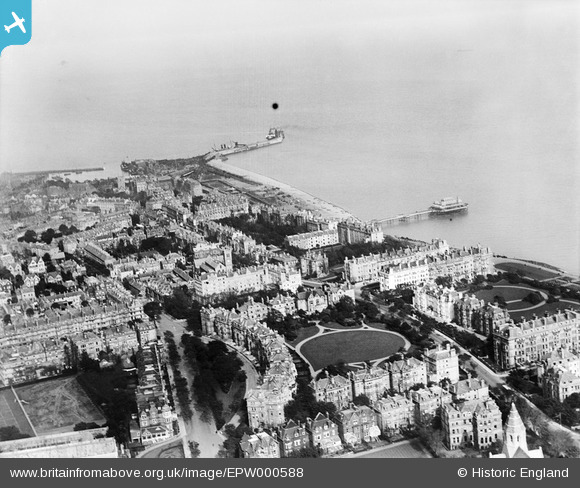
EPW000588 ENGLAND (1920). Augusta Gardens, Folkestone, from the north-west, 1920
© Copyright OpenStreetMap contributors and licensed by the OpenStreetMap Foundation. 2026. Cartography is licensed as CC BY-SA.
Nearby Images (12)
Details
| Title | [EPW000588] Augusta Gardens, Folkestone, from the north-west, 1920 |
| Reference | EPW000588 |
| Date | April-1920 |
| Link | |
| Place name | FOLKESTONE |
| Parish | FOLKESTONE |
| District | |
| Country | ENGLAND |
| Easting / Northing | 622136, 135688 |
| Longitude / Latitude | 1.1715912251991, 51.076915132396 |
| National Grid Reference | TR221357 |
Pins

John W |
Wednesday 12th of October 2016 10:09:06 AM |
User Comment Contributions
The paddler at berth no 1 must be the "Prins Hendrik" (1895-1922) inbound from Vlissingen. |

Martyn |
Monday 14th of July 2014 11:17:34 PM |


![[EPW000588] Augusta Gardens, Folkestone, from the north-west, 1920](http://britainfromabove.org.uk/sites/all/libraries/aerofilms-images/public/100x100/EPW/000/EPW000588.jpg)
![[EAW002370] The area between Clifton Gardens and Radnor Park, Folkestone, from the south, 1946](http://britainfromabove.org.uk/sites/all/libraries/aerofilms-images/public/100x100/EAW/002/EAW002370.jpg)
![[EPW000364] Clifton Gardens, Folkestone, 1920](http://britainfromabove.org.uk/sites/all/libraries/aerofilms-images/public/100x100/EPW/000/EPW000364.jpg)
![[EAW002854] West Cliff, Clifton Gardens and the surrounding residential area, Folkestone, 1946](http://britainfromabove.org.uk/sites/all/libraries/aerofilms-images/public/100x100/EAW/002/EAW002854.jpg)
![[EAW002855] Leas Cliff Hall, Clifton Gardens and the surrounding residential area, Folkestone, 1946](http://britainfromabove.org.uk/sites/all/libraries/aerofilms-images/public/100x100/EAW/002/EAW002855.jpg)
![[EPW000366] Clifton Crescent, Folkestone, 1920](http://britainfromabove.org.uk/sites/all/libraries/aerofilms-images/public/100x100/EPW/000/EPW000366.jpg)
![[EAW024830] West Cliff, Folkestone, from the south-west, 1949](http://britainfromabove.org.uk/sites/all/libraries/aerofilms-images/public/100x100/EAW/024/EAW024830.jpg)
![[EAW024829] Clifton Crescent and environs, Folkestone, 1949](http://britainfromabove.org.uk/sites/all/libraries/aerofilms-images/public/100x100/EAW/024/EAW024829.jpg)
![[EPW000592] Clifton Crescent and Westcliff, Folkestone, from the west, 1920](http://britainfromabove.org.uk/sites/all/libraries/aerofilms-images/public/100x100/EPW/000/EPW000592.jpg)
![[EPW009197] The Clifton Gardens and The Leas, Folkestone, 1923](http://britainfromabove.org.uk/sites/all/libraries/aerofilms-images/public/100x100/EPW/009/EPW009197.jpg)
![[EPW009199] The Langhorne Gardens and The Leas, Folkestone, 1923](http://britainfromabove.org.uk/sites/all/libraries/aerofilms-images/public/100x100/EPW/009/EPW009199.jpg)
![[EPW035414] West Cliff, Clifton Gardens and the town, Folkestone, from the south, 1931](http://britainfromabove.org.uk/sites/all/libraries/aerofilms-images/public/100x100/EPW/035/EPW035414.jpg)