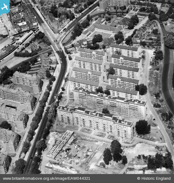
EAW044321 ENGLAND (1952). The Woodberry Down Estate between Seven Sisters Road and West Reservoir, Stamford Hill, 1952
© Copyright OpenStreetMap contributors and licensed by the OpenStreetMap Foundation. 2026. Cartography is licensed as CC BY-SA.
Nearby Images (33)
Details
| Title | [EAW044321] The Woodberry Down Estate between Seven Sisters Road and West Reservoir, Stamford Hill, 1952 |
| Reference | EAW044321 |
| Date | 24-June-1952 |
| Link | |
| Place name | STAMFORD HILL |
| Parish | |
| District | |
| Country | ENGLAND |
| Easting / Northing | 532629, 187754 |
| Longitude / Latitude | -0.085965240260753, 51.572557667606 |
| National Grid Reference | TQ326878 |
Pins

Kevin O'Leary |
Thursday 22nd of January 2015 12:22:54 PM | |

John Wass |
Monday 4th of August 2014 04:47:10 PM |


![[EAW044321] The Woodberry Down Estate between Seven Sisters Road and West Reservoir, Stamford Hill, 1952](http://britainfromabove.org.uk/sites/all/libraries/aerofilms-images/public/100x100/EAW/044/EAW044321.jpg)
![[EAW044327] The Woodberry Down Estate between Seven Sisters Road and East Reservoir, Stamford Hill, 1952](http://britainfromabove.org.uk/sites/all/libraries/aerofilms-images/public/100x100/EAW/044/EAW044327.jpg)
![[EAW044315] The Woodberry Down Estate between New River and East Reservoir, Stamford Hill, 1952](http://britainfromabove.org.uk/sites/all/libraries/aerofilms-images/public/100x100/EAW/044/EAW044315.jpg)
![[EAW044311] The Woodberry Down Estate between Seven Sisters Road and East Reservoir, Stamford Hill, 1952](http://britainfromabove.org.uk/sites/all/libraries/aerofilms-images/public/100x100/EAW/044/EAW044311.jpg)
![[EAW044325] The Woodberry Down Estate between New River and East Reservoir, Stamford Hill, 1952](http://britainfromabove.org.uk/sites/all/libraries/aerofilms-images/public/100x100/EAW/044/EAW044325.jpg)
![[EAW044316] The Woodberry Down Estate between New River and East Reservoir, Stamford Hill, 1952](http://britainfromabove.org.uk/sites/all/libraries/aerofilms-images/public/100x100/EAW/044/EAW044316.jpg)
![[EAW044314] Woodberry Down Primary School on Woodberry Grove and part of the Woodberry Down Estate under construction, Stamford Hill, 1952](http://britainfromabove.org.uk/sites/all/libraries/aerofilms-images/public/100x100/EAW/044/EAW044314.jpg)
![[EAW044326] The Woodberry Down Estate between New River and East Reservoir, Stamford Hill, 1952](http://britainfromabove.org.uk/sites/all/libraries/aerofilms-images/public/100x100/EAW/044/EAW044326.jpg)
![[EAW044318] Seven Sisters Road, the Woodberry Down Estate and East Reservoir, Stamford Hill, 1952](http://britainfromabove.org.uk/sites/all/libraries/aerofilms-images/public/100x100/EAW/044/EAW044318.jpg)
![[EAW044312] Woodberry Down Primary School on Woodberry Grove, Stamford Hill, 1952](http://britainfromabove.org.uk/sites/all/libraries/aerofilms-images/public/100x100/EAW/044/EAW044312.jpg)
![[EAW044322] The Woodberry Down Estate, Stamford Hill, 1952](http://britainfromabove.org.uk/sites/all/libraries/aerofilms-images/public/100x100/EAW/044/EAW044322.jpg)
![[EAW028535] Courtney Pope Ltd Amhurst Park Works (Store Fittings Factory) on Eade Road, Tottenham, 1950. This image was marked by Aerofilms Ltd for photo editing.](http://britainfromabove.org.uk/sites/all/libraries/aerofilms-images/public/100x100/EAW/028/EAW028535.jpg)
![[EAW028532] Courtney Pope Ltd Amhurst Park Works (Store Fittings Factory) on Eade Road and the Maynards Confectionery Works, Tottenham, 1950. This image was marked by Aerofilms Ltd for photo editing.](http://britainfromabove.org.uk/sites/all/libraries/aerofilms-images/public/100x100/EAW/028/EAW028532.jpg)
![[EAW028533] Courtney Pope Ltd Amhurst Park Works (Store Fittings Factory) on Eade Road, Tottenham, 1950. This image was marked by Aerofilms Ltd for photo editing.](http://britainfromabove.org.uk/sites/all/libraries/aerofilms-images/public/100x100/EAW/028/EAW028533.jpg)
![[EAW028531] Courtney Pope Ltd Amhurst Park Works (Store Fittings Factory) on Eade Road and the Maynards Confectionery Works, Tottenham, 1950. This image was marked by Aerofilms Ltd for photo editing.](http://britainfromabove.org.uk/sites/all/libraries/aerofilms-images/public/100x100/EAW/028/EAW028531.jpg)
![[EAW044320] The Woodberry Down Estate between New River and West Reservoir, Stamford Hill, 1952](http://britainfromabove.org.uk/sites/all/libraries/aerofilms-images/public/100x100/EAW/044/EAW044320.jpg)
![[EPW007020] Maynards Ltd Confectionery Works, Finsbury Park, 1921](http://britainfromabove.org.uk/sites/all/libraries/aerofilms-images/public/100x100/EPW/007/EPW007020.jpg)
![[EAW028534] Courtney Pope Ltd Amhurst Park Works (Store Fittings Factory) on Eade Road, Tottenham, 1950. This image was marked by Aerofilms Ltd for photo editing.](http://britainfromabove.org.uk/sites/all/libraries/aerofilms-images/public/100x100/EAW/028/EAW028534.jpg)
![[EAW035115] Maynards Ltd Confectionery Works, Harringay, 1951. This image was marked by Aerofilms Ltd for photo editing.](http://britainfromabove.org.uk/sites/all/libraries/aerofilms-images/public/100x100/EAW/035/EAW035115.jpg)
![[EPW007024] Maynards Ltd Confectionery Works, Finsbury Park, 1921](http://britainfromabove.org.uk/sites/all/libraries/aerofilms-images/public/100x100/EPW/007/EPW007024.jpg)
![[EAW035109] Maynards Ltd Confectionery Works, Harringay, 1951. This image was marked by Aerofilms Ltd for photo editing.](http://britainfromabove.org.uk/sites/all/libraries/aerofilms-images/public/100x100/EAW/035/EAW035109.jpg)
![[EAW035114] Maynards Ltd Confectionery Works, Harringay, 1951. This image was marked by Aerofilms Ltd for photo editing.](http://britainfromabove.org.uk/sites/all/libraries/aerofilms-images/public/100x100/EAW/035/EAW035114.jpg)
![[EAW035113] Maynards Ltd Confectionery Works, Harringay, 1951. This image was marked by Aerofilms Ltd for photo editing.](http://britainfromabove.org.uk/sites/all/libraries/aerofilms-images/public/100x100/EAW/035/EAW035113.jpg)
![[EAW035116] Maynards Ltd Confectionery Works, Harringay, 1951. This image was marked by Aerofilms Ltd for photo editing.](http://britainfromabove.org.uk/sites/all/libraries/aerofilms-images/public/100x100/EAW/035/EAW035116.jpg)
![[EAW035119] Maynards Ltd Confectionery Works and environs, Harringay, 1951. This image was marked by Aerofilms Ltd for photo editing.](http://britainfromabove.org.uk/sites/all/libraries/aerofilms-images/public/100x100/EAW/035/EAW035119.jpg)
![[EAW035118] Maynards Ltd Confectionery Works and environs, Harringay, 1951. This image was marked by Aerofilms Ltd for photo editing.](http://britainfromabove.org.uk/sites/all/libraries/aerofilms-images/public/100x100/EAW/035/EAW035118.jpg)
![[EPW007021] Maynards Ltd Confectionery Works, Finsbury Park, 1921](http://britainfromabove.org.uk/sites/all/libraries/aerofilms-images/public/100x100/EPW/007/EPW007021.jpg)
![[EPW007023] Maynards Ltd Confectionery Works, Finsbury Park, 1921](http://britainfromabove.org.uk/sites/all/libraries/aerofilms-images/public/100x100/EPW/007/EPW007023.jpg)
![[EAW035117] Maynards Ltd Confectionery Works and environs, Harringay, 1951. This image was marked by Aerofilms Ltd for photo editing.](http://britainfromabove.org.uk/sites/all/libraries/aerofilms-images/public/100x100/EAW/035/EAW035117.jpg)
![[EPW007022] Maynards Ltd Confectionery Works, Finsbury Park, 1921](http://britainfromabove.org.uk/sites/all/libraries/aerofilms-images/public/100x100/EPW/007/EPW007022.jpg)
![[EPW007025] Maynards Ltd Confectionery Works, Finsbury Park, 1921](http://britainfromabove.org.uk/sites/all/libraries/aerofilms-images/public/100x100/EPW/007/EPW007025.jpg)
![[EAW035110] Maynards Ltd Confectionery Works, Harringay, 1951. This image was marked by Aerofilms Ltd for photo editing.](http://britainfromabove.org.uk/sites/all/libraries/aerofilms-images/public/100x100/EAW/035/EAW035110.jpg)
![[EAW035111] Maynards Ltd Confectionery Works, Harringay, 1951. This image was marked by Aerofilms Ltd for photo editing.](http://britainfromabove.org.uk/sites/all/libraries/aerofilms-images/public/100x100/EAW/035/EAW035111.jpg)