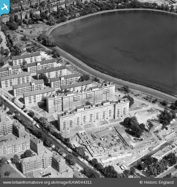
EAW044311 ENGLAND (1952). The Woodberry Down Estate between Seven Sisters Road and East Reservoir, Stamford Hill, 1952
    © Copyright OpenStreetMap contributors and licensed by the OpenStreetMap Foundation. 2025. Cartography is licensed as CC BY-SA.
  
Nearby Images (14)
Details
| Title | [EAW044311] The Woodberry Down Estate between Seven Sisters Road and East Reservoir, Stamford Hill, 1952 | 
| Reference | EAW044311 | 
| Date | 24-July-1952 | 
| Link | |
| Place name | STAMFORD HILL | 
| Parish | |
| District | |
| Country | ENGLAND | 
| Easting / Northing | 532616, 187686 | 
| Longitude / Latitude | -0.086178410214918, 51.57194958473 | 
| National Grid Reference | TQ326877 | 
Pins
Be the first to add a comment to this image!
 
             
  ![[EAW044311] The Woodberry Down Estate between Seven Sisters Road and East Reservoir, Stamford Hill, 1952](http://britainfromabove.org.uk/sites/all/libraries/aerofilms-images/public/100x100/EAW/044/EAW044311.jpg) 
  
                                          ![[EAW044327] The Woodberry Down Estate between Seven Sisters Road and East Reservoir, Stamford Hill, 1952](http://britainfromabove.org.uk/sites/all/libraries/aerofilms-images/public/100x100/EAW/044/EAW044327.jpg) 
 ![[EAW044316] The Woodberry Down Estate between New River and East Reservoir, Stamford Hill, 1952](http://britainfromabove.org.uk/sites/all/libraries/aerofilms-images/public/100x100/EAW/044/EAW044316.jpg) 
 ![[EAW044321] The Woodberry Down Estate between Seven Sisters Road and West Reservoir, Stamford Hill, 1952](http://britainfromabove.org.uk/sites/all/libraries/aerofilms-images/public/100x100/EAW/044/EAW044321.jpg) 
 ![[EAW044326] The Woodberry Down Estate between New River and East Reservoir, Stamford Hill, 1952](http://britainfromabove.org.uk/sites/all/libraries/aerofilms-images/public/100x100/EAW/044/EAW044326.jpg) 
 ![[EAW044325] The Woodberry Down Estate between New River and East Reservoir, Stamford Hill, 1952](http://britainfromabove.org.uk/sites/all/libraries/aerofilms-images/public/100x100/EAW/044/EAW044325.jpg) 
 ![[EAW044315] The Woodberry Down Estate between New River and East Reservoir, Stamford Hill, 1952](http://britainfromabove.org.uk/sites/all/libraries/aerofilms-images/public/100x100/EAW/044/EAW044315.jpg) 
 ![[EAW044322] The Woodberry Down Estate, Stamford Hill, 1952](http://britainfromabove.org.uk/sites/all/libraries/aerofilms-images/public/100x100/EAW/044/EAW044322.jpg) 
 ![[EAW044318] Seven Sisters Road, the Woodberry Down Estate and East Reservoir, Stamford Hill, 1952](http://britainfromabove.org.uk/sites/all/libraries/aerofilms-images/public/100x100/EAW/044/EAW044318.jpg) 
 ![[EAW044314] Woodberry Down Primary School on Woodberry Grove and part of the Woodberry Down Estate under construction, Stamford Hill, 1952](http://britainfromabove.org.uk/sites/all/libraries/aerofilms-images/public/100x100/EAW/044/EAW044314.jpg) 
 ![[EAW044312] Woodberry Down Primary School on Woodberry Grove, Stamford Hill, 1952](http://britainfromabove.org.uk/sites/all/libraries/aerofilms-images/public/100x100/EAW/044/EAW044312.jpg) 
 ![[EAW044320] The Woodberry Down Estate between New River and West Reservoir, Stamford Hill, 1952](http://britainfromabove.org.uk/sites/all/libraries/aerofilms-images/public/100x100/EAW/044/EAW044320.jpg) 
 ![[EAW044317] Seven Sisters Road, the Woodberry Down Estate and East Reservoir, Stamford Hill, 1952](http://britainfromabove.org.uk/sites/all/libraries/aerofilms-images/public/100x100/EAW/044/EAW044317.jpg) 
 ![[EAW044319] Lordship Road Bridge and the Woodberry Down Estate, Stamford Hill, 1952](http://britainfromabove.org.uk/sites/all/libraries/aerofilms-images/public/100x100/EAW/044/EAW044319.jpg)