
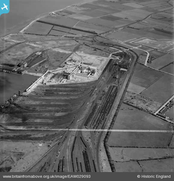
EAW029093 ENGLAND (1950). Immingham Dock, Immingham, 1950. This image was marked by Aerofilms Ltd for photo editing.
© Copyright OpenStreetMap contributors and licensed by the OpenStreetMap Foundation. 2026. Cartography is licensed as CC BY-SA.
Nearby Images (16)
EAW029093

EAW029102

EAW029094

EAW033210

EAW033218

EAW033217

EAW033216

EAW033211

EAW033219

EAW033209

EAW033208

EAW029096

EAW033205

EAW033215

EAW033212

EAW033214

Details
| Title | [EAW029093] Immingham Dock, Immingham, 1950. This image was marked by Aerofilms Ltd for photo editing. |
| Reference | EAW029093 |
| Date | 4-May-1950 |
| Link | |
| Place name | IMMINGHAM |
| Parish | IMMINGHAM |
| District | |
| Country | ENGLAND |
| Easting / Northing | 519631, 415507 |
| Longitude / Latitude | -0.19102775855631, 53.622179916761 |
| National Grid Reference | TA196155 |
Pins

redmist |
Thursday 15th of October 2020 11:13:11 PM | |
|
redmist |
Thursday 15th of October 2020 10:56:26 PM | |
|
redmist |
Saturday 23rd of February 2019 10:56:34 PM | |
|
redmist |
Saturday 23rd of February 2019 09:33:05 PM | |
|
redmist |
Saturday 23rd of February 2019 09:21:22 PM | |
|
redmist |
Thursday 26th of July 2018 10:32:47 PM | |

Grimsby Boy |
Tuesday 23rd of December 2014 10:29:50 PM | |
|
Grimsby Boy |
Tuesday 23rd of December 2014 10:27:20 PM | |
|
Grimsby Boy |
Tuesday 23rd of December 2014 10:26:32 PM | |
|
John Wass |
Saturday 12th of July 2014 11:14:09 AM | |
|
John Wass |
Friday 11th of July 2014 08:19:22 PM |