
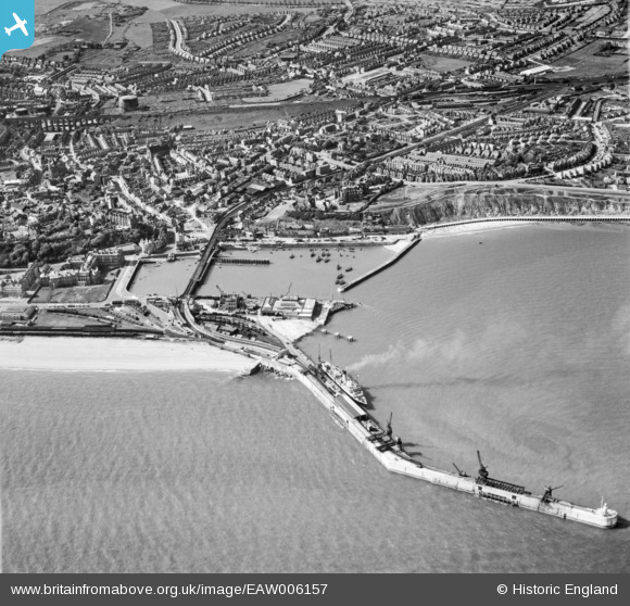
EAW006157 ENGLAND (1947). Folkestone Harbour, Folkestone, 1947
© Copyright OpenStreetMap contributors and licensed by the OpenStreetMap Foundation. 2026. Cartography is licensed as CC BY-SA.
Nearby Images (13)
EAW006157

EAW024826

EPW042865

EAW317182

EPW000149

EPW035410

EPW000372

EAW002378

EPW042866

EPW019065

EAW002853

EAW002849

EAW002850

Details
| Title | [EAW006157] Folkestone Harbour, Folkestone, 1947 |
| Reference | EAW006157 |
| Date | 27-May-1947 |
| Link | |
| Place name | FOLKESTONE |
| Parish | FOLKESTONE |
| District | |
| Country | ENGLAND |
| Easting / Northing | 623470, 135951 |
| Longitude / Latitude | 1.1907687414291, 51.078758730554 |
| National Grid Reference | TR235360 |
Pins

Sara |
Thursday 20th of March 2025 09:06:50 PM | |
|
Sara |
Thursday 20th of March 2025 09:05:38 PM | |
|
John Wass |
Monday 7th of May 2018 02:39:01 PM | |
|
cptpies |
Tuesday 10th of October 2017 02:46:06 PM | |

Billy Turner |
Thursday 28th of January 2016 10:01:27 PM | |
|
John Wass |
Tuesday 23rd of December 2014 08:56:34 PM | |
|
mannidaze |
Sunday 14th of September 2014 05:50:06 PM |

User Comment Contributions
Note the old Custom House on the South Quay in the apparent process of demolition. |
Martyn |
Monday 14th of July 2014 11:26:07 PM |