
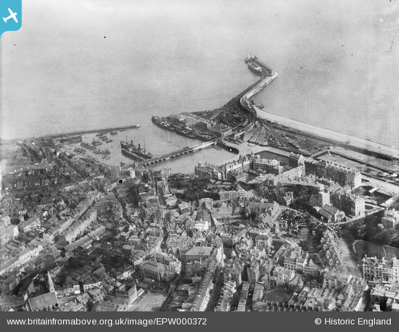
EPW000372 ENGLAND (1920). Inner Harbour and Outer Harbour, Folkestone, 1920
© Copyright OpenStreetMap contributors and licensed by the OpenStreetMap Foundation. 2026. Cartography is licensed as CC BY-SA.
Nearby Images (11)
EPW000372

EPW019065

EAW317182

EAW002853

EPW009196

EAW024826

EPW000149

EAW006157

EPW042865

EAW002372

EAW002852

Details
| Title | [EPW000372] Inner Harbour and Outer Harbour, Folkestone, 1920 |
| Reference | EPW000372 |
| Date | April-1920 |
| Link | |
| Place name | FOLKESTONE |
| Parish | FOLKESTONE |
| District | |
| Country | ENGLAND |
| Easting / Northing | 623277, 135912 |
| Longitude / Latitude | 1.1879935106677, 51.078483671432 |
| National Grid Reference | TR233359 |
Pins

zumiweb |
Friday 30th of January 2015 06:00:55 AM | |
|
Paolo |
Friday 20th of July 2012 04:22:38 PM | |
|
Paolo |
Friday 20th of July 2012 04:18:49 PM | |
|
Paolo |
Friday 20th of July 2012 04:16:58 PM | |
|
Paolo |
Friday 20th of July 2012 04:16:48 PM |
User Comment Contributions
The vessel at berth no 1 can only have been at this date the "Oranje Nassau" (1909-1952) probably inbound on the overnight service from Vlissingen |
Martyn |
Monday 14th of July 2014 11:03:43 PM |