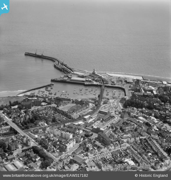
EAW317182 ENGLAND (1976). Town and harbour, Folkestone, 1976
© Copyright OpenStreetMap contributors and licensed by the OpenStreetMap Foundation. 2026. Cartography is licensed as CC BY-SA.
Nearby Images (13)
Details
| Title | [EAW317182] Town and harbour, Folkestone, 1976 |
| Reference | EAW317182 |
| Date | 10-June-1976 |
| Link | |
| Place name | FOLKESTONE |
| Parish | FOLKESTONE |
| District | |
| Country | ENGLAND |
| Easting / Northing | 623396, 135892 |
| Longitude / Latitude | 1.1896774374704, 51.078257771423 |
| National Grid Reference | TR234359 |
Pins

Sara |
Wednesday 24th of January 2024 07:08:02 PM | |

Sara |
Wednesday 24th of January 2024 07:07:39 PM | |

Sara |
Wednesday 24th of January 2024 07:05:59 PM |


![[EAW317182] Town and harbour, Folkestone, 1976](http://britainfromabove.org.uk/sites/all/libraries/aerofilms-images/public/100x100/EAW/317/EAW317182.jpg)
![[EAW024826] The harbour, Folkestone, 1949](http://britainfromabove.org.uk/sites/all/libraries/aerofilms-images/public/100x100/EAW/024/EAW024826.jpg)
![[EAW006157] Folkestone Harbour, Folkestone, 1947](http://britainfromabove.org.uk/sites/all/libraries/aerofilms-images/public/100x100/EAW/006/EAW006157.jpg)
![[EPW042865] The Harbour Pier, Inner and Outer Harbours and the town, Folkestone, 1933](http://britainfromabove.org.uk/sites/all/libraries/aerofilms-images/public/100x100/EPW/042/EPW042865.jpg)
![[EPW000372] Inner Harbour and Outer Harbour, Folkestone, 1920](http://britainfromabove.org.uk/sites/all/libraries/aerofilms-images/public/100x100/EPW/000/EPW000372.jpg)
![[EPW019065] The Inner Harbour, Royal Pavilion Hotel and environs, Folkestone, 1927](http://britainfromabove.org.uk/sites/all/libraries/aerofilms-images/public/100x100/EPW/019/EPW019065.jpg)
![[EPW000149] Outer Harbour and Fish Market, Folkestone, 1920](http://britainfromabove.org.uk/sites/all/libraries/aerofilms-images/public/100x100/EPW/000/EPW000149.jpg)
![[EAW002853] The Folkestone Harbour Railway Station, the Royal Pavilion Hotel and the town, Folkestone, from the south-east, 1946](http://britainfromabove.org.uk/sites/all/libraries/aerofilms-images/public/100x100/EAW/002/EAW002853.jpg)
![[EPW035410] The Harbour Lighthouse, the Outer Harbour and East Cliff, Folkestone, 1931](http://britainfromabove.org.uk/sites/all/libraries/aerofilms-images/public/100x100/EPW/035/EPW035410.jpg)
![[EAW002849] An unidentified ship moored at Folkestone Harbour Pier, Folkestone, 1946](http://britainfromabove.org.uk/sites/all/libraries/aerofilms-images/public/100x100/EAW/002/EAW002849.jpg)
![[EAW002850] Folkestone Harbour Pier, the Outer Harbour and the town, Folkestone, 1946](http://britainfromabove.org.uk/sites/all/libraries/aerofilms-images/public/100x100/EAW/002/EAW002850.jpg)
![[EAW002378] Folkestone Harbour Pier and the town, Folkestone, 1946](http://britainfromabove.org.uk/sites/all/libraries/aerofilms-images/public/100x100/EAW/002/EAW002378.jpg)
![[EAW002848] Folkestone Harbour Pier, Folkestone, 1946](http://britainfromabove.org.uk/sites/all/libraries/aerofilms-images/public/100x100/EAW/002/EAW002848.jpg)