Skip to main content
Prydain oddi Fry
Cymraeg
|
English
Mewngofnod
|
Cofrestru
Toggle navigation
Hafan
Gwaddol
Ynghylch
Map
Orielau
Grwpiau
Cymorth
Chwilio
Pob Gwlad (96344)
Lloegr (82521)
Yr Alban (6398)
Cymru (4321)
Gweddill y Byd (3104)
Gwlad Belg (7)
Ffrainc (27)
yr Almaen (2)
Guernsey (116)
Iran (8)
Irac (6)
Iwerddon (1466)
Ynys Manaw (75)
Jersey (122)
yr Iseldiroedd (20)
Northern Ireland (1163)
Sbaen (9)
y Swisdir (26)
Gweithgaredd Diweddaraf
Saved Images
Pagination
Current page
1
Tudalen
2
Next page
next
Last page
last
[EAW001215] Wolverhampton Road and the industrial and residential area at Round's Green, Oldbury, 1946
[EAW001216] Wolverhampton Road and the industrial and residential area at Round's Green, Oldbury, 1946
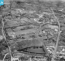
[EAW001225] Wolverhampton Road, housing at Borough Crescent and the surrounding area, Oldbury, 1946
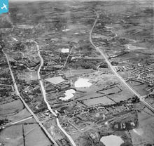
[EAW001221] Titford Pool, housing at Borough Crescent and the Blue Rock Quarries, Oldbury, 1946
[EAW001222] Titford Pool, housing at Borough Crescent and the Blue Rock Quarries, Oldbury, 1946
[EAW001221] Titford Pool, housing at Borough Crescent and the Blue Rock Quarries, Oldbury, 1946
[EAW001223] Titford Pool, housing at Borough Crescent and the Blue Rock Quarries, Oldbury, 1946
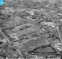
[EAW001224] Titford Pool, housing at Borough Crescent and the surrounding area, Oldbury, 1946
Pagination
Current page
1
Tudalen
2
Next page
next
Last page
last
This user has had no activity in the last year.