
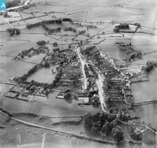
SPW034408 SCOTLAND (1930). Wigtown, general view, showing The Square and Southfield Park. An oblique aerial photograph taken facing west.

© Hawlfraint cyfranwyr OpenStreetMap a thrwyddedwyd gan yr OpenStreetMap Foundation. 2026. Trwyddedir y gartograffeg fel CC BY-SA.
Delweddau cyfagos (4)
SPW034408

SPW034410

SPW034411

SPW034409

Manylion
| Pennawd | [SPW034408] Wigtown, general view, showing The Square and Southfield Park. An oblique aerial photograph taken facing west. |
| Cyfeirnod | SPW034408 |
| Dyddiad | 1930 |
| Dolen | NRHE Collection item 1257139 |
| Enw lle | |
| Plwyf | WIGTOWN |
| Ardal | WIGTOWN |
| Gwlad | SCOTLAND |
| Dwyreiniad / Gogleddiad | 243371, 555308 |
| Hydred / Lledred | -4.4410051713012, 54.867895735413 |
| Cyfeirnod Grid Cenedlaethol | NX434553 |
Pinnau

Mounthooly |
Sunday 1st of July 2012 01:20:57 PM |

Cyfraniadau Grŵp
Off in the distance to the left corner is Bladnoch Distillery. Not the best of photo's I know. |
Mounthooly |
Sunday 1st of July 2012 12:20:40 PM |