
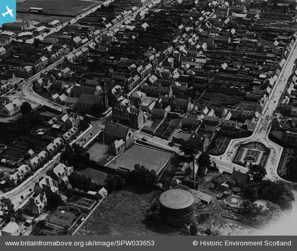
SPW033653 SCOTLAND (1930). Keith, general view, showing Church Road and Mid Street. An oblique aerial photograph taken facing south. This image has been produced from a print.
© Hawlfraint cyfranwyr OpenStreetMap a thrwyddedwyd gan yr OpenStreetMap Foundation. 2026. Trwyddedir y gartograffeg fel CC BY-SA.
Delweddau cyfagos (8)
SPW033652

SPW033653

SPW033651

SPW033655

SAR023875

SAR023876

SAR023877

SAR025574

Manylion
| Pennawd | [SPW033653] Keith, general view, showing Church Road and Mid Street. An oblique aerial photograph taken facing south. This image has been produced from a print. |
| Cyfeirnod | SPW033653 |
| Dyddiad | 1930 |
| Dolen | NRHE Collection item 1315486 |
| Enw lle | |
| Plwyf | KEITH |
| Ardal | MORAY |
| Gwlad | SCOTLAND |
| Dwyreiniad / Gogleddiad | 343281, 850704 |
| Hydred / Lledred | -2.9476354609038, 57.543130872803 |
| Cyfeirnod Grid Cenedlaethol | NJ433507 |
Pinnau
Byddwch y cyntaf i ychwanegu sylw at y ddelwedd hon!
Cyfraniadau Grŵp
James Naughtie went to school here - Keith Grammar School from nearby village Rothiemay. Chivas Regal stored here. |

rettendon6 |
Saturday 27th of July 2013 10:44:07 AM |