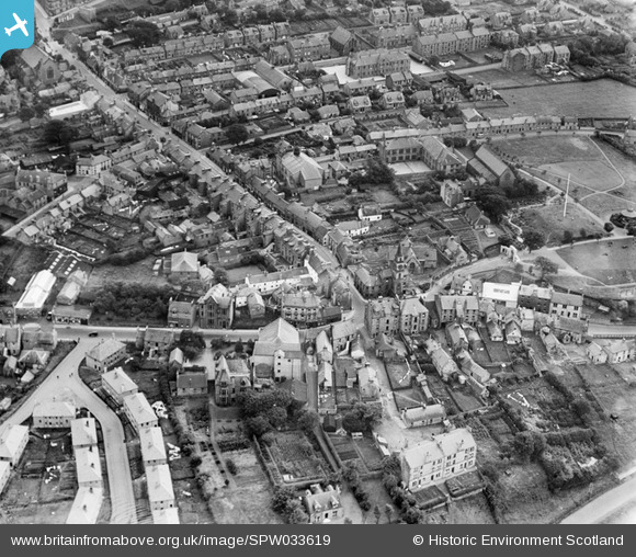
SPW033619 SCOTLAND (1930). Kirkintilloch, general view, showing Old Church, Cowgate and High Street. An oblique aerial photograph taken facing south.
    © Hawlfraint cyfranwyr OpenStreetMap a thrwyddedwyd gan yr OpenStreetMap Foundation. 2025. Trwyddedir y gartograffeg fel CC BY-SA.
  
Manylion
| Pennawd | [SPW033619] Kirkintilloch, general view, showing Old Church, Cowgate and High Street. An oblique aerial photograph taken facing south. | 
| Cyfeirnod | SPW033619 | 
| Dyddiad | 1930 | 
| Dolen | NRHE Collection item 1259375 | 
| Enw lle | |
| Plwyf | KIRKINTILLOCH (STRATHKELVIN) | 
| Ardal | STRATHKELVIN | 
| Gwlad | SCOTLAND | 
| Dwyreiniad / Gogleddiad | 265260, 674100 | 
| Hydred / Lledred | -4.157526858381, 55.941071326236 | 
| Cyfeirnod Grid Cenedlaethol | NS653741 | 
Pinnau
|  Kirkintilloch Town Hall |   Bill Craik | Thursday 25th of June 2015 06:03:12 PM | 
|  The Orchard Burial Ground. was exhumed by Strathkelvin District Council to allow a new road to be built.  The remains are now in Old Ailse Cemeterey Kirkintilloch.  Some remains were identified in the old register as having had small pox. |   Bill Craik | Thursday 25th of June 2015 06:00:50 PM | 
|  McLays |   almagill | Sunday 11th of January 2015 06:38:43 PM | 
|  Black Bull Cinema |   almagill | Sunday 11th of January 2015 06:37:15 PM | 
|  St Mary's (CoS) |   almagill | Sunday 11th of January 2015 06:36:19 PM | 
|  St Ninian's RC |   almagill | Sunday 11th of January 2015 06:35:35 PM | 
|  The Peel |   almagill | Sunday 11th of January 2015 06:34:41 PM | 
|  The Auld Kirk (St Mary's) |   almagill | Sunday 11th of January 2015 06:34:13 PM | 
|  Barony Chambers |   almagill | Sunday 11th of January 2015 06:33:02 PM | 
 
             
  ![[SPW033619] Kirkintilloch, general view, showing Old Church, Cowgate and High Street.  An oblique aerial photograph taken facing south.](http://britainfromabove.org.uk/sites/all/libraries/aerofilms-images/public/100x100/SPW/033/SPW033619.jpg) 
  
                                          ![[SPW033617] Kirkintilloch, general view, showing Cowgate and Kerr Street.  An oblique aerial photograph taken facing south.](http://britainfromabove.org.uk/sites/all/libraries/aerofilms-images/public/100x100/SPW/033/SPW033617.jpg) 
 ![[SPW033615] Kirkintilloch, general view, showing St Mary's Parish Church, Cowgate and Kerr Street.  An oblique aerial photograph taken facing south-west.](http://britainfromabove.org.uk/sites/all/libraries/aerofilms-images/public/100x100/SPW/033/SPW033615.jpg) 
 ![[SPW033616] Kirkintilloch, general view, showing St Mary's Parish Church, Cowgate and Forth and Clyde Canal.  An oblique aerial photograph taken facing north-west.](http://britainfromabove.org.uk/sites/all/libraries/aerofilms-images/public/100x100/SPW/033/SPW033616.jpg)