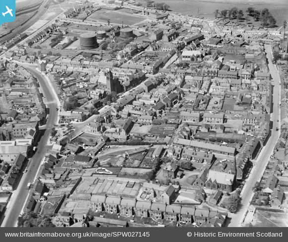
SPW027145 SCOTLAND (1929). Bathgate, general view, showing St David's Church and South Bridge Street. An oblique aerial photograph taken facing north.
    © Hawlfraint cyfranwyr OpenStreetMap a thrwyddedwyd gan yr OpenStreetMap Foundation. 2025. Trwyddedir y gartograffeg fel CC BY-SA.
  
Delweddau cyfagos (7)
Manylion
| Pennawd | [SPW027145] Bathgate, general view, showing St David's Church and South Bridge Street. An oblique aerial photograph taken facing north. | 
| Cyfeirnod | SPW027145 | 
| Dyddiad | 1929 | 
| Dolen | NRHE Collection item 1256720 | 
| Enw lle | |
| Plwyf | BATHGATE | 
| Ardal | WEST LOTHIAN | 
| Gwlad | SCOTLAND | 
| Dwyreiniad / Gogleddiad | 297480, 668808 | 
| Hydred / Lledred | -3.6398702659386, 55.901489453194 | 
| Cyfeirnod Grid Cenedlaethol | NS975688 | 
Pinnau
|  Rosemount Cottages. My Great Grandparents Stewart lived here, their son William died in the Quintinshill (Gretna) Rail Disaster of 1915 aged 22 rob.mcginley@btinternet.com |   Rob McGinley | Wednesday 18th of December 2019 10:14:41 AM | 
 
             
  ![[SPW027145] Bathgate, general view, showing St David's Church and South Bridge Street.  An oblique aerial photograph taken facing north.](http://britainfromabove.org.uk/sites/all/libraries/aerofilms-images/public/100x100/SPW/027/SPW027145.jpg) 
  
                                          ![[SPW027148] Bathgate, general view, showing St David's Church and King Street.  An oblique aerial photograph taken facing north.](http://britainfromabove.org.uk/sites/all/libraries/aerofilms-images/public/100x100/SPW/027/SPW027148.jpg) 
 ![[SPW027151] Bathgate, general view, showing St David's Church and Church of the Immaculate Conception.  An oblique aerial photograph taken facing east.](http://britainfromabove.org.uk/sites/all/libraries/aerofilms-images/public/100x100/SPW/027/SPW027151.jpg) 
 ![[SPW027150] Bathgate, general view, showing Upper Station and Whitburn Road.  An oblique aerial photograph taken facing north.](http://britainfromabove.org.uk/sites/all/libraries/aerofilms-images/public/100x100/SPW/027/SPW027150.jpg) 
 ![[SPW027147] Bathgate, general view, showing St David's Church and North Bridge Street.  An oblique aerial photograph taken facing north-east.](http://britainfromabove.org.uk/sites/all/libraries/aerofilms-images/public/100x100/SPW/027/SPW027147.jpg) 
 ![[SPW027153] West Lothian Hosiery Works, Gardners Lane, Bathgate.  An oblique aerial photograph taken facing north-east.](http://britainfromabove.org.uk/sites/all/libraries/aerofilms-images/public/100x100/SPW/027/SPW027153.jpg) 
 ![[SPW027149] Bathgate, general view, showing St John's Church and Mid Street.  An oblique aerial photograph taken facing north-west.](http://britainfromabove.org.uk/sites/all/libraries/aerofilms-images/public/100x100/SPW/027/SPW027149.jpg)