
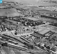
SAW017828 SCOTLAND (1948). Paisley, general view, showing Arbuckle Smith and Co., Mackean Street and Abbotsinch Airfield. An oblique aerial photograph taken facing north. This image has been produced from a crop marked negative.

© Hawlfraint cyfranwyr OpenStreetMap a thrwyddedwyd gan yr OpenStreetMap Foundation. 2026. Trwyddedir y gartograffeg fel CC BY-SA.
Delweddau cyfagos (6)
SAW017828

SAW017829

SAW017830

SAW017831

SAW017832

SAW017833

Manylion
| Pennawd | [SAW017828] Paisley, general view, showing Arbuckle Smith and Co., Mackean Street and Abbotsinch Airfield. An oblique aerial photograph taken facing north. This image has been produced from a crop marked negative. |
| Cyfeirnod | SAW017828 |
| Dyddiad | 1948 |
| Dolen | NRHE Collection item 1269092 |
| Enw lle | |
| Plwyf | PAISLEY (RENFREW) |
| Ardal | RENFREW |
| Gwlad | SCOTLAND |
| Dwyreiniad / Gogleddiad | 247425, 664850 |
| Hydred / Lledred | -4.4376203765973, 55.852698536095 |
| Cyfeirnod Grid Cenedlaethol | NS474649 |
Pinnau

Ian Smeeton |
Wednesday 15th of October 2025 01:35:47 PM | |
|
MB |
Sunday 24th of January 2021 03:40:31 PM | |
|
MB |
Sunday 24th of January 2021 03:39:03 PM | |

Matt Aldred edob.mattaldred.com |
Saturday 5th of December 2020 02:45:58 PM | |
|
Matt Aldred edob.mattaldred.com |
Saturday 5th of December 2020 02:45:41 PM | |
|
Matt Aldred edob.mattaldred.com |
Saturday 5th of December 2020 02:44:53 PM | |
|
JohnF |
Friday 28th of August 2020 03:16:56 PM | |
|
jimmy |
Monday 21st of May 2018 12:09:00 PM | |
|
Jaytee25 |
Monday 7th of May 2018 06:50:57 PM | |
|
Jaytee25 |
Monday 7th of May 2018 06:46:12 PM | |
|
jimmy |
Friday 25th of August 2017 07:12:10 PM | |
|
bossjock |
Saturday 21st of June 2014 11:53:35 PM | |
|
MB |
Friday 25th of April 2014 03:43:20 PM | |
|
MB |
Friday 25th of April 2014 03:42:22 PM | |
|
jimmy |
Wednesday 23rd of April 2014 07:47:22 PM | |
|
jimmy |
Wednesday 23rd of April 2014 07:45:52 PM | |
|
Triggy |
Friday 24th of January 2014 09:00:20 PM | |
|
cptpies |
Monday 13th of January 2014 11:25:44 AM | |
|
cptpies |
Monday 13th of January 2014 11:25:25 AM | |
|
bossjock |
Sunday 25th of November 2012 10:13:46 AM | |
|
bossjock |
Sunday 25th of November 2012 09:48:36 AM | |
|
bossjock |
Sunday 25th of November 2012 09:47:13 AM | |
|
bossjock |
Sunday 25th of November 2012 09:45:37 AM | |
|
bossjock |
Sunday 25th of November 2012 09:45:10 AM | |
|
jimmy |
Monday 27th of August 2012 04:23:08 PM | |
|
jimmy |
Monday 27th of August 2012 04:19:34 PM | |
|
jimmy |
Monday 27th of August 2012 04:16:29 PM | |
|
Eagle Eye |
Saturday 14th of July 2012 05:32:37 PM | |
|
Eagle Eye |
Saturday 14th of July 2012 05:31:40 PM | |
|
Eagle Eye |
Saturday 14th of July 2012 05:29:51 PM | |
|
bossjock |
Saturday 30th of June 2012 01:00:50 AM | |
|
bossjock |
Saturday 30th of June 2012 12:59:36 AM | |
|
bossjock |
Saturday 30th of June 2012 12:59:07 AM | |
|
bossjock |
Saturday 30th of June 2012 12:57:21 AM | |
|
bossjock |
Saturday 30th of June 2012 12:54:46 AM | |
|
bossjock |
Saturday 30th of June 2012 12:53:50 AM | |
|
bossjock |
Saturday 30th of June 2012 12:48:58 AM | |
|
bossjock |
Saturday 30th of June 2012 12:48:19 AM | |
|
bossjock |
Saturday 30th of June 2012 12:47:38 AM | |
|
bossjock |
Saturday 30th of June 2012 12:46:43 AM |
Cyfraniadau Grŵp
Abbotsinch pillbox. |
cptpies |
Thursday 19th of December 2013 02:14:12 PM |
A superb image showing to the top left the Hangers and Nissan huts of the then Royal Air Force 602 Squadron (City of Glasgow) Auxiliary Air Force and later,from 1943, exclusively the Royal Navy Fleet Air Arm Base HMS Sanderling. The Navy left in 1963 and the airfield became Glasgow Airport replacing the old airport at Renfrew. Greenock Road (running NW -SE)is now cut in half with both the main runway for the airport and the M8 Motorway. The M8 runs East to West in a line approximately running between the Nissan Huts to the right and the Prefab Housing (Gockston, and the runway in a SW - NE direction just to the North of the large Hangers (which still exist and house 'Loganair') The large park with the Bandstand is St James Park, locally know as the Racecourse as it was at one time in the early 1900's used for that purpose. Interesting also to see the Fairground in the park which suggestes this photo would have been taken during the first fortnight in August - the Paisley Fair- when the town all but ground to a halt for the annual fortnights holidays. |
bossjock |
Monday 25th of June 2012 10:31:24 PM |