
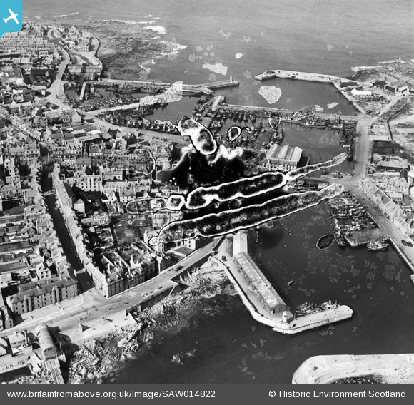
SAW014822 SCOTLAND (1948). Peterhead, general view, showing Peterhead Harbour and Jamaica Street. An oblique aerial photograph taken facing north. This image has been produced from a damaged negative.
© Hawlfraint cyfranwyr OpenStreetMap a thrwyddedwyd gan yr OpenStreetMap Foundation. 2026. Trwyddedir y gartograffeg fel CC BY-SA.
Delweddau cyfagos (5)
SAW014822

SAW014825

SAW019632

SAW019634

SAW014819

Manylion
| Pennawd | [SAW014822] Peterhead, general view, showing Peterhead Harbour and Jamaica Street. An oblique aerial photograph taken facing north. This image has been produced from a damaged negative. |
| Cyfeirnod | SAW014822 |
| Dyddiad | 1948 |
| Dolen | NRHE Collection item 1268924 |
| Enw lle | |
| Plwyf | PETERHEAD |
| Ardal | BANFF AND BUCHAN |
| Gwlad | SCOTLAND |
| Dwyreiniad / Gogleddiad | 413606, 845936 |
| Hydred / Lledred | -1.7729267238306, 57.503648681245 |
| Cyfeirnod Grid Cenedlaethol | NK136459 |
Pinnau

Matt Aldred edob.mattaldred.com |
Thursday 4th of March 2021 03:17:50 PM | |

redmist |
Saturday 30th of January 2021 10:40:24 AM | |
|
redmist |
Saturday 30th of January 2021 10:14:30 AM | |
|
redmist |
Saturday 30th of January 2021 10:13:56 AM | |
|
jrussill |
Tuesday 14th of January 2014 12:27:56 PM |
Cyfraniadau Grŵp

WW2 Pillbox? |
jrussill |
Tuesday 14th of January 2014 12:28:28 PM |