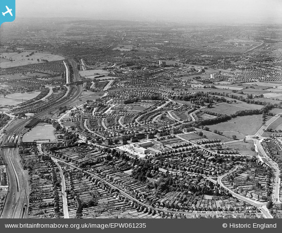
EPW061235 ENGLAND (1939). Overlooking the new Town Hall towards Barn Hill, Wembley, from the south-east, 1939
© Hawlfraint cyfranwyr OpenStreetMap a thrwyddedwyd gan yr OpenStreetMap Foundation. 2026. Trwyddedir y gartograffeg fel CC BY-SA.
Manylion
| Pennawd | [EPW061235] Overlooking the new Town Hall towards Barn Hill, Wembley, from the south-east, 1939 |
| Cyfeirnod | EPW061235 |
| Dyddiad | 26-May-1939 |
| Dolen | |
| Enw lle | WEMBLEY |
| Plwyf | |
| Ardal | |
| Gwlad | ENGLAND |
| Dwyreiniad / Gogleddiad | 519823, 186600 |
| Hydred / Lledred | -0.27107313955343, 51.565053009835 |
| Cyfeirnod Grid Cenedlaethol | TQ198866 |
Pinnau

Drdub |
Thursday 10th of June 2021 07:08:52 PM | |

Drdub |
Thursday 10th of June 2021 06:54:56 PM | |

fern |
Tuesday 6th of November 2018 05:23:43 PM | |

The Laird |
Thursday 3rd of November 2016 04:59:44 PM | |

The Laird |
Wednesday 29th of April 2015 01:05:44 PM | |

The Laird |
Wednesday 29th of April 2015 10:36:13 AM | |

The Laird |
Wednesday 29th of April 2015 10:26:02 AM | |

The Laird |
Wednesday 29th of April 2015 10:25:05 AM | |

The Laird |
Wednesday 29th of April 2015 10:23:24 AM | |

The Laird |
Wednesday 29th of April 2015 10:22:36 AM | |

The Laird |
Wednesday 29th of April 2015 10:16:20 AM | |

The Laird |
Wednesday 29th of April 2015 10:15:34 AM | |

The Laird |
Wednesday 29th of April 2015 10:06:22 AM | |

The Laird |
Wednesday 29th of April 2015 09:59:14 AM | |

The Laird |
Wednesday 29th of April 2015 09:57:46 AM | |

The Laird |
Wednesday 29th of April 2015 09:55:33 AM | |

The Laird |
Wednesday 29th of April 2015 09:51:17 AM | |

The Laird |
Wednesday 29th of April 2015 09:47:14 AM | |

The Laird |
Wednesday 29th of April 2015 09:44:08 AM | |

The Laird |
Wednesday 29th of April 2015 09:33:45 AM | |

The Laird |
Wednesday 29th of April 2015 09:23:07 AM | |

Sweet Pete |
Sunday 1st of February 2015 02:55:40 PM | |

Sweet Pete |
Sunday 1st of February 2015 02:55:11 PM |
Cyfraniadau Grŵp
Aha! I've always wondered and now I know... On google map images of this area there is a 'Barn Hill Lawn Tennis Clubhouse' marked but it's in the middle of a small wooded area. Here you can clearly see three tennis courts laid out to the middle right of the picture. Can't find any info on the tennis club though. |

Hillbilly |
Tuesday 28th of April 2015 10:48:26 PM |


![[EPW061235] Overlooking the new Town Hall towards Barn Hill, Wembley, from the south-east, 1939](http://britainfromabove.org.uk/sites/all/libraries/aerofilms-images/public/100x100/EPW/061/EPW061235.jpg)
![[EPW035049] The Mount and traffic queueing on Forty Lane, Wembley Park, 1931. This image has been produced from a damaged negative.](http://britainfromabove.org.uk/sites/all/libraries/aerofilms-images/public/100x100/EPW/035/EPW035049.jpg)