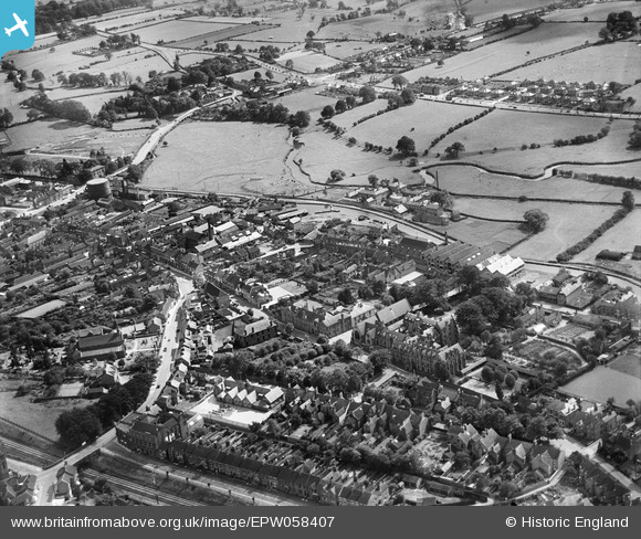
EPW058407 ENGLAND (1938). The town centre, Stone, 1938
© Hawlfraint cyfranwyr OpenStreetMap a thrwyddedwyd gan yr OpenStreetMap Foundation. 2026. Trwyddedir y gartograffeg fel CC BY-SA.
Delweddau cyfagos (28)
Manylion
| Pennawd | [EPW058407] The town centre, Stone, 1938 |
| Cyfeirnod | EPW058407 |
| Dyddiad | 28-July-1938 |
| Dolen | |
| Enw lle | STONE |
| Plwyf | STONE |
| Ardal | |
| Gwlad | ENGLAND |
| Dwyreiniad / Gogleddiad | 390024, 333944 |
| Hydred / Lledred | -2.1483311434644, 52.9025215096 |
| Cyfeirnod Grid Cenedlaethol | SJ900339 |
Pinnau

bescotbeast |
Sunday 5th of January 2025 12:09:17 PM | |

bescotbeast |
Sunday 5th of January 2025 12:08:55 PM | |

bix_the_dog |
Sunday 19th of February 2023 02:59:54 PM | |

bix_the_dog |
Sunday 19th of February 2023 02:51:24 PM | |

totoro |
Friday 12th of July 2013 10:46:14 PM | |

totoro |
Friday 12th of July 2013 10:11:47 PM | |

totoro |
Friday 12th of July 2013 10:10:25 PM | |

totoro |
Friday 12th of July 2013 10:09:30 PM | |

totoro |
Friday 12th of July 2013 10:09:07 PM | |

totoro |
Friday 12th of July 2013 10:08:18 PM | |

totoro |
Friday 12th of July 2013 10:00:10 PM | |

totoro |
Friday 12th of July 2013 09:46:34 PM | |

totoro |
Friday 12th of July 2013 09:44:03 PM | |

totoro |
Friday 12th of July 2013 09:40:19 PM | |

totoro |
Friday 12th of July 2013 09:39:20 PM | |

totoro |
Friday 12th of July 2013 09:38:47 PM | |

totoro |
Friday 12th of July 2013 09:38:08 PM | |

totoro |
Friday 12th of July 2013 09:35:38 PM | |

totoro |
Friday 12th of July 2013 09:34:43 PM | |

totoro |
Friday 12th of July 2013 09:34:08 PM | |

totoro |
Friday 12th of July 2013 09:19:35 PM | |

totoro |
Friday 12th of July 2013 09:19:15 PM | |

totoro |
Friday 12th of July 2013 09:17:52 PM | |

totoro |
Friday 12th of July 2013 09:16:57 PM | |

totoro |
Friday 12th of July 2013 09:15:55 PM |


![[EPW058407] The town centre, Stone, 1938](http://britainfromabove.org.uk/sites/all/libraries/aerofilms-images/public/100x100/EPW/058/EPW058407.jpg)
![[EPW026984] Newcastle Street, The Square and environs, Stone, 1929](http://britainfromabove.org.uk/sites/all/libraries/aerofilms-images/public/100x100/EPW/026/EPW026984.jpg)
![[EPW026985] The town and surrounding countryside, Stone, 1929](http://britainfromabove.org.uk/sites/all/libraries/aerofilms-images/public/100x100/EPW/026/EPW026985.jpg)
![[EPW042630] The Joule's Brewery Ale Stores, Stone, 1933](http://britainfromabove.org.uk/sites/all/libraries/aerofilms-images/public/100x100/EPW/042/EPW042630.jpg)
![[EPW042631] The Joule's Brewery Ale Stores, Stone, 1933](http://britainfromabove.org.uk/sites/all/libraries/aerofilms-images/public/100x100/EPW/042/EPW042631.jpg)
![[EPW042632] The Joule's Brewery Ale Stores, Stone, 1933](http://britainfromabove.org.uk/sites/all/libraries/aerofilms-images/public/100x100/EPW/042/EPW042632.jpg)
![[EPW053351] St Dominic's Convent and the town centre, Stone, 1937](http://britainfromabove.org.uk/sites/all/libraries/aerofilms-images/public/100x100/EPW/053/EPW053351.jpg)
![[EPW020073] Margaret Street and environs, Stone, 1927](http://britainfromabove.org.uk/sites/all/libraries/aerofilms-images/public/100x100/EPW/020/EPW020073.jpg)
![[EPW042627] Joule's Brewery, Stone, 1933](http://britainfromabove.org.uk/sites/all/libraries/aerofilms-images/public/100x100/EPW/042/EPW042627.jpg)
![[EPW042628] Joule's Brewery, Stone, 1933](http://britainfromabove.org.uk/sites/all/libraries/aerofilms-images/public/100x100/EPW/042/EPW042628.jpg)
![[EPW042629] Joule's Brewery, Stone, 1933. This image has been produced from a damaged negative.](http://britainfromabove.org.uk/sites/all/libraries/aerofilms-images/public/100x100/EPW/042/EPW042629.jpg)
![[EPW026981] The High Street and town centre, Stone, 1929](http://britainfromabove.org.uk/sites/all/libraries/aerofilms-images/public/100x100/EPW/026/EPW026981.jpg)
![[EPW026979] St Dominic's Convent and RC Church and environs, Stone, 1929](http://britainfromabove.org.uk/sites/all/libraries/aerofilms-images/public/100x100/EPW/026/EPW026979.jpg)
![[EPW058404] The High Street and environs, Stone, 1938](http://britainfromabove.org.uk/sites/all/libraries/aerofilms-images/public/100x100/EPW/058/EPW058404.jpg)
![[EPW058371] The town Gas Works, Stone, 1938](http://britainfromabove.org.uk/sites/all/libraries/aerofilms-images/public/100x100/EPW/058/EPW058371.jpg)
![[EPW047679] The town, Stone, 1935](http://britainfromabove.org.uk/sites/all/libraries/aerofilms-images/public/100x100/EPW/047/EPW047679.jpg)
![[EPW058370] The town Gas Works, Stone, 1938. This image has been produced from a damaged negative.](http://britainfromabove.org.uk/sites/all/libraries/aerofilms-images/public/100x100/EPW/058/EPW058370.jpg)
![[EPW020072] Newcastle Street and surroundings, Stone, 1927](http://britainfromabove.org.uk/sites/all/libraries/aerofilms-images/public/100x100/EPW/020/EPW020072.jpg)
![[EPW058368] The town Gas Works, Stone, 1938](http://britainfromabove.org.uk/sites/all/libraries/aerofilms-images/public/100x100/EPW/058/EPW058368.jpg)
![[EPW020071] The town centre, Stone, 1927](http://britainfromabove.org.uk/sites/all/libraries/aerofilms-images/public/100x100/EPW/020/EPW020071.jpg)
![[EPW058366] The town Gas Works and the High Street, Stone, 1938](http://britainfromabove.org.uk/sites/all/libraries/aerofilms-images/public/100x100/EPW/058/EPW058366.jpg)
![[EPW026986] The town and surrounding countryside, Stone, 1929](http://britainfromabove.org.uk/sites/all/libraries/aerofilms-images/public/100x100/EPW/026/EPW026986.jpg)
![[EPW058367] The town Gas Works, Stone, 1938](http://britainfromabove.org.uk/sites/all/libraries/aerofilms-images/public/100x100/EPW/058/EPW058367.jpg)
![[EPW058372] The town Gas Works and Star Lock Bridge, Stone, 1938](http://britainfromabove.org.uk/sites/all/libraries/aerofilms-images/public/100x100/EPW/058/EPW058372.jpg)
![[EPW058369] The town Gas Works and Star Lock Bridge, Stone, 1938](http://britainfromabove.org.uk/sites/all/libraries/aerofilms-images/public/100x100/EPW/058/EPW058369.jpg)
![[EPW042624] The Stone Gas and Electricity Company Works, Stone, 1933. This image has been produced from a damaged negative.](http://britainfromabove.org.uk/sites/all/libraries/aerofilms-images/public/100x100/EPW/042/EPW042624.jpg)
![[EPW042626] The Stone Gas and Electricity Company Works, Stone, 1933](http://britainfromabove.org.uk/sites/all/libraries/aerofilms-images/public/100x100/EPW/042/EPW042626.jpg)
![[EPW042625] The Stone Gas and Electricity Company Works, Stone, 1933. This image was marked by Aerofilms Ltd for photo editing.](http://britainfromabove.org.uk/sites/all/libraries/aerofilms-images/public/100x100/EPW/042/EPW042625.jpg)
