
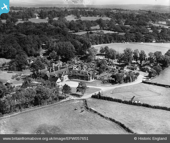
EPW057651 ENGLAND (1938). The Homestall (Stoke Brunswick School) and the surrounding countryside, Forest Row, from the north-west, 1938. This image has been produced from a damaged negative.
© Hawlfraint cyfranwyr OpenStreetMap a thrwyddedwyd gan yr OpenStreetMap Foundation. 2026. Trwyddedir y gartograffeg fel CC BY-SA.
Delweddau cyfagos (18)
EPW057651
 and the surrounding countryside, Forest Row, from the north-west, 1938. This image has been produced from a damaged negative.")
EPW058215
, Forest Row, 1938")
EPW058217
, Forest Row, from the west, 1938")
EPW058219
, Forest Row, from the west, 1938")
EPW058216
, Forest Row, 1938")
EPW033847

EPW058218
, Forest Row, 1938")
EPW057652
, Forest Row, 1938. This image has been produced from a damaged negative.")
EPW033853

EPW058221
 and surrounding countryside, Forest Row, from the south-west, 1938")
EPW033850

EPW033848

EPW057653
, Forest Row, 1938. This image has been produced from a damaged negative.")
EPW057654
, Forest Row, 1938. This image has been produced from a damaged negative.")
EPW033852

EPW033851

EPW058220
, Forest Row, 1938")
EPW033849

Manylion
| Pennawd | [EPW057651] The Homestall (Stoke Brunswick School) and the surrounding countryside, Forest Row, from the north-west, 1938. This image has been produced from a damaged negative. |
| Cyfeirnod | EPW057651 |
| Dyddiad | 21-June-1938 |
| Dolen | |
| Enw lle | FOREST ROW |
| Plwyf | FOREST ROW |
| Ardal | |
| Gwlad | ENGLAND |
| Dwyreiniad / Gogleddiad | 542096, 137488 |
| Hydred / Lledred | 0.03049716361792, 51.11850832734 |
| Cyfeirnod Grid Cenedlaethol | TQ421375 |
Pinnau
Byddwch y cyntaf i ychwanegu sylw at y ddelwedd hon!
Cyfraniadau Grŵp
For 1930 images see eg image EPW033849 which is confusingly under the name Stoke Brunswick, unlike these 1938 images which are under Forest Row! This 1938 series was taken after the Cheshire mansion was moved here whereas the 1930 series are before the Cheshire mansion arrived on this site. The two series should be viewed side by side. |

totoro |
Tuesday 30th of July 2013 09:22:39 PM |