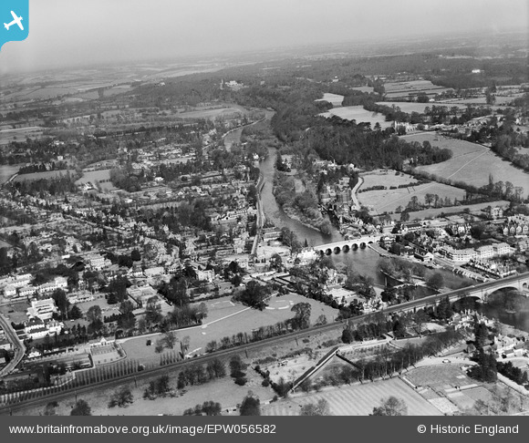
EPW056582 ENGLAND (1938). Maidenhead Bridge and the town, Maidenhead, from the south, 1938
    © Hawlfraint cyfranwyr OpenStreetMap a thrwyddedwyd gan yr OpenStreetMap Foundation. 2025. Trwyddedir y gartograffeg fel CC BY-SA.
  
Delweddau cyfagos (11)
Manylion
| Pennawd | [EPW056582] Maidenhead Bridge and the town, Maidenhead, from the south, 1938 | 
| Cyfeirnod | EPW056582 | 
| Dyddiad | March-1938 | 
| Dolen | |
| Enw lle | MAIDENHEAD | 
| Plwyf | |
| Ardal | |
| Gwlad | ENGLAND | 
| Dwyreiniad / Gogleddiad | 489972, 181103 | 
| Hydred / Lledred | -0.70306063193096, 51.521188689858 | 
| Cyfeirnod Grid Cenedlaethol | SU900811 | 
Pinnau
|  Ray Mill Island |   misterjohn | Monday 2nd of January 2023 01:44:46 PM | 
|  Sir Percy Flanagan pub. Now VW garage |   designking | Saturday 15th of October 2022 09:32:39 PM | 
|  The Showboat roadhouse (built 1933; now Exclusive House) |   Emily Cole | Wednesday 28th of March 2018 12:11:39 PM | 
 
             
  ![[EPW056582] Maidenhead Bridge and the town, Maidenhead, from the south, 1938](http://britainfromabove.org.uk/sites/all/libraries/aerofilms-images/public/100x100/EPW/056/EPW056582.jpg) 
  
                                          ![[EAW021598] Maidenhead Bridge and the River Thameas, Maidenhead, from the south-west, 1949](http://britainfromabove.org.uk/sites/all/libraries/aerofilms-images/public/100x100/EAW/021/EAW021598.jpg) 
 ![[EPW022619] Maidenhead Bridge and surroundings, Maidenhead, 1928](http://britainfromabove.org.uk/sites/all/libraries/aerofilms-images/public/100x100/EPW/022/EPW022619.jpg) 
 ![[EPW056581] Maidenhead Bridge, the Fish Weir and the Railway Viaduct, Maidenhead, 1938](http://britainfromabove.org.uk/sites/all/libraries/aerofilms-images/public/100x100/EPW/056/EPW056581.jpg) 
 ![[EPW005695] View of the town and Maidenhead Bridge, Maidenhead, from the south-east, 1921](http://britainfromabove.org.uk/sites/all/libraries/aerofilms-images/public/100x100/EPW/005/EPW005695.jpg) 
 ![[EPW022710] Maidenhead Bridge and Maidenhead Viaduct, Maidenhead, 1928](http://britainfromabove.org.uk/sites/all/libraries/aerofilms-images/public/100x100/EPW/022/EPW022710.jpg) 
 ![[EAW026482] Maidenhead Viaduct and the town, Maidenhead, from the south, 1949](http://britainfromabove.org.uk/sites/all/libraries/aerofilms-images/public/100x100/EAW/026/EAW026482.jpg) 
 ![[EAW003814] Flooding around the Great Western Railway Line and Bridge Road, Maidenhead, 1947](http://britainfromabove.org.uk/sites/all/libraries/aerofilms-images/public/100x100/EAW/003/EAW003814.jpg) 
 ![[EAW013948] Maidenhead Bridge, Ray Park Avenue and environs, Maidenhead, from the south, 1948. This image has been produced from a print.](http://britainfromabove.org.uk/sites/all/libraries/aerofilms-images/public/100x100/EAW/013/EAW013948.jpg) 
 ![[EPW022721] Maidenhead Bridge, Maidenhead, 1928](http://britainfromabove.org.uk/sites/all/libraries/aerofilms-images/public/100x100/EPW/022/EPW022721.jpg) 
 ![[EAW003666] Flooding around Maidenhead Bridge and Bridge Road, Maidenhead, from the east, 1947](http://britainfromabove.org.uk/sites/all/libraries/aerofilms-images/public/100x100/EAW/003/EAW003666.jpg)