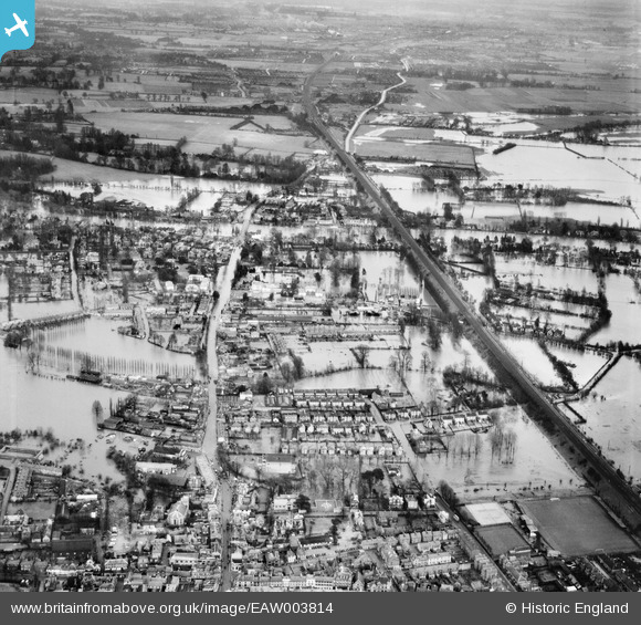
EAW003814 ENGLAND (1947). Flooding around the Great Western Railway Line and Bridge Road, Maidenhead, 1947
    © Hawlfraint cyfranwyr OpenStreetMap a thrwyddedwyd gan yr OpenStreetMap Foundation. 2025. Trwyddedir y gartograffeg fel CC BY-SA.
  
Delweddau cyfagos (5)
Manylion
| Pennawd | [EAW003814] Flooding around the Great Western Railway Line and Bridge Road, Maidenhead, 1947 | 
| Cyfeirnod | EAW003814 | 
| Dyddiad | 19-March-1947 | 
| Dolen | |
| Enw lle | MAIDENHEAD | 
| Plwyf | |
| Ardal | |
| Gwlad | ENGLAND | 
| Dwyreiniad / Gogleddiad | 489733, 181205 | 
| Hydred / Lledred | -0.70647886924447, 51.522143718744 | 
| Cyfeirnod Grid Cenedlaethol | SU897812 | 
Pinnau
|  Maidenhead United F.C |   spikey1810 | Friday 11th of October 2024 02:47:44 PM | 
|  The showboat roadhouse and pool |   robinb | Wednesday 24th of December 2014 12:58:11 PM | 
 
             
  ![[EAW003814] Flooding around the Great Western Railway Line and Bridge Road, Maidenhead, 1947](http://britainfromabove.org.uk/sites/all/libraries/aerofilms-images/public/100x100/EAW/003/EAW003814.jpg) 
  
                                          ![[EPW000901] View of Maidenhead and Maidenhead Bridge, Maidenhead, from the north-west, 1920](http://britainfromabove.org.uk/sites/all/libraries/aerofilms-images/public/100x100/EPW/000/EPW000901.jpg) 
 ![[EAW003813] Flooding around the Great Western Railway Line, Maidenhead, 1947](http://britainfromabove.org.uk/sites/all/libraries/aerofilms-images/public/100x100/EAW/003/EAW003813.jpg) 
 ![[EAW003815] Flooding around the Great Western Railway Line and Bridge Road, Maidenhead, from the north-west, 1947](http://britainfromabove.org.uk/sites/all/libraries/aerofilms-images/public/100x100/EAW/003/EAW003815.jpg) 
 ![[EPW056582] Maidenhead Bridge and the town, Maidenhead, from the south, 1938](http://britainfromabove.org.uk/sites/all/libraries/aerofilms-images/public/100x100/EPW/056/EPW056582.jpg)