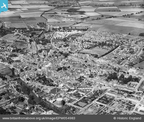
EPW054983 ENGLAND (1937). The town, Stamford, from the south-east, 1937
© Hawlfraint cyfranwyr OpenStreetMap a thrwyddedwyd gan yr OpenStreetMap Foundation. 2026. Trwyddedir y gartograffeg fel CC BY-SA.
Delweddau cyfagos (12)
Manylion
| Pennawd | [EPW054983] The town, Stamford, from the south-east, 1937 |
| Cyfeirnod | EPW054983 |
| Dyddiad | 17-August-1937 |
| Dolen | |
| Enw lle | STAMFORD |
| Plwyf | STAMFORD |
| Ardal | |
| Gwlad | ENGLAND |
| Dwyreiniad / Gogleddiad | 503291, 307087 |
| Hydred / Lledred | -0.47295635950412, 52.651316063668 |
| Cyfeirnod Grid Cenedlaethol | TF033071 |


![[EPW054983] The town, Stamford, from the south-east, 1937](http://britainfromabove.org.uk/sites/all/libraries/aerofilms-images/public/100x100/EPW/054/EPW054983.jpg)
![[EPW054984] The town, Stamford, from the south-east, 1937](http://britainfromabove.org.uk/sites/all/libraries/aerofilms-images/public/100x100/EPW/054/EPW054984.jpg)
![[EAW008131] Brewery and malt house buildings between Barnack Road and Water Street, the railway terminus and gas works, Stamford, 1947. This image was marked by Aerofilms Ltd for photo editing.](http://britainfromabove.org.uk/sites/all/libraries/aerofilms-images/public/100x100/EAW/008/EAW008131.jpg)
![[EAW008132] Albert Bridge, the River Welland and environs, Stamford, 1947. This image was marked by Aerofilms Ltd for photo editing.](http://britainfromabove.org.uk/sites/all/libraries/aerofilms-images/public/100x100/EAW/008/EAW008132.jpg)
![[EAW008127] Brewery and malt house buildings between Barnack Road and Water Street and environs, Stamford, 1947](http://britainfromabove.org.uk/sites/all/libraries/aerofilms-images/public/100x100/EAW/008/EAW008127.jpg)
![[EAW008126] Albert Bridge, Water Street, the railway terminus and envrions, Stamford, 1947](http://britainfromabove.org.uk/sites/all/libraries/aerofilms-images/public/100x100/EAW/008/EAW008126.jpg)
![[EAW008130] Brewery and malt house buildings between Barnack Road and Water Street and the railway terminus, Stamford, 1947](http://britainfromabove.org.uk/sites/all/libraries/aerofilms-images/public/100x100/EAW/008/EAW008130.jpg)
![[EAW008128] Brewery and malt house buildings between Barnack Road and Water Street, Stamford, 1947. This image was marked by Aerofilms Ltd for photo editing.](http://britainfromabove.org.uk/sites/all/libraries/aerofilms-images/public/100x100/EAW/008/EAW008128.jpg)
![[EAW008129] Brewery and malt house buildings between Barnack Road and Water Street, Stamford, 1947. This image was marked by Aerofilms Ltd for photo editing.](http://britainfromabove.org.uk/sites/all/libraries/aerofilms-images/public/100x100/EAW/008/EAW008129.jpg)
![[EAW008125] Brewery and malt house buildings between Barnack Road and Water Street, Stamford, 1947](http://britainfromabove.org.uk/sites/all/libraries/aerofilms-images/public/100x100/EAW/008/EAW008125.jpg)
![[EAW013391] Broad Street and the town centre, Stamford, 1948](http://britainfromabove.org.uk/sites/all/libraries/aerofilms-images/public/100x100/EAW/013/EAW013391.jpg)
![[EAW033044] Broad Street, Ironmonger Street and the town, Stamford, 1950](http://britainfromabove.org.uk/sites/all/libraries/aerofilms-images/public/100x100/EAW/033/EAW033044.jpg)
