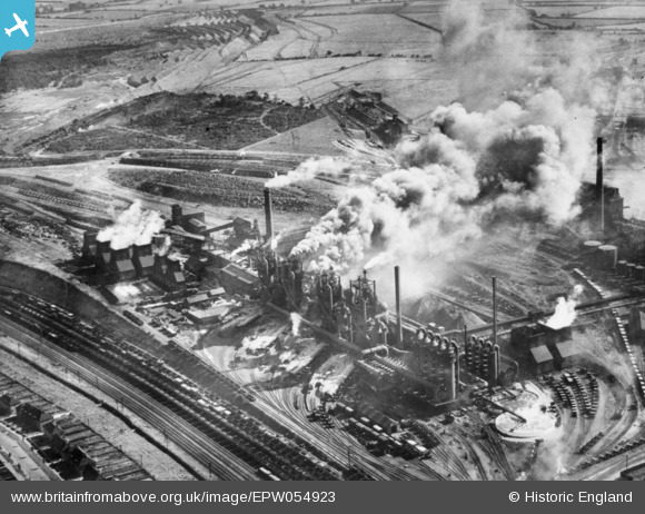
EPW054923 ENGLAND (1937). Part of the Stewarts and Lloyds Iron and Steel Works, Corby, 1937. This image has been produced from a copy-negative.
© Hawlfraint cyfranwyr OpenStreetMap a thrwyddedwyd gan yr OpenStreetMap Foundation. 2026. Trwyddedir y gartograffeg fel CC BY-SA.
Delweddau cyfagos (22)
Manylion
| Pennawd | [EPW054923] Part of the Stewarts and Lloyds Iron and Steel Works, Corby, 1937. This image has been produced from a copy-negative. |
| Cyfeirnod | EPW054923 |
| Dyddiad | 16-August-1937 |
| Dolen | |
| Enw lle | CORBY |
| Plwyf | |
| Ardal | |
| Gwlad | ENGLAND |
| Dwyreiniad / Gogleddiad | 489751, 289615 |
| Hydred / Lledred | -0.67780098596863, 52.496679735764 |
| Cyfeirnod Grid Cenedlaethol | SP898896 |
Pinnau
Byddwch y cyntaf i ychwanegu sylw at y ddelwedd hon!


![[EPW054923] Part of the Stewarts and Lloyds Iron and Steel Works, Corby, 1937. This image has been produced from a copy-negative.](http://britainfromabove.org.uk/sites/all/libraries/aerofilms-images/public/100x100/EPW/054/EPW054923.jpg)
![[EPW049767] The Iron and Steel Works, Corby, 1936](http://britainfromabove.org.uk/sites/all/libraries/aerofilms-images/public/100x100/EPW/049/EPW049767.jpg)
![[EAW034118] Stewarts and Lloyds Ltd Iron & Steel Works, Corby, 1950. This image was marked by Aerofilms Ltd for photo editing.](http://britainfromabove.org.uk/sites/all/libraries/aerofilms-images/public/100x100/EAW/034/EAW034118.jpg)
![[EPW054912] Part of the Stewarts and Lloyds Iron and Steel Works, Corby, 1937. This image has been produced from a copy-negative affected by flare.](http://britainfromabove.org.uk/sites/all/libraries/aerofilms-images/public/100x100/EPW/054/EPW054912.jpg)
![[EAW034121] Stewarts and Lloyds Ltd Iron & Steel Works, Corby, 1950. This image was marked by Aerofilms Ltd for photo editing.](http://britainfromabove.org.uk/sites/all/libraries/aerofilms-images/public/100x100/EAW/034/EAW034121.jpg)
![[EPW049765] The Iron and Steel Works, Corby, 1936](http://britainfromabove.org.uk/sites/all/libraries/aerofilms-images/public/100x100/EPW/049/EPW049765.jpg)
![[EAW045453] Part of the Stewarts & Lloyds Ltd Steelworks and the surrounding area, Corby, from the south-east, 1952](http://britainfromabove.org.uk/sites/all/libraries/aerofilms-images/public/100x100/EAW/045/EAW045453.jpg)
![[EAW034114] Stewarts and Lloyds Ltd Iron & Steel Works, Corby, 1950. This image was marked by Aerofilms Ltd for photo editing.](http://britainfromabove.org.uk/sites/all/libraries/aerofilms-images/public/100x100/EAW/034/EAW034114.jpg)
![[EAW045438] The residential area surrounding Whitworth Avenue alongside the Stewarts & Lloyds Ltd Steelworks, Corby, from the south-east, 1952](http://britainfromabove.org.uk/sites/all/libraries/aerofilms-images/public/100x100/EAW/045/EAW045438.jpg)
![[EAW034117] Stewarts and Lloyds Ltd Iron & Steel Works, Corby, 1950. This image was marked by Aerofilms Ltd for photo editing.](http://britainfromabove.org.uk/sites/all/libraries/aerofilms-images/public/100x100/EAW/034/EAW034117.jpg)
![[EAW034116] Stewarts and Lloyds Ltd Iron & Steel Works, Corby, 1950. This image was marked by Aerofilms Ltd for photo editing.](http://britainfromabove.org.uk/sites/all/libraries/aerofilms-images/public/100x100/EAW/034/EAW034116.jpg)
![[EPW054913] Part of the Stewarts and Lloyds Iron and Steel Works, Corby, 1937. This image has been produced from a copy-negative.](http://britainfromabove.org.uk/sites/all/libraries/aerofilms-images/public/100x100/EPW/054/EPW054913.jpg)
![[EAW034123] Stewarts and Lloyds Ltd Iron & Steel Works, Corby, 1950. This image was marked by Aerofilms Ltd for photo editing.](http://britainfromabove.org.uk/sites/all/libraries/aerofilms-images/public/100x100/EAW/034/EAW034123.jpg)
![[EPW049770] The Iron and Steel Works, Corby, 1936](http://britainfromabove.org.uk/sites/all/libraries/aerofilms-images/public/100x100/EPW/049/EPW049770.jpg)
![[EAW034119] Stewarts and Lloyds Ltd Iron & Steel Works, Corby, 1950. This image was marked by Aerofilms Ltd for photo editing.](http://britainfromabove.org.uk/sites/all/libraries/aerofilms-images/public/100x100/EAW/034/EAW034119.jpg)
![[EPW049774] The By-Product Plant at the Iron and Steel Works, Corby, 1936](http://britainfromabove.org.uk/sites/all/libraries/aerofilms-images/public/100x100/EPW/049/EPW049774.jpg)
![[EAW034120] Stewarts and Lloyds Ltd Iron & Steel Works, Corby, 1950. This image was marked by Aerofilms Ltd for photo editing.](http://britainfromabove.org.uk/sites/all/libraries/aerofilms-images/public/100x100/EAW/034/EAW034120.jpg)
![[EPW049775] The By-Product Plant at the Iron and Steel Works, Corby, 1936](http://britainfromabove.org.uk/sites/all/libraries/aerofilms-images/public/100x100/EPW/049/EPW049775.jpg)
![[EAW034113] Stewarts and Lloyds Ltd Iron & Steel Works, Corby, 1950. This image was marked by Aerofilms Ltd for photo editing.](http://britainfromabove.org.uk/sites/all/libraries/aerofilms-images/public/100x100/EAW/034/EAW034113.jpg)
![[EPW049772] The Iron and Steel Works, Corby, 1936](http://britainfromabove.org.uk/sites/all/libraries/aerofilms-images/public/100x100/EPW/049/EPW049772.jpg)
![[EAW034115] Stewarts and Lloyds Ltd Iron & Steel Works, Corby, 1950. This image was marked by Aerofilms Ltd for photo editing.](http://britainfromabove.org.uk/sites/all/libraries/aerofilms-images/public/100x100/EAW/034/EAW034115.jpg)
![[EPW049771] The By-Product Plant at the Iron and Steel Works, Corby, 1936](http://britainfromabove.org.uk/sites/all/libraries/aerofilms-images/public/100x100/EPW/049/EPW049771.jpg)