
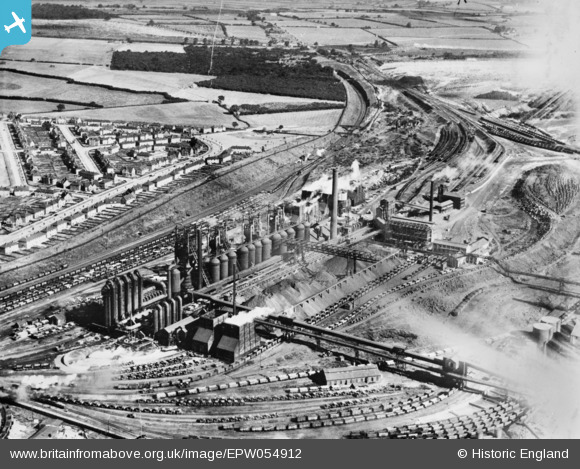
EPW054912 ENGLAND (1937). Part of the Stewarts and Lloyds Iron and Steel Works, Corby, 1937. This image has been produced from a copy-negative affected by flare.
© Hawlfraint cyfranwyr OpenStreetMap a thrwyddedwyd gan yr OpenStreetMap Foundation. 2026. Trwyddedir y gartograffeg fel CC BY-SA.
Delweddau cyfagos (20)
EPW054912

EPW049767

EPW049765

EPW054923

EAW045453

EAW034118

EAW045438

EAW034121

EAW034117

EAW034114

EPW049772

EAW034116

EPW054913

EAW034120

EAW034123

EAW034119

EAW034113

EPW049774

EPW049771

EAW034115

Manylion
| Pennawd | [EPW054912] Part of the Stewarts and Lloyds Iron and Steel Works, Corby, 1937. This image has been produced from a copy-negative affected by flare. |
| Cyfeirnod | EPW054912 |
| Dyddiad | 16-August-1937 |
| Dolen | |
| Enw lle | CORBY |
| Plwyf | |
| Ardal | |
| Gwlad | ENGLAND |
| Dwyreiniad / Gogleddiad | 489660, 289595 |
| Hydred / Lledred | -0.67914658560151, 52.496514933589 |
| Cyfeirnod Grid Cenedlaethol | SP897896 |
Pinnau
Byddwch y cyntaf i ychwanegu sylw at y ddelwedd hon!