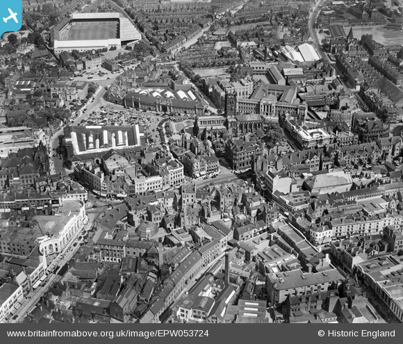
EPW053724 ENGLAND (1937). The city centre picturing St Peter's Collegiate Church, the Market Hall and the Molineux Grounds, Wolverhampton, 1937
© Hawlfraint cyfranwyr OpenStreetMap a thrwyddedwyd gan yr OpenStreetMap Foundation. 2026. Trwyddedir y gartograffeg fel CC BY-SA.
Delweddau cyfagos (15)
Manylion
| Pennawd | [EPW053724] The city centre picturing St Peter's Collegiate Church, the Market Hall and the Molineux Grounds, Wolverhampton, 1937 |
| Cyfeirnod | EPW053724 |
| Dyddiad | June-1937 |
| Dolen | |
| Enw lle | WOLVERHAMPTON |
| Plwyf | |
| Ardal | |
| Gwlad | ENGLAND |
| Dwyreiniad / Gogleddiad | 391409, 298711 |
| Hydred / Lledred | -2.126815019404, 52.585780204189 |
| Cyfeirnod Grid Cenedlaethol | SO914987 |
Pinnau

Claire |
Sunday 16th of March 2025 07:37:56 PM | |

Claire |
Sunday 16th of March 2025 07:37:29 PM | |

Claire |
Tuesday 5th of May 2020 12:34:22 PM | |

garygareth |
Sunday 10th of November 2013 10:42:36 AM | |

garygareth |
Sunday 10th of November 2013 10:40:05 AM | |

garygareth |
Sunday 10th of November 2013 10:39:26 AM | |

garygareth |
Sunday 10th of November 2013 10:38:29 AM | |

garygareth |
Sunday 10th of November 2013 10:38:00 AM | |

garygareth |
Sunday 10th of November 2013 10:37:26 AM | |

garygareth |
Sunday 10th of November 2013 10:36:42 AM | |

garygareth |
Sunday 10th of November 2013 10:35:52 AM |


![[EPW053724] The city centre picturing St Peter's Collegiate Church, the Market Hall and the Molineux Grounds, Wolverhampton, 1937](http://britainfromabove.org.uk/sites/all/libraries/aerofilms-images/public/100x100/EPW/053/EPW053724.jpg)
![[EPW011835] Queen Square and environs, Wolverhampton, 1924. This image has been produced from a print affected by flare.](http://britainfromabove.org.uk/sites/all/libraries/aerofilms-images/public/100x100/EPW/011/EPW011835.jpg)
![[EPW022595] St Peter's Collegiate Church, Wolverhampton, 1928](http://britainfromabove.org.uk/sites/all/libraries/aerofilms-images/public/100x100/EPW/022/EPW022595.jpg)
![[EPW011832] The city centre, Wolverhampton, 1924. This image has been produced from a copy-negative.](http://britainfromabove.org.uk/sites/all/libraries/aerofilms-images/public/100x100/EPW/011/EPW011832.jpg)
![[EPW053728] St Peter's Collegiate Church, the Market Hall and the city centre, Wolverhampton, 1937](http://britainfromabove.org.uk/sites/all/libraries/aerofilms-images/public/100x100/EPW/053/EPW053728.jpg)
![[EPW057476] The town centre, Wolverhampton, 1938](http://britainfromabove.org.uk/sites/all/libraries/aerofilms-images/public/100x100/EPW/057/EPW057476.jpg)
![[EPW053729] St Peter's Collegiate Church, the Market Place and the Market Hall, Wolverhampton, 1937](http://britainfromabove.org.uk/sites/all/libraries/aerofilms-images/public/100x100/EPW/053/EPW053729.jpg)
![[EAW017630] Dudley Street, Market Street and environs, Wolverhampton, 1948. This image has been produced from a print.](http://britainfromabove.org.uk/sites/all/libraries/aerofilms-images/public/100x100/EAW/017/EAW017630.jpg)
![[EPW053730] The city centre picturing Victoria Street, the Market Hall and the Civic Hall, Wolverhampton, 1937](http://britainfromabove.org.uk/sites/all/libraries/aerofilms-images/public/100x100/EPW/053/EPW053730.jpg)
![[EPR000569] Victoria Street and the town centre, Wolverhampton, 1935. This image was marked by Aero Pictorial Ltd for photo editing.](http://britainfromabove.org.uk/sites/all/libraries/aerofilms-images/public/100x100/EPR/000/EPR000569.jpg)
![[EPW011774] Princes Square and environs, Wolverhampton, 1924. This image has been produced from a print.](http://britainfromabove.org.uk/sites/all/libraries/aerofilms-images/public/100x100/EPW/011/EPW011774.jpg)
![[EPW022897] St Peter's Collegiate Church and the Market Place, Wolverhampton, from the north, 1928](http://britainfromabove.org.uk/sites/all/libraries/aerofilms-images/public/100x100/EPW/022/EPW022897.jpg)
![[EPR000556] Market Hall and the town centre, Wolverhampton, 1935](http://britainfromabove.org.uk/sites/all/libraries/aerofilms-images/public/100x100/EPR/000/EPR000556.jpg)
![[EPW057479] Victoria Street and the town centre, Wolverhampton, 1938](http://britainfromabove.org.uk/sites/all/libraries/aerofilms-images/public/100x100/EPW/057/EPW057479.jpg)
![[EPW057473] Skinner Street and environs, Wolverhampton, 1938](http://britainfromabove.org.uk/sites/all/libraries/aerofilms-images/public/100x100/EPW/057/EPW057473.jpg)