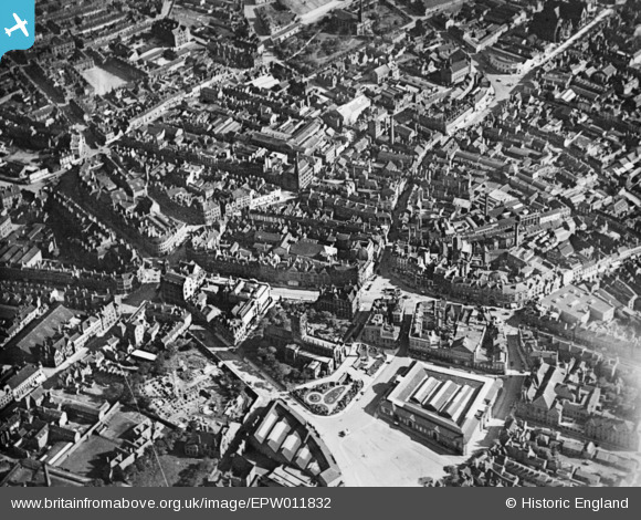
EPW011832 ENGLAND (1924). The city centre, Wolverhampton, 1924. This image has been produced from a copy-negative.
© Hawlfraint cyfranwyr OpenStreetMap a thrwyddedwyd gan yr OpenStreetMap Foundation. 2026. Trwyddedir y gartograffeg fel CC BY-SA.
Delweddau cyfagos (16)
Manylion
| Pennawd | [EPW011832] The city centre, Wolverhampton, 1924. This image has been produced from a copy-negative. |
| Cyfeirnod | EPW011832 |
| Dyddiad | September-1924 |
| Dolen | |
| Enw lle | WOLVERHAMPTON |
| Plwyf | |
| Ardal | |
| Gwlad | ENGLAND |
| Dwyreiniad / Gogleddiad | 391501, 298697 |
| Hydred / Lledred | -2.1254566165539, 52.585655778973 |
| Cyfeirnod Grid Cenedlaethol | SO915987 |


![[EPW011832] The city centre, Wolverhampton, 1924. This image has been produced from a copy-negative.](http://britainfromabove.org.uk/sites/all/libraries/aerofilms-images/public/100x100/EPW/011/EPW011832.jpg)
![[EAW017630] Dudley Street, Market Street and environs, Wolverhampton, 1948. This image has been produced from a print.](http://britainfromabove.org.uk/sites/all/libraries/aerofilms-images/public/100x100/EAW/017/EAW017630.jpg)
![[EPW057476] The town centre, Wolverhampton, 1938](http://britainfromabove.org.uk/sites/all/libraries/aerofilms-images/public/100x100/EPW/057/EPW057476.jpg)
![[EPW011774] Princes Square and environs, Wolverhampton, 1924. This image has been produced from a print.](http://britainfromabove.org.uk/sites/all/libraries/aerofilms-images/public/100x100/EPW/011/EPW011774.jpg)
![[EPW011835] Queen Square and environs, Wolverhampton, 1924. This image has been produced from a print affected by flare.](http://britainfromabove.org.uk/sites/all/libraries/aerofilms-images/public/100x100/EPW/011/EPW011835.jpg)
![[EPW053724] The city centre picturing St Peter's Collegiate Church, the Market Hall and the Molineux Grounds, Wolverhampton, 1937](http://britainfromabove.org.uk/sites/all/libraries/aerofilms-images/public/100x100/EPW/053/EPW053724.jpg)
![[EPW022595] St Peter's Collegiate Church, Wolverhampton, 1928](http://britainfromabove.org.uk/sites/all/libraries/aerofilms-images/public/100x100/EPW/022/EPW022595.jpg)
![[EPW053728] St Peter's Collegiate Church, the Market Hall and the city centre, Wolverhampton, 1937](http://britainfromabove.org.uk/sites/all/libraries/aerofilms-images/public/100x100/EPW/053/EPW053728.jpg)
![[EPW053729] St Peter's Collegiate Church, the Market Place and the Market Hall, Wolverhampton, 1937](http://britainfromabove.org.uk/sites/all/libraries/aerofilms-images/public/100x100/EPW/053/EPW053729.jpg)
![[EPW011780] Victoria Square and environs, Wolverhampton, 1924. This image has been produced from a print.](http://britainfromabove.org.uk/sites/all/libraries/aerofilms-images/public/100x100/EPW/011/EPW011780.jpg)
![[EPR000569] Victoria Street and the town centre, Wolverhampton, 1935. This image was marked by Aero Pictorial Ltd for photo editing.](http://britainfromabove.org.uk/sites/all/libraries/aerofilms-images/public/100x100/EPR/000/EPR000569.jpg)
![[EPW053730] The city centre picturing Victoria Street, the Market Hall and the Civic Hall, Wolverhampton, 1937](http://britainfromabove.org.uk/sites/all/libraries/aerofilms-images/public/100x100/EPW/053/EPW053730.jpg)
![[EPW022897] St Peter's Collegiate Church and the Market Place, Wolverhampton, from the north, 1928](http://britainfromabove.org.uk/sites/all/libraries/aerofilms-images/public/100x100/EPW/022/EPW022897.jpg)
![[EPW057474] Piper's Row and the town centre, Wolverhampton, 1938](http://britainfromabove.org.uk/sites/all/libraries/aerofilms-images/public/100x100/EPW/057/EPW057474.jpg)
![[EPR000556] Market Hall and the town centre, Wolverhampton, 1935](http://britainfromabove.org.uk/sites/all/libraries/aerofilms-images/public/100x100/EPR/000/EPR000556.jpg)
![[EPW057479] Victoria Street and the town centre, Wolverhampton, 1938](http://britainfromabove.org.uk/sites/all/libraries/aerofilms-images/public/100x100/EPW/057/EPW057479.jpg)
