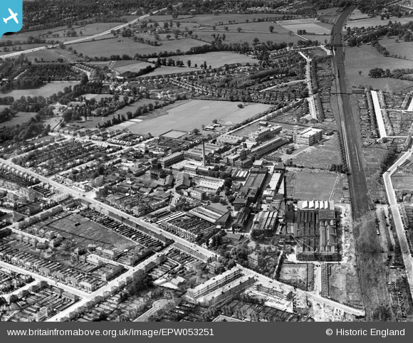
EPW053251 ENGLAND (1937). The Kodak Works and environs, Harrow, 1937
© Hawlfraint cyfranwyr OpenStreetMap a thrwyddedwyd gan yr OpenStreetMap Foundation. 2026. Trwyddedir y gartograffeg fel CC BY-SA.
Delweddau cyfagos (24)
Manylion
| Pennawd | [EPW053251] The Kodak Works and environs, Harrow, 1937 |
| Cyfeirnod | EPW053251 |
| Dyddiad | 27-May-1937 |
| Dolen | |
| Enw lle | HARROW |
| Plwyf | |
| Ardal | |
| Gwlad | ENGLAND |
| Dwyreiniad / Gogleddiad | 514621, 189732 |
| Hydred / Lledred | -0.34507587963967, 51.594286962983 |
| Cyfeirnod Grid Cenedlaethol | TQ146897 |
Pinnau

Sweet Pete |
Saturday 13th of February 2016 03:03:29 PM | |

Sweet Pete |
Saturday 13th of February 2016 03:02:38 PM | |

Mark Amies |
Wednesday 23rd of July 2014 03:54:59 PM | |

The Laird |
Thursday 26th of June 2014 12:18:32 PM |


![[EPW053251] The Kodak Works and environs, Harrow, 1937](http://britainfromabove.org.uk/sites/all/libraries/aerofilms-images/public/100x100/EPW/053/EPW053251.jpg)
![[EAW035177] A Redex banner on tow over the Kodak Works, Harrow, from the north-east, 1951](http://britainfromabove.org.uk/sites/all/libraries/aerofilms-images/public/100x100/EAW/035/EAW035177.jpg)
![[EPW053255] The Kodak Works and environs, Harrow, 1937](http://britainfromabove.org.uk/sites/all/libraries/aerofilms-images/public/100x100/EPW/053/EPW053255.jpg)
![[EPW053248] The Kodak Works and environs, Harrow, 1937](http://britainfromabove.org.uk/sites/all/libraries/aerofilms-images/public/100x100/EPW/053/EPW053248.jpg)
![[EPW053245] The Kodak Works and environs, Harrow, 1937](http://britainfromabove.org.uk/sites/all/libraries/aerofilms-images/public/100x100/EPW/053/EPW053245.jpg)
![[EPW053246] The Kodak Works and environs, Harrow, 1937](http://britainfromabove.org.uk/sites/all/libraries/aerofilms-images/public/100x100/EPW/053/EPW053246.jpg)
![[EPW053257] The Kodak Works, Harrow, 1937. This image has been produced from a damaged negative.](http://britainfromabove.org.uk/sites/all/libraries/aerofilms-images/public/100x100/EPW/053/EPW053257.jpg)
![[EPW053247] The Kodak Works and environs, Harrow, 1937](http://britainfromabove.org.uk/sites/all/libraries/aerofilms-images/public/100x100/EPW/053/EPW053247.jpg)
![[EPW053254] The Kodak Works and environs, Harrow, 1937](http://britainfromabove.org.uk/sites/all/libraries/aerofilms-images/public/100x100/EPW/053/EPW053254.jpg)
![[EPW053249] The Kodak Works and environs, Harrow, 1937](http://britainfromabove.org.uk/sites/all/libraries/aerofilms-images/public/100x100/EPW/053/EPW053249.jpg)
![[EPW037281] The Kodak Works, Harrow, 1932](http://britainfromabove.org.uk/sites/all/libraries/aerofilms-images/public/100x100/EPW/037/EPW037281.jpg)
![[EPW037265] The Kodak Works and environs, Harrow, 1932](http://britainfromabove.org.uk/sites/all/libraries/aerofilms-images/public/100x100/EPW/037/EPW037265.jpg)
![[EPW062563] The Kodak Works and environs, Harrow, 1939. This image has been affected by flare.](http://britainfromabove.org.uk/sites/all/libraries/aerofilms-images/public/100x100/EPW/062/EPW062563.jpg)
![[EPW062558] The Kodak Works and environs, Harrow, 1939](http://britainfromabove.org.uk/sites/all/libraries/aerofilms-images/public/100x100/EPW/062/EPW062558.jpg)
![[EPW062560] The Kodak Works and environs, Harrow, 1939](http://britainfromabove.org.uk/sites/all/libraries/aerofilms-images/public/100x100/EPW/062/EPW062560.jpg)
![[EPW062750] The Kodak Works, Headstone Drive and environs, Harrow, 1939](http://britainfromabove.org.uk/sites/all/libraries/aerofilms-images/public/100x100/EPW/062/EPW062750.jpg)
![[EPW062568] The Kodak Works, Harrow, 1939](http://britainfromabove.org.uk/sites/all/libraries/aerofilms-images/public/100x100/EPW/062/EPW062568.jpg)
![[EPW000475] David Allen and Sons Printing Works and the Kodak Works, Harrow, 1920](http://britainfromabove.org.uk/sites/all/libraries/aerofilms-images/public/100x100/EPW/000/EPW000475.jpg)
![[EPW037260] The Kodak Works and Printing Works (formerly David Allen and Sons), Harrow, 1932](http://britainfromabove.org.uk/sites/all/libraries/aerofilms-images/public/100x100/EPW/037/EPW037260.jpg)
![[EPW037280] The Kodak Works and environs, Harrow, 1932](http://britainfromabove.org.uk/sites/all/libraries/aerofilms-images/public/100x100/EPW/037/EPW037280.jpg)
![[EPW062561] The Kodak Works and environs, Harrow, 1939](http://britainfromabove.org.uk/sites/all/libraries/aerofilms-images/public/100x100/EPW/062/EPW062561.jpg)
![[EPW037266] The Kodak Works and environs, Harrow, 1932](http://britainfromabove.org.uk/sites/all/libraries/aerofilms-images/public/100x100/EPW/037/EPW037266.jpg)
![[EPW062751] The Kodak Works, Headstone Drive and environs, Harrow, 1939](http://britainfromabove.org.uk/sites/all/libraries/aerofilms-images/public/100x100/EPW/062/EPW062751.jpg)
![[EPW062753] The Kodak Works, Headstone Drive and environs, Harrow, 1939](http://britainfromabove.org.uk/sites/all/libraries/aerofilms-images/public/100x100/EPW/062/EPW062753.jpg)