
EPW053106 ENGLAND (1937). The City, Coventry, from the west, 1937

© Hawlfraint cyfranwyr OpenStreetMap a thrwyddedwyd gan yr OpenStreetMap Foundation. 2026. Trwyddedir y gartograffeg fel CC BY-SA.
Delweddau cyfagos (28)
EPW053106

EPW046378

EPW046373

EPW046379

EPW046374

EPW044456

EPW051465

EPW051466

EPW051457

EPW051463

EPW051464

EPW044455

EPW051467

EPW051455

EPW051462

EPW051460

EPW051459

EPW044453

EPW051456

EPW044454

EPW044457

EPW046375

EPW046376

EPW051461

EPW051454

EPW044451

EPW046377

EPW044452

Manylion
| Pennawd | [EPW053106] The City, Coventry, from the west, 1937 |
| Cyfeirnod | EPW053106 |
| Dyddiad | 18-May-1937 |
| Dolen | |
| Enw lle | COVENTRY |
| Plwyf | |
| Ardal | |
| Gwlad | ENGLAND |
| Dwyreiniad / Gogleddiad | 432400, 279233 |
| Hydred / Lledred | -1.5236360755545, 52.409762193173 |
| Cyfeirnod Grid Cenedlaethol | SP324792 |
Pinnau

NottmJas |
Wednesday 28th of June 2023 09:55:52 AM | |
|
NottmJas |
Wednesday 28th of June 2023 09:54:44 AM | |
|
Malwight |
Friday 18th of March 2022 08:17:22 PM | |
|
Malwight |
Friday 18th of March 2022 08:16:17 PM | |
|
John W |
Tuesday 18th of October 2016 03:36:21 PM | |
|
JG |
Wednesday 11th of March 2015 12:01:43 AM | |
|
Coventry kid |
Monday 3rd of February 2014 03:58:40 PM | |
|
Coventry kid |
Wednesday 22nd of January 2014 08:52:42 PM | |
There were two fires eighteen months apart, one in 1964 and one in 1966. The first fire struck the inland revenue section and the second fire an army surplus store. |
dutchman |
Monday 25th of April 2022 06:57:24 PM |
|
Nat |
Tuesday 24th of September 2013 05:12:05 PM | |
"Chapel of St James & St Christopher", often mistaken for 'Spon Gate' which was at the other end of Spon Street. |
dutchman |
Monday 25th of April 2022 06:07:37 PM |
|
Nat |
Tuesday 24th of September 2013 05:10:41 PM | |
|
Nat |
Tuesday 24th of September 2013 05:09:25 PM | |
|
Nat |
Tuesday 24th of September 2013 05:08:42 PM | |
|
JG |
Monday 12th of August 2013 09:33:08 PM | |
|
JG |
Sunday 11th of August 2013 11:25:48 PM | |
|
JG |
Sunday 11th of August 2013 11:24:59 PM | |
|
JG |
Sunday 11th of August 2013 11:24:33 PM | |
|
JG |
Sunday 11th of August 2013 11:24:00 PM |
Cyfraniadau Grŵp
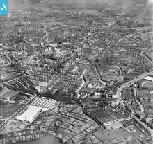
View from north-west. 18 May 1937 series. EPW053106 |
Nat |
Friday 27th of September 2013 05:45:12 PM |