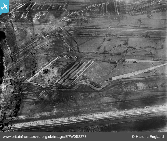
EPW052278 ENGLAND (1936). The site of the northern end of the William Girling Reservoir showing preliminary construction works, Ponders End, 1936. This image has been produced from a damaged negative.
© Hawlfraint cyfranwyr OpenStreetMap a thrwyddedwyd gan yr OpenStreetMap Foundation. 2026. Trwyddedir y gartograffeg fel CC BY-SA.
Delweddau cyfagos (29)
Manylion
| Pennawd | [EPW052278] The site of the northern end of the William Girling Reservoir showing preliminary construction works, Ponders End, 1936. This image has been produced from a damaged negative. |
| Cyfeirnod | EPW052278 |
| Dyddiad | November-1936 |
| Dolen | |
| Enw lle | PONDERS END |
| Plwyf | |
| Ardal | |
| Gwlad | ENGLAND |
| Dwyreiniad / Gogleddiad | 536760, 194809 |
| Hydred / Lledred | -0.0236345032971, 51.634973864215 |
| Cyfeirnod Grid Cenedlaethol | TQ368948 |
Pinnau
Byddwch y cyntaf i ychwanegu sylw at y ddelwedd hon!


![[EPW052278] The site of the northern end of the William Girling Reservoir showing preliminary construction works, Ponders End, 1936. This image has been produced from a damaged negative.](http://britainfromabove.org.uk/sites/all/libraries/aerofilms-images/public/100x100/EPW/052/EPW052278.jpg)
![[EPW056811] The William Girling Reservoir under construction, Edmonton, 1938](http://britainfromabove.org.uk/sites/all/libraries/aerofilms-images/public/100x100/EPW/056/EPW056811.jpg)
![[EPW052266] The site of the northern end of the William Girling Reservoir showing preliminary construction works, Ponders End, 1936](http://britainfromabove.org.uk/sites/all/libraries/aerofilms-images/public/100x100/EPW/052/EPW052266.jpg)
![[EPW060220] The northern part of the Chingford (William Girling) Reservoir under construction, Edmonton, 1938](http://britainfromabove.org.uk/sites/all/libraries/aerofilms-images/public/100x100/EPW/060/EPW060220.jpg)
![[EAW040926] The recently completed William Girling Reservoir beginning to fill up with water, Edmonton, 1951](http://britainfromabove.org.uk/sites/all/libraries/aerofilms-images/public/100x100/EAW/040/EAW040926.jpg)
![[EPW050861] The site of the northern end of the William Girling Reservoir showing preliminary construction works, Ponders End, 1936](http://britainfromabove.org.uk/sites/all/libraries/aerofilms-images/public/100x100/EPW/050/EPW050861.jpg)
![[EPW060630] Lea Valley Road and the William Girling Reservoir under construction, Enfield, 1939](http://britainfromabove.org.uk/sites/all/libraries/aerofilms-images/public/100x100/EPW/060/EPW060630.jpg)
![[EPW053845] The northern part of the Chingford (William Girling) Reservoir under construction, Edmonton, 1937](http://britainfromabove.org.uk/sites/all/libraries/aerofilms-images/public/100x100/EPW/053/EPW053845.jpg)
![[EPW058456] The northern part of the Chingford (William Girling) Reservoir under construction, Edmonton, 1938](http://britainfromabove.org.uk/sites/all/libraries/aerofilms-images/public/100x100/EPW/058/EPW058456.jpg)
![[EPW053846] The northern part of the Chingford (William Girling) Reservoir under construction, Edmonton, 1937](http://britainfromabove.org.uk/sites/all/libraries/aerofilms-images/public/100x100/EPW/053/EPW053846.jpg)
![[EPW049694] The site of the northern end of the William Girling Reservoir showing preliminary construction works, Ponders End, 1936](http://britainfromabove.org.uk/sites/all/libraries/aerofilms-images/public/100x100/EPW/049/EPW049694.jpg)
![[EPW053849] The northern part of the Chingford (William Girling) Reservoir under construction, Edmonton, 1937](http://britainfromabove.org.uk/sites/all/libraries/aerofilms-images/public/100x100/EPW/053/EPW053849.jpg)
![[EPW049524] Site of the William Girling Reservoir, Enfield, 1935](http://britainfromabove.org.uk/sites/all/libraries/aerofilms-images/public/100x100/EPW/049/EPW049524.jpg)
![[EPW049695] The site of the northern end of the William Girling Reservoir showing preliminary construction works, Ponders End, 1936](http://britainfromabove.org.uk/sites/all/libraries/aerofilms-images/public/100x100/EPW/049/EPW049695.jpg)
![[EPW053842] The northern part of the Chingford (William Girling) Reservoir under construction, Edmonton, 1937. This image has been affected by flare.](http://britainfromabove.org.uk/sites/all/libraries/aerofilms-images/public/100x100/EPW/053/EPW053842.jpg)
![[EPW048905] The Enfield Council Sewage Farm alongside the site of the William Girling Reservoir, Ponders End, 1935](http://britainfromabove.org.uk/sites/all/libraries/aerofilms-images/public/100x100/EPW/048/EPW048905.jpg)
![[EPW052277] The site of William Girling Reservoir showing preliminary construction works, Edmonton, 1936](http://britainfromabove.org.uk/sites/all/libraries/aerofilms-images/public/100x100/EPW/052/EPW052277.jpg)
![[EPW049705] The site of the northern end of the William Girling Reservoir showing preliminary construction works, Ponders End, 1936](http://britainfromabove.org.uk/sites/all/libraries/aerofilms-images/public/100x100/EPW/049/EPW049705.jpg)
![[EPW050866] The site of the William Girling Reservoir showing preliminary construction works, Edmonton, 1936](http://britainfromabove.org.uk/sites/all/libraries/aerofilms-images/public/100x100/EPW/050/EPW050866.jpg)
![[EPW050867] The site of the northern end of the William Girling Reservoir showing preliminary construction works, Ponders End, 1936](http://britainfromabove.org.uk/sites/all/libraries/aerofilms-images/public/100x100/EPW/050/EPW050867.jpg)
![[EPW056330] The northern end of the William Girling Reservoir under construction, Ponders End, 1938](http://britainfromabove.org.uk/sites/all/libraries/aerofilms-images/public/100x100/EPW/056/EPW056330.jpg)
![[EPW052689] Construction of the William Girling Reservoir and environs, Enfield, 1937](http://britainfromabove.org.uk/sites/all/libraries/aerofilms-images/public/100x100/EPW/052/EPW052689.jpg)
![[EPW056331] The William Girling Reservoir under construction, Edmonton, 1938](http://britainfromabove.org.uk/sites/all/libraries/aerofilms-images/public/100x100/EPW/056/EPW056331.jpg)
![[EPW060224] The Chingford (William Girling) Reservoir under construction, Edmonton, from the north, 1938](http://britainfromabove.org.uk/sites/all/libraries/aerofilms-images/public/100x100/EPW/060/EPW060224.jpg)
![[EPW060638] Lea Valley Road, King George's Reservoir and the William Girling Reservoir under construction, Enfield, 1939](http://britainfromabove.org.uk/sites/all/libraries/aerofilms-images/public/100x100/EPW/060/EPW060638.jpg)
![[EPW056826] The northern end of the William Girling Reservoir under construction, Ponders End, 1938](http://britainfromabove.org.uk/sites/all/libraries/aerofilms-images/public/100x100/EPW/056/EPW056826.jpg)
![[EPW060626] Lea Valley Road and the William Girling Reservoir under construction, Enfield, 1939](http://britainfromabove.org.uk/sites/all/libraries/aerofilms-images/public/100x100/EPW/060/EPW060626.jpg)
![[EPW058469] The northern part of the Chingford (William Girling) Reservoir under construction, Edmonton, 1938](http://britainfromabove.org.uk/sites/all/libraries/aerofilms-images/public/100x100/EPW/058/EPW058469.jpg)
![[EPW049718] The site of the William Girling Reservoir showing preliminary construction works, Edmonton, from the north, 1936](http://britainfromabove.org.uk/sites/all/libraries/aerofilms-images/public/100x100/EPW/049/EPW049718.jpg)