
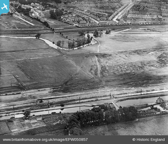
EPW050857 ENGLAND (1936). The site of the southern end of the William Girling Reservoir showing preliminary construction works, Edmonton, 1936
© Hawlfraint cyfranwyr OpenStreetMap a thrwyddedwyd gan yr OpenStreetMap Foundation. 2026. Trwyddedir y gartograffeg fel CC BY-SA.
Delweddau cyfagos (38)
EPW050857

EPW058472
 Reservoir under construction, Edmonton, 1938")
EPW055969

EAW040924

EPW056322

EPW056318

EAW044486

EPW055974

EPW060628

EPW060636

EAW044489

EPW053844
 Reservoir under construction, Edmonton, 1937")
EPW052286

EPW048912

EPW052279

EPW056812

EPW050865

EAW040927

EPW060643

EPW053847
 Reservoir under construction, Edmonton, 1937")
EPW056824

EPW060642

EPW060641

EPW058458
 Reservoir under construction, Edmonton, 1938")
EPW060633

EPW055973

EPW056323

EPW060640

EPW055972

EPW056324

EPW056828

EPW055970

EPW058463
 Reservoir under construction, Edmonton, from the south, 1938")
EPW055984

EPW055977

EPW053848
 Reservoir under construction, Edmonton, 1937")
EPW055985

EPW058459
 Reservoir under construction, Edmonton, 1938")
Manylion
| Pennawd | [EPW050857] The site of the southern end of the William Girling Reservoir showing preliminary construction works, Edmonton, 1936 |
| Cyfeirnod | EPW050857 |
| Dyddiad | July-1936 |
| Dolen | |
| Enw lle | EDMONTON |
| Plwyf | |
| Ardal | |
| Gwlad | ENGLAND |
| Dwyreiniad / Gogleddiad | 536493, 193663 |
| Hydred / Lledred | -0.027937345073119, 51.624739650153 |
| Cyfeirnod Grid Cenedlaethol | TQ365937 |
Pinnau

Neil H |
Tuesday 7th of May 2013 01:43:24 PM |
Cyfraniadau Grŵp
This photo is taken from the west side of the William Girling Reservoir looking east. Priory Avenue and Cherrydown Avenue are noticeable. Waltham Way runs right to left going north but its progress at the time is halted only 6 to 8 houses north of Priory Avenue. |
Neil H |
Tuesday 7th of May 2013 01:59:14 PM |