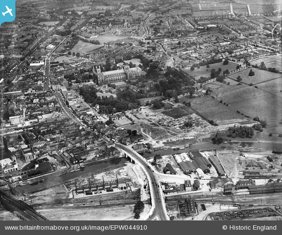
EPW044910 ENGLAND (1934). The Cathedral Church of St Peter, St Paul and St Andrew, the London Road Bridge and environs, Peterborough, 1934
© Hawlfraint cyfranwyr OpenStreetMap a thrwyddedwyd gan yr OpenStreetMap Foundation. 2026. Trwyddedir y gartograffeg fel CC BY-SA.
Delweddau cyfagos (22)
Manylion
| Pennawd | [EPW044910] The Cathedral Church of St Peter, St Paul and St Andrew, the London Road Bridge and environs, Peterborough, 1934 |
| Cyfeirnod | EPW044910 |
| Dyddiad | June-1934 |
| Dolen | |
| Enw lle | PETERBOROUGH |
| Plwyf | |
| Ardal | |
| Gwlad | ENGLAND |
| Dwyreiniad / Gogleddiad | 519376, 298394 |
| Hydred / Lledred | -0.23841038783151, 52.569894031855 |
| Cyfeirnod Grid Cenedlaethol | TL194984 |
Pinnau
Cyfraniadau Grŵp
Peterborough Cathedral, properly the Cathedral Church of St Peter, St Paul and St Andrew – also known as Saint Peter's Cathedral, Peterborough , 10/06/2014 |

Class31 |
Wednesday 11th of June 2014 08:30:44 AM |


![[EPW044910] The Cathedral Church of St Peter, St Paul and St Andrew, the London Road Bridge and environs, Peterborough, 1934](http://britainfromabove.org.uk/sites/all/libraries/aerofilms-images/public/100x100/EPW/044/EPW044910.jpg)
![[EAW005690] The Peterborough Lido, Peterborough, 1947](http://britainfromabove.org.uk/sites/all/libraries/aerofilms-images/public/100x100/EAW/005/EAW005690.jpg)
![[EAW009524] The city, Peterborough, from the south-east, 1947](http://britainfromabove.org.uk/sites/all/libraries/aerofilms-images/public/100x100/EAW/009/EAW009524.jpg)
![[EPW039168] The Cathedral Church of St Peter, St Paul and St Andrew and the city centre, Peterborough, from the south, 1932. This image has been produced from a copy-negative.](http://britainfromabove.org.uk/sites/all/libraries/aerofilms-images/public/100x100/EPW/039/EPW039168.jpg)
![[EPW050306] Narrow Bridge Street and the city centre, Peterborough, 1936](http://britainfromabove.org.uk/sites/all/libraries/aerofilms-images/public/100x100/EPW/050/EPW050306.jpg)
![[EPW044922] London Road Bridge, Broad Bridge Street and environs, Peterborough, 1934](http://britainfromabove.org.uk/sites/all/libraries/aerofilms-images/public/100x100/EPW/044/EPW044922.jpg)
![[EPW044920] London Road Bridge, the River Nene and environs, Peterborough, 1934](http://britainfromabove.org.uk/sites/all/libraries/aerofilms-images/public/100x100/EPW/044/EPW044920.jpg)
![[EPW044918] London Road Bridge, the River Nene and environs, Peterborough, 1934](http://britainfromabove.org.uk/sites/all/libraries/aerofilms-images/public/100x100/EPW/044/EPW044918.jpg)
![[EPW044919] London Road Bridge, Broad Bridge Street and environs, Peterborough, 1934](http://britainfromabove.org.uk/sites/all/libraries/aerofilms-images/public/100x100/EPW/044/EPW044919.jpg)
![[EPW044921] London Road Bridge, Broad Bridge Street and environs, Peterborough, 1934](http://britainfromabove.org.uk/sites/all/libraries/aerofilms-images/public/100x100/EPW/044/EPW044921.jpg)
![[EPW009852] The Cathedral Church of St Peter, St Paul and St Andrew, Peterborough, 1924. This image has been produced from a copy-negative.](http://britainfromabove.org.uk/sites/all/libraries/aerofilms-images/public/100x100/EPW/009/EPW009852.jpg)
![[EPW044907] The Cathedral Church of St Peter, St Paul and St Andrew and the city centre, Peterborough, 1934. This image has been affected by flare.](http://britainfromabove.org.uk/sites/all/libraries/aerofilms-images/public/100x100/EPW/044/EPW044907.jpg)
![[EPW039170] The Cathedral Church of St Peter, St Paul and St Andrew, Peterborough, 1932. This image has been produced from a copy-negative.](http://britainfromabove.org.uk/sites/all/libraries/aerofilms-images/public/100x100/EPW/039/EPW039170.jpg)
![[EPW044909] The Cathedral Church of St Peter, St Paul and St Andrew and environs, Peterborough, 1934](http://britainfromabove.org.uk/sites/all/libraries/aerofilms-images/public/100x100/EPW/044/EPW044909.jpg)
![[EPW044905] Broad Bridge Street, the cathedral and environs, Peterborough, 1934](http://britainfromabove.org.uk/sites/all/libraries/aerofilms-images/public/100x100/EPW/044/EPW044905.jpg)
![[EPW009853] The Cathedral Church of St Peter, St Paul and St Andrew, Peterborough, 1924. This image has been produced from a copy-negative.](http://britainfromabove.org.uk/sites/all/libraries/aerofilms-images/public/100x100/EPW/009/EPW009853.jpg)
![[EAW005687] Peterborough Cathedral and the city centre, Peterborough, 1947](http://britainfromabove.org.uk/sites/all/libraries/aerofilms-images/public/100x100/EAW/005/EAW005687.jpg)
![[EPW050307] St Peter's Cathedral and the city centre, Peterborough, 1936](http://britainfromabove.org.uk/sites/all/libraries/aerofilms-images/public/100x100/EPW/050/EPW050307.jpg)
![[EPW044906] London Road Bridge and environs, Peterborough, 1934](http://britainfromabove.org.uk/sites/all/libraries/aerofilms-images/public/100x100/EPW/044/EPW044906.jpg)
![[EPW036807] The Old Customs House and a bridge over the River Nene joining Bridge Street and London Street, Peterborough, 1931](http://britainfromabove.org.uk/sites/all/libraries/aerofilms-images/public/100x100/EPW/036/EPW036807.jpg)
![[EPW036803] The Old Customs House and a bridge over the River Nene joining Bridge Street and London Street, Peterborough, 1931](http://britainfromabove.org.uk/sites/all/libraries/aerofilms-images/public/100x100/EPW/036/EPW036803.jpg)
![[EPW036795] A bridge over the River Nene joining Bridge Street and London Street, Peterborough, 1931](http://britainfromabove.org.uk/sites/all/libraries/aerofilms-images/public/100x100/EPW/036/EPW036795.jpg)