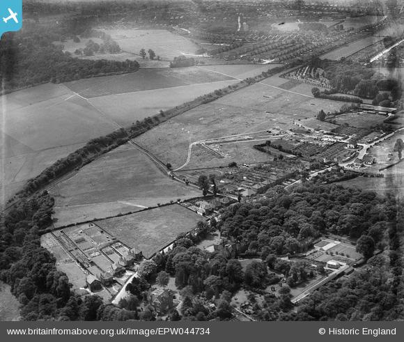
EPW044734 ENGLAND (1934). Hurst Road, the SR Dartford Loop and environs, Bexley Woods, 1934
    © Hawlfraint cyfranwyr OpenStreetMap a thrwyddedwyd gan yr OpenStreetMap Foundation. 2025. Trwyddedir y gartograffeg fel CC BY-SA.
  
Delweddau cyfagos (9)
Manylion
| Pennawd | [EPW044734] Hurst Road, the SR Dartford Loop and environs, Bexley Woods, 1934 | 
| Cyfeirnod | EPW044734 | 
| Dyddiad | July-1934 | 
| Dolen | |
| Enw lle | BEXLEY WOODS | 
| Plwyf | |
| Ardal | |
| Gwlad | ENGLAND | 
| Dwyreiniad / Gogleddiad | 548146, 173115 | 
| Hydred / Lledred | 0.13165998003249, 51.437143639397 | 
| Cyfeirnod Grid Cenedlaethol | TQ481731 | 
Pinnau
|  Faraday Avenue |   Barney | Sunday 20th of August 2017 08:25:10 AM | 
|  Lewis road shops |   Barney | Sunday 20th of August 2017 08:23:58 AM | 
|  Lodge to Foots Cray Place, location now number 2a Harefield road. |   Barney | Sunday 20th of August 2017 08:22:47 AM | 
|  Bexley Lane. |   Barney | Sunday 20th of August 2017 08:16:43 AM | 
|  Bexley Park Wood. |   Barney | Saturday 18th of March 2017 12:42:02 PM | 
|  Hurst Springs. |   Barney | Saturday 18th of March 2017 12:41:24 PM | 
|  Site of future Albany Park railway station, opened 7th July 1935. |   Barney | Saturday 18th of March 2017 12:39:44 PM | 
|  Valentine Avenue. |   Barney | Saturday 18th of March 2017 12:37:45 PM | 
|  Sidcup hill. |   Barney | Saturday 18th of March 2017 12:36:49 PM | 
|  Footscray Place house. |   Barney | Saturday 18th of March 2017 12:36:02 PM | 
|  North Cray Wood. |   Barney | Saturday 18th of March 2017 12:35:01 PM | 
|  Birchwood Avenue. |   Barney | Saturday 18th of March 2017 12:32:58 PM | 
|  Waring Park. |   Barney | Saturday 18th of March 2017 12:32:20 PM | 
|  Penfolds lane. |   Barney | Saturday 18th of March 2017 12:30:46 PM | 
|  Hurst farm, you can just see a Oast house. |   Barney | Saturday 18th of March 2017 12:29:56 PM | 
|  Rutland Shaw. |   Barney | Saturday 18th of March 2017 12:28:36 PM | 
|  Sidcup Cemetery, Footscray lane. |   Barney | Saturday 18th of March 2017 12:27:57 PM | 
 
             
  ![[EPW044734] Hurst Road, the SR Dartford Loop and environs, Bexley Woods, 1934](http://britainfromabove.org.uk/sites/all/libraries/aerofilms-images/public/100x100/EPW/044/EPW044734.jpg) 
  
                                          ![[EPW044377] Hurst Road and environs, Bexley Woods, 1934](http://britainfromabove.org.uk/sites/all/libraries/aerofilms-images/public/100x100/EPW/044/EPW044377.jpg) 
 ![[EPW044379] Hurst Road and environs, Bexley Woods, 1934](http://britainfromabove.org.uk/sites/all/libraries/aerofilms-images/public/100x100/EPW/044/EPW044379.jpg) 
 ![[EPW044736] Hurst Road, Valentine Avenue, the SR Dartford Loop and environs, Bexley Woods, 1934](http://britainfromabove.org.uk/sites/all/libraries/aerofilms-images/public/100x100/EPW/044/EPW044736.jpg) 
 ![[EPW044378] Hurst Road and environs, Bexley Woods, 1934](http://britainfromabove.org.uk/sites/all/libraries/aerofilms-images/public/100x100/EPW/044/EPW044378.jpg) 
 ![[EPW044735] Hurst Road, the SR Dartford Loop and environs, Bexley Woods, 1934](http://britainfromabove.org.uk/sites/all/libraries/aerofilms-images/public/100x100/EPW/044/EPW044735.jpg) 
 ![[EPW044732] Hurst Road, the SR Dartford Loop and environs, Bexley Woods, 1934](http://britainfromabove.org.uk/sites/all/libraries/aerofilms-images/public/100x100/EPW/044/EPW044732.jpg) 
 ![[EPW044718] The Albany Park Estate under construction centred upon Murchison, Dorchester and Crofton Avenues, Bexley Woods, from the south-east, 1934](http://britainfromabove.org.uk/sites/all/libraries/aerofilms-images/public/100x100/EPW/044/EPW044718.jpg) 
 ![[EPW044376] The SR Dartford Loop Line and housing under construction to the north of Hurst Road along Dorchester Avenue and Murchison Avenue, Bexley Woods, 1934](http://britainfromabove.org.uk/sites/all/libraries/aerofilms-images/public/100x100/EPW/044/EPW044376.jpg)