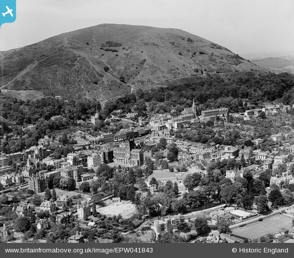
EPW041843 ENGLAND (1933). The town centre, Great Malvern, 1933
    © Hawlfraint cyfranwyr OpenStreetMap a thrwyddedwyd gan yr OpenStreetMap Foundation. 2025. Trwyddedir y gartograffeg fel CC BY-SA.
  
Delweddau cyfagos (7)
Manylion
| Pennawd | [EPW041843] The town centre, Great Malvern, 1933 | 
| Cyfeirnod | EPW041843 | 
| Dyddiad | July-1933 | 
| Dolen | |
| Enw lle | GREAT MALVERN | 
| Plwyf | MALVERN | 
| Ardal | |
| Gwlad | ENGLAND | 
| Dwyreiniad / Gogleddiad | 377440, 246032 | 
| Hydred / Lledred | -2.3294738391273, 52.111739986065 | 
| Cyfeirnod Grid Cenedlaethol | SO774460 | 
Pinnau
Byddwch y cyntaf i ychwanegu sylw at y ddelwedd hon!
 
             
  ![[EPW041843] The town centre, Great Malvern, 1933](http://britainfromabove.org.uk/sites/all/libraries/aerofilms-images/public/100x100/EPW/041/EPW041843.jpg) 
  
                                          ![[EAW006884] The northern end of the Malvern Hills and the town, Great Malvern, 1947](http://britainfromabove.org.uk/sites/all/libraries/aerofilms-images/public/100x100/EAW/006/EAW006884.jpg) 
 ![[EPW041840] The Priory Church of St Mary and environs, Great Malvern, 1933](http://britainfromabove.org.uk/sites/all/libraries/aerofilms-images/public/100x100/EPW/041/EPW041840.jpg) 
 ![[EPW061946] The Malvern Hills, Great Malvern, 1939](http://britainfromabove.org.uk/sites/all/libraries/aerofilms-images/public/100x100/EPW/061/EPW061946.jpg) 
 ![[EPW005393] The Priory Church of St Mary and St Michael, Great Malvern, 1921](http://britainfromabove.org.uk/sites/all/libraries/aerofilms-images/public/100x100/EPW/005/EPW005393.jpg) 
 ![[EPW006028] The Priory Church of St Mary and St Michael, Great Malvern, 1921. This image has been produced from a copy-negative.](http://britainfromabove.org.uk/sites/all/libraries/aerofilms-images/public/100x100/EPW/006/EPW006028.jpg) 
 ![[EAW006883] North Hill and the town, Great Malvern, 1947](http://britainfromabove.org.uk/sites/all/libraries/aerofilms-images/public/100x100/EAW/006/EAW006883.jpg)