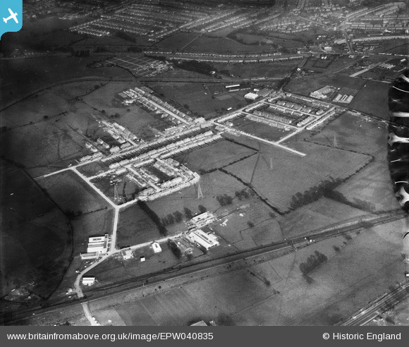
EPW040835 ENGLAND (1933). Factories under construction at Wadsworth Road, and housing under construction around Sarsfield Road and Bilton Road, Perivale, 1933
    © Hawlfraint cyfranwyr OpenStreetMap a thrwyddedwyd gan yr OpenStreetMap Foundation. 2025. Trwyddedir y gartograffeg fel CC BY-SA.
  
Delweddau cyfagos (15)
Manylion
| Pennawd | [EPW040835] Factories under construction at Wadsworth Road, and housing under construction around Sarsfield Road and Bilton Road, Perivale, 1933 | 
| Cyfeirnod | EPW040835 | 
| Dyddiad | March-1933 | 
| Dolen | |
| Enw lle | PERIVALE | 
| Plwyf | |
| Ardal | |
| Gwlad | ENGLAND | 
| Dwyreiniad / Gogleddiad | 517128, 183461 | 
| Hydred / Lledred | -0.31098638664676, 51.537404370746 | 
| Cyfeirnod Grid Cenedlaethol | TQ171835 | 
 
             
  ![[EPW040835] Factories under construction at Wadsworth Road, and housing under construction around Sarsfield Road and Bilton Road, Perivale, 1933](http://britainfromabove.org.uk/sites/all/libraries/aerofilms-images/public/100x100/EPW/040/EPW040835.jpg) 
  
                                          ![[EPW040871] Housing development at Bilton Road and environs, Perivale,  1933](http://britainfromabove.org.uk/sites/all/libraries/aerofilms-images/public/100x100/EPW/040/EPW040871.jpg) 
 ![[EPW042711] A new housing estate, Perivale, 1933](http://britainfromabove.org.uk/sites/all/libraries/aerofilms-images/public/100x100/EPW/042/EPW042711.jpg) 
 ![[EAW007191] The Perivale Industrial Park, Perivale, 1947](http://britainfromabove.org.uk/sites/all/libraries/aerofilms-images/public/100x100/EAW/007/EAW007191.jpg) 
 ![[EAW007189] The Perivale Industrial Park, Perivale, 1947](http://britainfromabove.org.uk/sites/all/libraries/aerofilms-images/public/100x100/EAW/007/EAW007189.jpg) 
 ![[EPR000614] The Central Joinery Co Ltd Works, Perivale, 1935. This image was marked by Aero Pictorial Ltd for photo editing.](http://britainfromabove.org.uk/sites/all/libraries/aerofilms-images/public/100x100/EPR/000/EPR000614.jpg) 
 ![[EPW060622] International Tin Research and Development Council Office and Laboratory on Fraser Road, Perivale, 1939](http://britainfromabove.org.uk/sites/all/libraries/aerofilms-images/public/100x100/EPW/060/EPW060622.jpg) 
 ![[EPW060625] International Tin Research and Development Council Office and Laboratory on Fraser Road, Perivale, 1939](http://britainfromabove.org.uk/sites/all/libraries/aerofilms-images/public/100x100/EPW/060/EPW060625.jpg) 
 ![[EPW060624] International Tin Research and Development Council Office and Laboratory on Fraser Road, Perivale, 1939](http://britainfromabove.org.uk/sites/all/libraries/aerofilms-images/public/100x100/EPW/060/EPW060624.jpg) 
 ![[EPW060620] International Tin Research and Development Council Office and Laboratory on Fraser Road, Perivale, 1939](http://britainfromabove.org.uk/sites/all/libraries/aerofilms-images/public/100x100/EPW/060/EPW060620.jpg) 
 ![[EPW060623] International Tin Research and Development Council Office and Laboratory on Fraser Road, Perivale, 1939](http://britainfromabove.org.uk/sites/all/libraries/aerofilms-images/public/100x100/EPW/060/EPW060623.jpg) 
 ![[EPW060621] International Tin Research and Development Council Office and Laboratory on Fraser Road, Perivale, 1939](http://britainfromabove.org.uk/sites/all/libraries/aerofilms-images/public/100x100/EPW/060/EPW060621.jpg) 
 ![[EPW060619] International Tin Research and Development Council Office and Laboratory on Fraser Road, Perivale, 1939](http://britainfromabove.org.uk/sites/all/libraries/aerofilms-images/public/100x100/EPW/060/EPW060619.jpg) 
 ![[EPW043716] A new housing estate off Bilton Road, Perivale, from the south, 1934](http://britainfromabove.org.uk/sites/all/libraries/aerofilms-images/public/100x100/EPW/043/EPW043716.jpg) 
 ![[EAW004302] The Perivale Industrial Park and the surrounding residential area, Perivale, 1947](http://britainfromabove.org.uk/sites/all/libraries/aerofilms-images/public/100x100/EAW/004/EAW004302.jpg) 
  Bridgewater Road
 Bridgewater Road